Riksgränsen
| Riksgränsen | |
|---|---|
 Lift in Riksgränsen | |
| Coordinates | 68°25′40″N 18°07′20″E / 68.42778°N 18.12222°ECoordinates: 68°25′40″N 18°07′20″E / 68.42778°N 18.12222°E |
| Vertical | 410 m (1,350 ft) |
| Runs | 28 |
| Lift system | 6 |
| Lift capacity | 7400 passengers/hr |
| Night skiing | Selected days (under midnight sun) |

Riksgränsen, (Norwegian: Riksgrensen), The National Border in Swedish, is a ski-resort in Kiruna Municipality, Lappland, Sweden, 200 km north of the Arctic Circle. The skiing season is from February to June. From end of May the lifts operate under the midnight sun.
Riksgränsen is a popular location for the winter testing of pre-production cars by various European manufacturers. Photo-snipers are prevalent, attempting to get the first spy-shots of new models, though their activities are frowned upon by local hoteliers who value the custom of the manufacturers. The same manufacturers frequently use the location for winter launches, bringing journalists from across the world to drive the new cars on snow-covered roads and on courses specially prepared on frozen lakes.
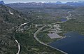
Riksgränsen, August 1994
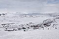
Riksgränsen, May 2020


| |||||||||||||||||||||||||||||||||||||||||||||||||||||||||||||||||||||||||||||||||||||||||||||||||||||||||||||||||||||||||||||||||||||||||||||||||||||||||||||||||||||||||||||||||||||||||||||||||||||||||||||||||||||||||||||||||||||||||||||||||||||||||||||||||||||||||||||||||||||||||||||||||||||||||||||||||||||||||||||||||||||||||||||||||||||||||||||||||||||||||||||||||||||||||
|
| |||||||||||||||||||||||||||||||||||||||||||||||||||||||||||||||||||||||||||||||||||||||||||||||||||||||||||||||||||||||||||||||||||||||||||||||||||||||||||||||||||||||||||||||||||||||||||||||||||||||||||||||||||||||||||||||||||||||||||||||||||||||||||||||||||||||||||||||||||||||||||||||||||||||||||||||||||||||||||||||||||||||||||||||||||||||||||||||||||||||||||||||||||||||||
Climate[]
Although the subarctic climate (Koppen: Dfc) of the region is very cold, it has considerably milder winters than normally expected for an inland northerly area, due to its proximity to the warm North Atlantic Current. Summers do remain cool in spite of the midnight sun due to similar maritime effects. With prevailing low-pressure systems taking precedence, the climate is snowy and cloudy. The deep snow cover and the time it takes for thawing prolongs the skiing season to the midnight sun window. The snow depth can be above 200 centimetres (6.6 ft) in unshovelled areas during spring. The snow depth charts have sometimes ended during late May when the pack has been shrinking, which skews the June readings that likely are a bit higher. In 2020 145 centimetres (4.76 ft) snow cover was measured in that month.[1]
| Climate data for Katterjåkk, 2002–2020 (extremes since 1901) | |||||||||||||
|---|---|---|---|---|---|---|---|---|---|---|---|---|---|
| Month | Jan | Feb | Mar | Apr | May | Jun | Jul | Aug | Sep | Oct | Nov | Dec | Year |
| Record high °C (°F) | 7.1 (44.8) |
6.4 (43.5) |
7.0 (44.6) |
12.6 (54.7) |
23.5 (74.3) |
27.8 (82.0) |
30.0 (86.0) |
28.2 (82.8) |
21.8 (71.2) |
14.7 (58.5) |
10.4 (50.7) |
8.5 (47.3) |
30.0 (86.0) |
| Mean maximum °C (°F) | 2.8 (37.0) |
2.6 (36.7) |
3.3 (37.9) |
7.4 (45.3) |
14.2 (57.6) |
20.3 (68.5) |
23.6 (74.5) |
22.1 (71.8) |
16.3 (61.3) |
8.9 (48.0) |
5.2 (41.4) |
3.7 (38.7) |
24.5 (76.1) |
| Average high °C (°F) | −7.0 (19.4) |
−6.7 (19.9) |
−3.9 (25.0) |
1.2 (34.2) |
6.1 (43.0) |
11.8 (53.2) |
16.4 (61.5) |
14.3 (57.7) |
8.9 (48.0) |
2.0 (35.6) |
−1.8 (28.8) |
−4.1 (24.6) |
3.1 (37.6) |
| Daily mean °C (°F) | −10.5 (13.1) |
−10.2 (13.6) |
−7.3 (18.9) |
−2.2 (28.0) |
2.9 (37.2) |
8.1 (46.6) |
12.4 (54.3) |
10.7 (51.3) |
6.0 (42.8) |
−0.5 (31.1) |
−4.7 (23.5) |
−7.4 (18.7) |
−0.2 (31.6) |
| Average low °C (°F) | −14.0 (6.8) |
−13.6 (7.5) |
−10.7 (12.7) |
−5.6 (21.9) |
−0.4 (31.3) |
4.4 (39.9) |
8.3 (46.9) |
7.1 (44.8) |
3.1 (37.6) |
−2.9 (26.8) |
−7.5 (18.5) |
−10.6 (12.9) |
−3.5 (25.6) |
| Mean minimum °C (°F) | −24.8 (−12.6) |
−25.4 (−13.7) |
−21.0 (−5.8) |
−15.0 (5.0) |
−7.5 (18.5) |
−0.4 (31.3) |
3.6 (38.5) |
1.6 (34.9) |
−2.8 (27.0) |
−11.0 (12.2) |
−16.2 (2.8) |
−20.9 (−5.6) |
−28.0 (−18.4) |
| Record low °C (°F) | −34.5 (−30.1) |
−35.2 (−31.4) |
−30.9 (−23.6) |
−24.0 (−11.2) |
−15.1 (4.8) |
−9.0 (15.8) |
−0.5 (31.1) |
−3.0 (26.6) |
−8.8 (16.2) |
−20.0 (−4.0) |
−25.0 (−13.0) |
−33.0 (−27.4) |
−35.2 (−31.4) |
| Average precipitation mm (inches) | 79.5 (3.13) |
68.0 (2.68) |
73.3 (2.89) |
45.1 (1.78) |
47.4 (1.87) |
71.7 (2.82) |
82.2 (3.24) |
73.6 (2.90) |
105.6 (4.16) |
80.8 (3.18) |
65.4 (2.57) |
83.1 (3.27) |
875.7 (34.49) |
| Average extreme snow depth cm (inches) | 104 (41) |
131 (52) |
155 (61) |
157 (62) |
130 (51) |
36 (14) |
0 (0) |
0 (0) |
5 (2.0) |
24 (9.4) |
43 (17) |
78 (31) |
163 (64) |
| Mean monthly sunshine hours | 0 | 22 | 88 | 153 | 201 | 201 | 217 | 153 | 80 | 42 | 1 | 0 | 1,158 |
| Source: [2] | |||||||||||||
References[]
- ^ "Ladda ner meteorologiska observationer för Katterjåkk" (in Swedish). SMHI. Retrieved 27 May 2021.
- ^ "SMHI". Archived from the original on 2013-02-13.
External links[]
- Lapland (Sweden)
- Ski areas and resorts in Sweden
- Buildings and structures in Norrbotten County
- Tourist attractions in Norrbotten County