Rio, Greece
Rio
Ρίο | |
|---|---|
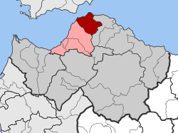
 Rio show Location within the regional unit | |
| Coordinates: 38°18′N 21°47′E / 38.300°N 21.783°ECoordinates: 38°18′N 21°47′E / 38.300°N 21.783°E | |
| Country | Greece |
| Administrative region | West Greece |
| Regional unit | Achaea |
| Municipality | Patras |
| • Municipal unit | 98.983 km2 (38.218 sq mi) |
| Elevation | 40 m (130 ft) |
| Population (2011)[1] | |
| • Municipal unit | 14,622 |
| • Municipal unit density | 150/km2 (380/sq mi) |
| Community | |
| • Population | 5,252 (2011) |
| Time zone | UTC+2 (EET) |
| • Summer (DST) | UTC+3 (EEST) |
| Postal code | 265 xx |
| Area code(s) | 2610 |
| Vehicle registration | ΑΧ |
Rio (Greek: Ρίο, Río, formerly Ῥίον, Rhíon; Latin: Rhium) is a town in the suburbs of Patras and a former municipality in Achaea, West Greece, Greece. Since the 2011 local government reform it is part of the municipality Patras, of which it is a municipal unit.[2] The municipal unit has an area of 98.983 km2.[3] The municipal unit had a population of 14,622 in 2011. The campus of the University of Patras and the Casino Rio is located in Rio.
Geography[]
Rion is the northernmost municipal unit of the Peloponnese peninsula. It stretches along the southeastern coast of the Gulf of Patras, about 7 km northeast of Patras city centre. The nearby Strait of Rio, crossed by the Rio–Antirrio bridge, separates the Gulf of Patras from the Gulf of Corinth to the east. The town is dominated by the Panachaiko mountain to the southeast.
Town layout[]
The town centre is also known as Agios Georgios Riou. This is where the Rio railway station, on the line from Patras to Corinth, is located. The quarter Kastellokampos lies to the southwest of the centre. The ferry terminals, with services to Antirrio, are in the north, on both sides of the Rio–Antirrio bridge. There is a large fortress with bastions next to the bridge. The campus of the University of Patras and the hospital lie in the southeast, across the Greek National Road 8A. There are sandy beaches along the coast, and a port north of town centre.
Subdivisions[]
The municipal unit Rio is subdivided into the following communities (constituent villages in brackets):
- Agios Vasileios
- Ano Kastritsi
- Arachovitika (Arachovitika, Kato Arachovitika)
- Argyra
- Drepano
- Kato Kastritsi (Kato Kastritsi, Magoula)
- Pititsa
- Platani
- Psathopyrgos (Psathopyrgos, Kato Rodini)
- Rio
- Sella
History[]
The name Rio (and its older form Rhion) derives from the Greek ῥίον (rhion), generally meaning "jutting part",[4] perhaps from ῥίς (rhis), meaning "nose", but also "spur of land".[5] The earliest attested form of the word is the Mycenaean Greek

