Rio Puerco Bridge
Rio Puerco Bridge | |
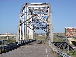 Photo in 2006 shows it is already out of service | |
 | |
| Nearest city | Albuquerque, New Mexico |
|---|---|
| Coordinates | 35°02′01″N 106°56′32″W / 35.0335°N 106.9421°WCoordinates: 35°02′01″N 106°56′32″W / 35.0335°N 106.9421°W |
| Area | less than one acre |
| Built | 1933 |
| Built by | ; F.D. Shufflebarger |
| Architectural style | Parker through truss bridge |
| MPS | Historic Highway Bridges of New Mexico MPS |
| NRHP reference No. | 97000735[1] |
| Added to NRHP | July 15, 1997 |


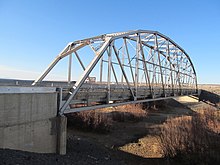
The Rio Puerco Bridge is a Parker through truss bridge located on historic U.S. Route 66 (US 66) in western Bernalillo County, New Mexico, United States, that is listed on the National Register of Historic Places (NRHP).[1]
Description[]
The bridge crosses the Rio Puerco and was built in 1933. It is located approximately 19 miles (31 km) west of Albuquerque.
It was built to carry a past alignment of US 66 over the Rio Puerco, and in 1997 carried a frontage road for Interstate 40 (I-40).[2] It no longer carries traffic, and has been bypassed by a different frontage road bridge.[3]
The single-span Parker through truss steel bridge was fabricated by the and built by F.D. Shufflebarger in 1933. Its substructure includes two concrete piers and massive concrete abutments set upon timber pilings. The total bridge length is 330 feet (100 m), including the 250 feet (76 m) span, which has ten 25 feet (7.6 m) panels, and two 40 feet (12 m) approaches.[2]
It is located 40 yards (37 m) north of the I-40, about 8.9 miles (14.3 km) west of I-40 westernmost exit at Albuquerque.[2]
The bridge was added to the NRHP July 15, 1997.[1]
See also[]
References[]
- ^ a b c "National Register Information System". National Register of Historic Places. National Park Service. July 9, 2010.
- ^ a b c Kammer, David (December 1996). "National Register of Historic Places Inventory/Nomination: Rio Puerco Bridge / NMSHTD #2530". National Park Service. Retrieved October 29, 2018. With accompanying three photos from 1984
- ^ Google (October 7, 2021). "Rio Puerco Bridge" (Map). Google Maps. Google. Retrieved October 7, 2021. (as well as by 2006 and 2012 photos)
External links[]
![]() Media related to Rio Puerco Bridge at Wikimedia Commons
Media related to Rio Puerco Bridge at Wikimedia Commons
| Topics | |
|---|---|
| Lists by state |
|
| Lists by insular areas | |
| Lists by associated state | |
| Other areas | |
| Related | |
| |
This article about a property in New Mexico on the National Register of Historic Places is a stub. You can help Wikipedia by . |
This article about a bridge in New Mexico is a stub. You can help Wikipedia by . |
- Road bridges on the National Register of Historic Places in New Mexico
- Bridges on U.S. Route 66
- Buildings and structures in Bernalillo County, New Mexico
- Transportation in Bernalillo County, New Mexico
- Road bridges in New Mexico
- U.S. Route 66 in New Mexico
- National Register of Historic Places in Bernalillo County, New Mexico
- Parker truss bridges in the United States
- New Mexico Registered Historic Place stubs
- Western United States bridge (structure) stubs
- New Mexico building and structure stubs