River Deben
This article needs additional citations for verification. (January 2017) |
| Deben | |
|---|---|
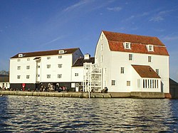 Woodbridge Tide Mill from the River Deben | |
 Location of the river mouth within Suffolk | |
| Location | |
| Country | England |
| Region | Suffolk |
| Physical characteristics | |
| Source | Bedingfield |
| • coordinates | 52°15′34″N 1°11′14″E / 52.2594°N 1.1873°E |
| • elevation | 60 m (200 ft) |
| 2nd source | Debenham |
| • coordinates | 52°13′35″N 1°08′01″E / 52.2263°N 1.1336°E |
| • elevation | 54 m (177 ft) |
| Mouth | North Sea near Felixstowe |
• coordinates | 51°58′51″N 1°23′34″E / 51.9808°N 1.3927°ECoordinates: 51°58′51″N 1°23′34″E / 51.9808°N 1.3927°E |
• elevation | 0 m (0 ft) |
| Length | 54 km (34 mi) |

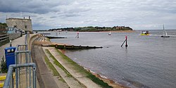
The River Deben is a river in Suffolk rising to the west of Debenham, though a second, higher source runs south from the parish of Bedingfield. The river passes through Woodbridge, turning into a tidal estuary before entering the North Sea at Felixstowe Ferry. The mouth of the estuary is crossed by a ferry connecting Felixstowe and Bawdsey.[1]
History[]
Both the river-name and the name of the village of Debenham are of uncertain origin and relationship,[2] but one theory (of several on offer) is that the river's name was originally Dēope meaning 'the deep one'.[3] The river-name, however, is not recorded in the form Deben before 1735, when it appears thus in Kirby's Suffolk Traveller. The river, though still little more than a stream, is forded twice in the village, with one ford claimed to be among the longest in England.[4]
Tide mills at Woodbridge have operated off the tide from the river Deben since at least 1170. The present mill, built in 1793, is producing stone ground wholemeal flour in the traditional way.[5]
Ecology[]
The Deben Estuary is a Special Protection Area and Ramsar Site and within the Suffolk Coast and Heaths Area of Outstanding Natural Beauty. Its significance arises from its over-wintering population of avocets (Recurvirostra avosetta). The estuary features shifting sandbanks. Plant life is dominated by the common reed (Phragmites australis). The salt marsh and intertidal mud-flats that occupy most of the area have the widest range of salt marsh flora in Suffolk.
Leisure[]
There are several yacht and dinghy clubs on the river Deben. These include the Deben Rowing Club, Deben Yacht Club, the , Felixstowe Ferry Sailing Club and the Woodbridge Cruising Club. There are two yacht harbours, the Tidemill Yacht Harbour, close to the Tide Mill; and the Granary Yacht Harbour, further upstream at Melton. The river Deben is a popular location for many other water sports including canoeing, wakeboarding, paddle boarding and windsurfing. The area where the river Deben enters the North Sea at Felixstowe Ferry is also a popular location for the sport of kitesurfing. Kitesurfers can usually be seen around low tide when the wind conditions are favourable, ranging from NE round to SW and depending on the direction of the tide.
See also[]
- Bawdsey Ferry
- River Alde
- Suffolk Coast and Heaths
References[]
- ^ Ordnance Survey of Great Britain
- ^ Keith Briggs and Kelly Kilpatrick. A dictionary of Suffolk place-names. English Place-Name Society.
- ^ A. D. Mills. A Dictionary of British Place-Names. Oxford University Press.
- ^ "Fords in Suffolk". Wet Roads. Retrieved 9 December 2013.
- ^ "History". Woodbridge Tide Mill.
External links[]
| Wikimedia Commons has media related to River Deben. |
- River Deben Navigation Information
- SPA designation
- Deben Yacht Club
- Map sources for River Deben
| show Authority control |
|---|
- Rivers of Suffolk
- Ramsar sites in England
- Special Protection Areas in England