River Quoile
Coordinates: 54°22′12″N 5°40′38″W / 54.37000°N 5.67722°W

| River Quoile | |
|---|---|
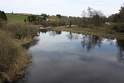 River Quoile, from Quoile Bridge, April 2010 | |
 Map of Strangford Lough; River Quoile is visible to its south | |
| Etymology | Irish caol, "narrow" |
| Native name | An Caol (Irish) |
| Location | |
| Country | United Kingdom |
| Constituent country | Northern Ireland |
| County | Down |
| Physical characteristics | |
| Source | |
| • location | Ballynahinch River |
| Mouth | Strangford Lough |
• location | North of Downpatrick |
| Length | 27.5 mi (44.3 km) |
The Quoile (/ˈkwɔɪl/; from Irish An Caol 'the narrow') is a river in County Down, Northern Ireland.
Course[]
The river begins its life as the Ballynahinch River which flows from west of the town of Ballynahinch to Annacloy where it is known as the Annacloy River. This then becomes the Quoile proper, which flows through Downpatrick and the Quoile Pondage before finally emptying into Strangford Lough.
History[]
The river was effectively created when Edward Southwell (1705–1755) landlord of Downpatrick built a tidal barrier at the Quoile and began draining the land, creating 500 acres of land from what was previously the western branch of Strangford Lough. The name comes from the narrowest point of the estuary at Finnebrogue, where a ford and ferry existed before the construction of the bridge. Harris, in 1744, mistakenly writes that the name of the bridge should be Coyne (after the branch of Loch Cuan up stream) not Coyle because he overlooked the origin.
Inch Abbey[]

On the north bank of the river, 0.75 miles (1.2 km) north-west of Downpatrick, the Inch Abbey site was originally on an island (Irish: Inis) in the Quoile Marshes. The pre-Norman Celtic monastic settlement here, known as Inis Cumhscraigh (or Inis Cuscraidh),[1] was in existence by the year 800. In 1002 it was plundered by the Vikings led by Sitric,[2] King of the Danes, who came up the Quoile with a fleet from the sea. The Vikings plundered the settlement again in 1149.[1]
Quoile Castle[]
Quoile Castle is situated 1.5 miles (2.4 km) from Downpatrick, just off the main road from Downpatrick to Strangford, on the east bank of the river. It is a 16th-century Tower house which was inhabited into the 18th century.[3]
Quoile Pondage National Nature Reserve[]
See also[]
- List of rivers of Northern Ireland
References[]
- ^ a b Donnelly, CJ (1997). Living Places. Belfast: Institute of Irish Studies, QUB. pp. 85–88. ISBN 9780853894759.
- ^ Government of Northern Ireland (1947). An Account of the Ancient Monuments in State Charge. Belfast: HMSO. pp. 26–27.
- ^ Department of the Environment for Northern Ireland (1983). Historic Monuments of Northern Ireland. Belfast: HMSO. p. 107.
| Wikimedia Commons has media related to River Quoile. |
- Rivers of County Down
- Downpatrick