Riverside Historic District (Riverside, Illinois)
Riverside Historic District | |
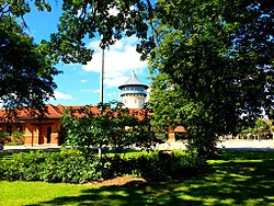 The Riverside Water Tower from Guthrie Park | |
 | |
| Location | Riverside, Illinois |
|---|---|
| Coordinates | 41°49′54″N 87°48′49″W / 41.83167°N 87.81361°WCoordinates: 41°49′54″N 87°48′49″W / 41.83167°N 87.81361°W |
| Area | 1,500 acres (610 ha) |
| Built | 1868 |
| Architect | Calvert Vaux; Frederick Law Olmsted; Frank Lloyd Wright |
| NRHP reference No. | 69000055 |
| Significant dates | |
| Added to NRHP | September 15, 1969[1] |
| Designated NHLD | August 29, 1970[2] |


The Riverside Historic District, also known as Riverside Landscape Architecture District, encompasses what is arguably one of the first planned communities in the United States. The district encompasses the majority of the village of Riverside, Illinois, a suburb just west of Chicago. It was planned and designed by Calvert Vaux and Frederick Law Olmsted, and features a number of architecturally distinguished buildings.[3]
History[]
According to "Riverside in 1871 With a Description of its Improvements", a booklet by The Riverside Improvement Company, The Riverside Improvement Company was established in April, 1869 to build a charming modern suburban neighborhood called "Riverside". About nine miles from Chicago, Riverside covers about 1,600 acres of land along the Des Plaines River. Frederick Law Olmsted, designer of Central Park, New York, furnished the plans for Riverside. Riverside village is unique among Chicago suburbs. Throughout the village, winding roads and green areas along the river create a park like setting.[4]
Water Tower in Riverside, IL is designed by Jenney, Schermerhor & Bogart, architects and Engineers. Like the Water Tower in Chicago, the Riverside water tower is also a well-known landmark in the area. It is both a water tank and a decorative element in the village-scape.
The Riverside district includes the streets, parkways, parklands, and historic gas street lighting in the area bounded by 26th St., Harlem and Ogden Aves., the Des Plaines River, and Forbes Rd.[3] Also included are the many homes and estates designed by architects such as Frank Lloyd Wright, Daniel Burnham, Louis Sullivan, William Le Baron Jenney, Frederick Clarke Withers, and Calvert Vaux.[5] Several homes, such as the F. F. Tomek House and the Coonley House, have individually received National Historic Landmark status.
All but about 100 acres (40 ha) of the village was designated a National Historic Landmark in 1970.[2][6]
See also[]
- List of National Historic Landmarks in Illinois
- National Register of Historic Places listings in Cook County, Illinois
References[]
- ^ "National Register Information System". National Register of Historic Places. National Park Service. January 23, 2007.
- ^ a b "Riverside Historic District". National Historic Landmark summary listing. National Park Service. Retrieved 2007-10-11.
- ^ a b National Register Information System. Accessed 2010-19-03.
- ^ [1]
- ^ The Village of Riverside. Accessed 2010-19-03.
- ^ Charles W. Snell (February 10, 1970). "National Register of Historic Places Inventory-Nomination: Riverside Historic District / Riverside Landscape Architecture District" (pdf). National Park Service. Cite journal requires
|journal=(help) and Accompanying 9 photos, possibly all from 1969. (1.33 MB)
External links[]
| Topics | |
|---|---|
| Lists by state |
|
| Lists by insular areas | |
| Lists by associated state | |
| Other areas | |
| Related | |
| |
- National Historic Landmarks in Illinois
- Riverside, Illinois
- Historic districts on the National Register of Historic Places in Illinois
- National Register of Historic Places in Cook County, Illinois