Rivière-Mistassini, Quebec
Rivière-Mistassini | |
|---|---|
Unorganized territory | |
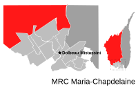 | |
 Rivière-Mistassini Location in Saguenay–Lac-Saint-Jean Quebec. | |
| Coordinates: 49°55′N 72°50′W / 49.917°N 72.833°WCoordinates: 49°55′N 72°50′W / 49.917°N 72.833°W[1] | |
| Country | |
| Province | |
| Region | Saguenay–Lac-Saint-Jean |
| RCM | Maria-Chapdelaine |
| Constituted | unspecified |
| Government | |
| • Federal riding | Roberval—Lac-Saint-Jean |
| • Prov. riding | Roberval |
| Area | |
| • Total | 18,753.80 km2 (7,240.88 sq mi) |
| • Land | 18,460.51 km2 (7,127.64 sq mi) |
| Population (2011)[3] | |
| • Total | 31 |
| • Density | 0.0/km2 (0/sq mi) |
| • Pop (2006–11) | |
| • Dwellings | 16 |
| Time zone | UTC-5 (EST) |
| • Summer (DST) | UTC-4 (EDT) |
| Area code(s) | 418 and 581 |

Rivière-Mistassini is an unorganized territory in the Canadian province of Quebec, located in the regional county municipality of Maria-Chapdelaine. The territory had a population of 31 as of the Canada 2011 Census, and covered a land area of 18,460.51 km2.
The eponymous Mistassini River has its source in the far northern part of the territory and entirely bisects it from north to south.
Demographics[]
Population trend:[4]
- Population in 2011: 31 (2006 to 2011 population change: 210.0%)
- Population in 2006: 10
- Population in 2001: 0
- Population in 1996: 0
- Population in 1991: 0
Private dwellings occupied by usual residents: 14 (total dwellings: 16)
References[]
- ^ Reference number 149743 of the Commission de toponymie du Québec (in French)
- ^ a b Ministère des Affaires municipales, des Régions et de l'Occupation du territoire - Répertoire des municipalités: Rivière-Mistassini
- ^ a b "Rivière-Mistassini census profile". 2011 Census data. Statistics Canada. Retrieved 2010-11-24.
- ^ Statistics Canada: 1996, 2001, 2006, 2011 census
Adjacent Municipal Subdivisions | ||||||||||||||||
|---|---|---|---|---|---|---|---|---|---|---|---|---|---|---|---|---|
| ||||||||||||||||
| Cities & Towns | |
|---|---|
| Municipalities | |
| Parishes | |
| Villages | |
| Unorganized territories |
|
| |
This Quebec location article is a stub. You can help Wikipedia by . |
Categories:
- Unorganized territories in Saguenay–Lac-Saint-Jean
- Maria-Chapdelaine Regional County Municipality
- Quebec geography stubs