Rivière Noire District
Black River
Rivière Noire | |
|---|---|
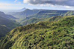 Black River Gorges | |
 Map of Mauritius island with Black River District highlighted | |
| Coordinates: 20°20′S 57°25′E / 20.333°S 57.417°ECoordinates: 20°20′S 57°25′E / 20.333°S 57.417°E | |
| Country | |
| Government | |
| • Type | District Council |
| • Chairman | Mr. Chetty Noël Doget Oxsinice |
| • Vice Chairman | Mrs. Papeche Nicole Marie Anne |
| Area | |
| • Total | 259 km2 (100 sq mi) |
| Population (2015)[2] | |
| • Total | 80,939 |
| • Density | 310/km2 (810/sq mi) |
| Time zone | UTC+4 (MUT) |

Rivière Noire (Mauritian Creole pronunciation: [ʁivjɛː nwɑː]) or Black River ([blak ɹivə]) is a district on the western side of the island of Mauritius. Rivière Noire translates to Black River. This region receives less rainfall than the others. The district has an area of 259 square kilometres (100 sq mi) and the population estimate was 80,939 as of 31 December 2015.[2] It is the third largest District of Mauritius in area, but the smallest in terms of population. The district is mostly rural, but it also include the western part of the city of Port Louis and western part of Quatre Bornes.[3]
History[]
This section is empty. You can help by . (July 2012) |
Places of interest[]
This section needs expansion. You can help by . (July 2012) |
Famous areas include Tamarin Falls and the Chamarel coloured earth. The name Black River derives from the fact that it is the driest district of the island. Flic en Flac is one of the most beautiful beaches on the island, and the longest.
Places[]
The Rivière Noire District includes different regions; however, some regions are further divided into different suburbs.[2][3]
- Bambous
- (Eastern part in Plaines Wilhems District)
- Chamarel (Eastern part in Savanne District)
- Flic-en-Flac
- Le Morne
- Port Louis (West)
- Quatre Bornes (West)
- Tamarin
Education[]
This section needs expansion. You can help by . (May 2015) |
Schools:
- École maternelle et primaire Paul et Virginie, a French international school, is in Tamarin.[4][5]
- La Gaulette State Secondary School, a state school providing co-education in La Gaulette Village
See also[]
References[]
| Wikimedia Commons has media related to Rivière Noire District. |
- ^ "Archived copy". Archived from the original on 4 April 2014. Retrieved 8 March 2014.CS1 maint: archived copy as title (link)
- ^ a b c Ministry of Finance & Economic Development (2016). "ANNUAL DIGEST OF STATISTICS 2015" (PDF). August. Government of Mauritius: 19. Retrieved 23 December 2016. Cite journal requires
|journal=(help) - ^ a b Statistic office of Mauritius (2011). "Housing and population Census 2011" (PDF). Government of Mauritius. Archived from the original (PDF) on 21 October 2013. Retrieved 29 July 2012. Cite journal requires
|journal=(help) - ^ "École maternelle et primaire Paul et Virginie." AEFE. Retrieved on May 4, 2015. "Adresse Route royale, 90901 Tamarin Ville: Tamarin Pays: Maurice"
- ^ "Accueil." École maternelle et primaire Paul et Virginie. Retrieved on May 4, 2015.
Places adjacent to Rivière Noire District | ||||||||||||||||
|---|---|---|---|---|---|---|---|---|---|---|---|---|---|---|---|---|
| ||||||||||||||||
| Subdivisions |
|  | ||||||||||||
|---|---|---|---|---|---|---|---|---|---|---|---|---|---|---|
| Politics |
| |||||||||||||
| Economy | ||||||||||||||
| Society |
| |||||||||||||
- Rivière Noire District
- Districts of Mauritius