Roßtal
Roßtal | |
|---|---|
 Town center of Roßtal with the Church of Saint Lawrence | |
 Coat of arms | |
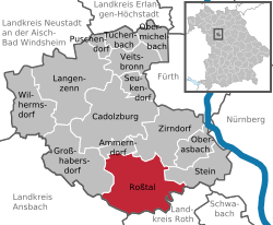
show Location of Roßtal within Fürth district | |
 Roßtal | |
| Coordinates: 49°24′N 10°53′E / 49.400°N 10.883°ECoordinates: 49°24′N 10°53′E / 49.400°N 10.883°E | |
| Country | Germany |
| State | Bavaria |
| Admin. region | Mittelfranken |
| District | Fürth |
| Subdivisions | 17 Ortsteile |
| Government | |
| • Mayor (2020–26) | Rainer Gegner[1] (SPD) |
| Area | |
| • Total | 44.40 km2 (17.14 sq mi) |
| Elevation | 373 m (1,224 ft) |
| Population (2020-12-31)[2] | |
| • Total | 10,127 |
| • Density | 230/km2 (590/sq mi) |
| Time zone | UTC+01:00 (CET) |
| • Summer (DST) | UTC+02:00 (CEST) |
| Postal codes | 90574 |
| Dialling codes | 09127 |
| Vehicle registration | FÜ |
| Website | www |


St. Lawrence Church in Roßtal
Roßtal is a market town in the district of Fürth, Bavaria, Germany. As of 2020 it had a population of 10,127.
Surrounded by beautiful forests, made accessible via many hiking and biking trails, Roßtal is a place for those who love nature and the outdoors.
References[]
- ^ Liste der ersten Bürgermeister/Oberbürgermeister in kreisangehörigen Gemeinden, Bayerisches Landesamt für Statistik, 15 July 2021.
- ^ "Tabellenblatt "Daten 2", Statistischer Bericht A1200C 202041 Einwohnerzahlen der Gemeinden, Kreise und Regierungsbezirke". Bayerisches Landesamt für Statistik (in German). June 2021.
External links[]
| Wikimedia Commons has media related to Roßtal. |
Official website (in German)
| show Towns and municipalities in Fürth (district) |
|---|
| show Authority control |
|---|
This Fürth district location article is a stub. You can help Wikipedia by . |
Categories:
- Municipalities in Bavaria
- Fürth (district)
- Middle Franconia geography stubs