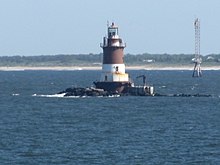
Romer Shoal Light
 | |
 | |
| Location | South of Ambrose Channel, New York Harbor |
|---|---|
| Coordinates | 40°30′46.823″N 74°0′48.672″W / 40.51300639°N 74.01352000°WCoordinates: 40°30′46.823″N 74°0′48.672″W / 40.51300639°N 74.01352000°W |
| Tower | |
| Constructed | 1838 |
| Foundation | Concrete / cast iron caisson |
| Construction | Cast iron |
| Height | 54 feet (16 m) |
| Shape | Frustum of a cone -- sparkplug |
| Markings | White bottom, red top including lantern |
| Heritage | National Register of Historic Places listed place |
| Fog signal | Horn: 2 every 30 s |
| Light | |
| First lit | 1898 (current tower) |
| Automated | 1966 |
| Focal height | 54 feet (16 m) |
| Lens | Fourth-order Fresnel lens (original), 7.5 inches (190 mm) (current) |
| Range | 15 nautical miles (28 km; 17 mi) |
| Characteristic | Flashing white twice 15 s |
Romer Shoal Light Station | |
| Nearest city | Highlands, New Jersey |
| Area | less than one acre |
| Built | 1898 |
| Architect | U.S. Lighthouse Board |
| MPS | Light Stations of the United States MPS |
| NRHP reference No. | 06001304[1] |
| NJRHP No. | 3713[2] |
| Significant dates | |
| Added to NRHP | January 24, 2007 |
| Designated NJRHP | August 16, 2006 |

Romer Shoal Light is a sparkplug lighthouse in Lower New York Bay, on the north edge of the Swash Channel, about 3⁄4 nautical mile (1.4 km; 0.86 mi) south of Ambrose Channel and 2+1⁄2 nautical miles (4.6 km; 2.9 mi) north of Sandy Hook, New Jersey, in the entrance to New York Harbor.[3][4][5][6] It is in New Jersey, very close to the border with New York.[7]
The shoal was named for the pilot boat William J. Romer which sank there in 1863.[5] The light was added to the National Register of Historic Places in 2007 as Romer Shoal Light Station.[1]
The Light was heavily damaged during Hurricane Sandy. The non-profit that has taken over stewardship of the Light is working with FEMA and private donors to preserve this national landmark.
References[]
- ^ a b "National Register Information System". National Register of Historic Places. National Park Service. March 13, 2009.
- ^ "New Jersey and National Registers of Historic Places - Monmouth County" (PDF). New Jersey Department of Environmental Protection - Historic Preservation Office. March 1, 2011. Archived from the original (PDF) on December 2, 2007. Retrieved April 26, 2011.
- ^ "Historic Light Station Information and Photography: New Jersey". United States Coast Guard Historian's Office. Archived from the original on 2017-05-01.
- ^ Light List, Volume I, Atlantic Coast, St. Croix River, Maine to Shrewsbury River, New Jersey (PDF). Light List. United States Coast Guard. 2009. p. 204.
- ^ a b Rowlett, Russ. "Lighthouses of the United States: New Jersey". The Lighthouse Directory. University of North Carolina at Chapel Hill.
- ^ NOAA Chart #12327 New York Harbor 1/40,000 2006
- ^ USGS quadrangle for cited location
| Wikimedia Commons has media related to Romer Shoal lighthouse. |

| Topics | |
|---|---|
| Lists by state |
|
| Lists by insular areas | |
| Lists by associated state | |
| Other areas | |
| Related | |
| |
| Authority control: Lighthouse identifiers |
|
|---|
This article relating to a United States lighthouse is a stub. You can help Wikipedia by . |
- Lighthouses completed in 1898
- Transportation buildings and structures in Monmouth County, New Jersey
- Lighthouses on the National Register of Historic Places in New Jersey
- National Register of Historic Places in Monmouth County, New Jersey
- New Jersey Register of Historic Places
- 1898 establishments in New Jersey
- New Jersey Registered Historic Place stubs
- United States lighthouse stubs