Rosebank station
Rosebank | |||
|---|---|---|---|
| Former Staten Island Railway station | |||
 Approximate site of former Rosebank station, with ramp for former bridge across former track | |||
| Station statistics | |||
| Borough | Staten Island | ||
| Locale | Rosebank | ||
| Coordinates | 40°36′53″N 74°04′13″W / 40.614639°N 74.070278°WCoordinates: 40°36′53″N 74°04′13″W / 40.614639°N 74.070278°W | ||
| Division | [1] | ||
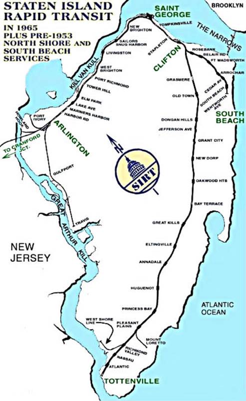
| Line | South Beach Branch | ||
| Services | none | ||
| Platforms | 2 side platforms | ||
| Tracks | 2 | ||
| Other information | |||
| Opened | March 8, 1886 | ||
| Closed | March 31, 1953 | ||
| Station succession | |||
| Next north | Bachmann | ||
| Next south | Belair Road | ||
| |||
| |||


Rosebank is a demolished station in the Rosebank neighborhood along the abandoned South Beach Branch of the Staten Island Railway. It had two tracks and two side platforms, and was located along Tilson Place between Virginia Avenue and St. Mary's Avenue.[2]
History[]
As part of a grade crossing elimination project on the South Beach Branch, the grade crossing at St. Mary's Avenue was eliminated, and the station was rebuilt in the fall of 1937. This structure remained in place until well after the branch's abandonment in 1953. There was an overpass at the new station connecting the two platforms. At Clifton Avenue, there was a pedestrian underpass which ran underground beneath the tracks that was built in 1937. This underpass was frequently used by students from Public School 13. The two buildings of P.S. 13 were later on replaced with one building, which stands on the South Beach Branch right-of-way.[2]
This station was abandoned when the SIRT discontinued passenger service on the South Beach Branch to Wentworth Avenue at midnight on March 31, 1953 because of city-operated bus competition.[3][4][5][6]
Previously, south of the station at Hylan Boulevard, there was an overpass, that has been filled in since the line was abandoned. The Virginia Avenue trestle was demolished in 1999.[2]
There is also discussion of building a station nearby on the SIR Main Line which would bridge the longest gap between two stations (Grasmere and Clifton). This proposed station could be named Rosebank.[7]
References[]
- ^ "Glossary". Second Avenue Subway Supplemental Draft Environmental Impact Statement (SDEIS) (PDF). 1. Metropolitan Transportation Authority. March 4, 2003. pp. 1–2. Archived from the original (PDF) on February 26, 2021. Retrieved January 1, 2021.
- ^ a b c "Gary Owen's SIRT Page". Gary Owen Land. March 31, 1953. Retrieved December 13, 2015.
- ^ "Gary Owen SIRT Page Part Two". Gary Owen Land. April 20, 1937. Retrieved December 13, 2015.
- ^ Pitanza, Marc (2015). Staten Island Rapid Transit Images of Rail. Arcadia Publishing. ISBN 978-1-4671-2338-9.
- ^ Drury, George H. (1994). The Historical Guide to North American Railroads: Histories, Figures, and Features of more than 160 Railroads Abandoned or Merged since 1930. Waukesha, Wisconsin: Kalmbach Publishing. pp. 312–314. ISBN 0-89024-072-8.
- ^ "The Old Order Passeth: Rails Surrender To Roads: Passenger Runs on Two Lines of SIRT Will End at Midnight". Staten Island Advance. March 31, 1953. Retrieved October 14, 2015.
- ^ DAnna, Ed A. (May 15, 2008). "A rail station for Rosebank?". Staten Island Advance. Retrieved January 28, 2010.
This Staten Island train station–related article is a stub. You can help Wikipedia by . |
- South Beach Branch stations
- 1886 establishments in New York (state)
- Railway stations in the United States opened in 1886
- Railway stations closed in 1953
- 1953 disestablishments in New York (state)
- New York City railway station stubs
- Staten Island building and structure stubs