Ross-on-Wye
This article needs additional citations for verification. (August 2009) |
| Ross-on-Wye | |
|---|---|
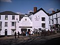
 Town centre, looking north from Market House | |
 Ross-on-Wye Location within Herefordshire | |
| Population | 10,700 (2011)[1] |
| OS grid reference | SO597241 |
| Unitary authority | |
| Ceremonial county | |
| Region | |
| Country | England |
| Sovereign state | United Kingdom |
| Post town | ROSS-ON-WYE |
| Postcode district | HR9 |
| Dialling code | 01989 |
| Police | West Mercia |
| Fire | Hereford and Worcester |
| Ambulance | West Midlands |
| UK Parliament | |

Ross-on-Wye (Welsh: Rhosan ar Wy) is a market town with a population of 10,582 according to the 2011 census, estimated at 11,309 in 2019.[2] It lies in south-eastern Herefordshire, England, on the River Wye and on the northern edge of the Forest of Dean.
History[]

The name "Ross" is derived from the Welsh or Celtic for a "promontory". It was renamed "Ross-on-Wye" in 1931 by the General Post Office, due to confusion with other places of the same or similar name such as Ross in Scotland).[3]
Ross-on-Wye promotes itself as "the birthplace of British tourism".[4] In 1745, the rector, Dr John Egerton, started taking friends on boat trips down the valley from his rectory at Ross. The Wye Valley's attraction was its river scenery, its precipitous landscapes, and its castles and abbeys, which were accessible to seekers of the "Picturesque". In 1782, William Gilpin's book Observations on the River Wye was published, the first illustrated tour guide to be published in Britain. Once it had appeared, demand grew so much that by 1808 there were eight boats making regular excursions down the Wye, most of them hired from inns in Ross and Monmouth. By 1850, more than 20 visitors had published their own accounts of the Wye Tour, and the area was established as a tourist destination.
Parish church[]

The 700-year-old parish church of St. Mary's[5] is the town's most prominent landmark, and its tall pointed spire is visible when approaching the town from all directions.[6] The church holds several distinctive tombs, one of which – that of (who died in 1530) – is one of the last great alabaster sculptures from the specialist masons of Nottingham, whose work was prized across medieval Europe. Rudhall was responsible for the repair of the almshouses, situated to the north west of the church, in 1575. Another tomb is of John Kyrle, a prominent figure in 18th-century Ross, whose name is now given to the town's secondary school and after whom one of the town's notable inns, The Man Of Ross, is also named.
United Reformed, Methodist and Baptist churches[]
The Methodist Church is Christ Church in Edde Cross Street.[7] The United Reformed Church congregation, part of the Herefordshire Group, is likewise at Christ Church.[8] The former United Reformed Church in Gloucester Road has now been converted into housing.
Ross Baptist Church is in Broad Street.[9] In 1731 the Baptists built Ryeford Chapel at Weston under Penyard, but by 1817 worshippers from Ross had decided to separate from the chapel. In 2017, the current Baptist church in Ross celebrated its 200th anniversary. In early 1818, 22 church members bought ground in Broad Street, on which it was intended to build a chapel with a graveyard behind. The first chapel was opened on 6 October 1818. By 1879 it had become dilapidated, however, with a leaking roof and a damp interior. It was demolished and a new one built in its place at a cost of £3,700. Various community events raised £537 towards the cost, but the remaining £3,163 was paid by Thomas Blake, a local philanthropist.[10]
Plague Cross[]

The Plague or Corpse Cross was erected in the churchyard of St Mary's in 1637 as a memorial to 315 residents who died in the town of the plague that year. They were buried nearby in a plague pit, at night and without coffins.[11]
By 1896, the Plague Cross had fallen into disrepair and the top was missing. It was later restored. Since 24 September 1997, it has been listed as a Grade II* edifice.[12]
The Prospect[]
The Prospect was created by John Kyrle. The land was rented by John Kyrle from the Marquess of Bath in 1696 and turned into a garden and walking area.[13] In 2008, after heavy rain, Roman remains were discovered and excavated under the site.[14] It now contains trees dedicated to local people, a VE Day Beacon and a War Memorial. Opposite the church, The Prospect is a public garden offering a view of the famous horseshoe bend in the River Wye and as far west as the Black Mountains.
Present day[]

The town is known for its locally owned shops, picturesque streets, and a market square with a market hall.
Thursday and Saturday markets are held at the red sandstone Market House building in the town centre.[15][16] This was built between 1650 and 1654 to replace a probably wooden Booth Hall. The upper storey now houses an Arts and Crafts centre.
The town cinema, "The Roxy" in Broad Street, closed in 1985[citation needed] and the site was bought by Gateway Supermarkets for development. The town still has a small theatre, The Phoenix, which shows films once a month and along with plays and other arts events.
The ruins of Wilton Castle, to the west of the town, have been restored and opened to visitors. The town has a number of sculptures by Walenty Pytel – the left bank of the Wye shows two of these. Despite the common belief that both depict swans, one in fact shows ducks.
Politics and representation[]
Most local government functions are vested in Herefordshire Council, the unitary authority covering the county. Ross Town Council, with 18 councillors, six each from the Ross North, West and East wards, has the powers of a parish council.[17] The Mayor is Councillor Daniel Lister. was merged into the civil parish on 1 April 2015.[18] As of the May 2019 local elections, the town council has a majority of Liberal Democrat councillors, with two Conservatives and three Independents.
The town belongs to Hereford and South Herefordshire parliamentary constituency, currently represented in the House of Commons by the Conservative MP Jesse Norman.
Transport[]

The former Ross-on-Wye railway station was at a junction on the Hereford, Ross and Gloucester Railway constructed to the north of the town. It was the terminus of the Ross and Monmouth Railway, which joined the Hereford, Ross and Gloucester just south of the station. Opened on 1 June 1855, the line was amalgamated with the Great Western Railway on 29 July 1862 and in 1869 converted from broad gauge to standard gauge in a five-day period. A line to Tewkesbury was authorised by Parliament in 1856, but never built.
Under the Beeching Axe, the lines to Ross closed in stages up to 1964.[19] The brick station has been demolished and the site redeveloped into an industrial estate, on which the brick goods and engine sheds still stand.[20]
The nearest railway station today is Ledbury on the Cotswold Line, but Gloucester has a better connection with Ross,[21] including a bus route to the town, and is a major interchange on the national rail network.
To the east of town is the end of the M50, sometimes called the Ross Spur or Ross Motorway, which links with the M5 motorway.
Climate[]
Ross-on-Wye experiences a typically British maritime climate, with cool summers and mild winters. A Met Office weather station provides long-term climate data for the town. Meteorological readings have been taken in Ross since 1858 and the Ross-on-Wye weather station holds some national records.[22]
| hideClimate data for Ross-on-Wye 67m asl, 1971–2000 | |||||||||||||
|---|---|---|---|---|---|---|---|---|---|---|---|---|---|
| Month | Jan | Feb | Mar | Apr | May | Jun | Jul | Aug | Sep | Oct | Nov | Dec | Year |
| Average high °C (°F) | 7.3 (45.1) |
7.7 (45.9) |
10.3 (50.5) |
12.9 (55.2) |
16.6 (61.9) |
19.3 (66.7) |
22.0 (71.6) |
21.5 (70.7) |
18.3 (64.9) |
14.2 (57.6) |
10.3 (50.5) |
8.1 (46.6) |
14.1 (57.4) |
| Average low °C (°F) | 1.8 (35.2) |
1.6 (34.9) |
3.2 (37.8) |
4.3 (39.7) |
7.1 (44.8) |
9.9 (49.8) |
12.1 (53.8) |
11.9 (53.4) |
9.7 (49.5) |
6.9 (44.4) |
4.0 (39.2) |
2.6 (36.7) |
6.3 (43.3) |
| Average precipitation mm (inches) | 80.7 (3.18) |
53.0 (2.09) |
51.2 (2.02) |
48.4 (1.91) |
49.2 (1.94) |
54.0 (2.13) |
34.8 (1.37) |
61.1 (2.41) |
63.7 (2.51) |
67.5 (2.66) |
64.5 (2.54) |
78.1 (3.07) |
706.2 (27.80) |
| Mean monthly sunshine hours | 49.9 | 67.5 | 107.3 | 149.4 | 189.4 | 188.1 | 211.4 | 193.4 | 137.1 | 98.6 | 67.2 | 45.0 | 1,504.3 |
| Source: Met Office[23] | |||||||||||||
Notable people[]
References appear on each person's page. In birth order:
- John Kyrle (1637–1724), philanthropist known as "the Man of Ross"
- James Cowles Prichard (1786–1848), scientist prominent in anthropology and psychiatry
- Frederick Gordon (1835–1904), hotelier
- William Partridge (1858–1930), soldier prominent in the 1878 Zulu war
- Arthur Pugh (1870–1955), President of the Trades Union Congress
- William Henry Squire (1871–1963), Royal Academy of Music member, cellist, composer and music professor
- Frank Andrews (1886–1944), international rugby union (Wales) and professional rugby league player
- Frederick Burrows (1887–1973), Governor of Bengal
- Juxon Barton (1891–1980), Governor of Fiji
- Noele Gordon (1919–1985), actress
- Yvonne Littlewood (born 1927), television producer
- Dennis Potter (1935–1994), dramatist
- Pete Overend Watts (1947–2017), member of the Mott the Hoople band
- Dale Griffin (1948–2016), member of Mott the Hoople
- Sarah Potter (born 1961), test cricketer
- Richard Hammond (born 1969), journalist and broadcaster
Twin towns[]
- Betzdorf, Germany
- Condé-sur-Noireau, France (since 1978)
- Namutumba, Uganda[24]
Gallery[]
The Man Of Ross inn

The Market House from the west
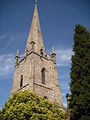
St Mary's Church spire

View of the town from the banks of the River Wye


See also[]
- Archenfield
- John Kyrle High School
- The Chase Hotel, Ross-On-Wye
References[]
- ^ "Town population 2011". Retrieved 20 November 2015.
- ^ City Population. Retrieved 17 February 2021.
- ^ Ross-on-Wye: History, Ross-on-Wye.com. Retrieved 23 November 2019
- ^ "Birthplace of British Tourism". wyevalleyaonb.org.uk.
- ^ St Mary Ross-on-Wye, Herefordshire:: OS grid SO5924 :: Geograph British Isles – photograph every grid square!
- ^ Ross-on-Wye from the Bypass:: OS grid SO5924 :: Geograph British Isles – photograph every grid square!
- ^ "Christ Church". Herefordshiremethodists.org.uk. Retrieved 21 January 2020.
- ^ [1]
- ^ "Ross Baptist Church; Find us". Retrieved 21 January 2020.
- ^ [2]
- ^ "Local Monuments". Ross-on-Wye.com. Retrieved 9 May 2008.
- ^ https://historicengland.org.uk/listing/the-list/list-entry/1016128
- ^ "The Prospect – The Garden". Ross-on-Wye. Retrieved 15 June 2013.
- ^ "Ross-on-Wye Development – Prospect – Summary". Ross-on-wye.com. Retrieved 15 June 2013.
- ^ Ross on Wye, Market hall:: OS grid SO5924:: Geograph British Isles – photograph every grid square!
- ^ Market House, Ross-on-Wye:: OS grid SO5924 :: Geograph British Isles – photograph every grid square!
- ^ [3]
- ^ "The County of Herefordshire District Council (Reorganisation of Community Governance) (Ross-on-Wye) (No. 2) Order 2014" (PDF). Lgbce. Retrieved 10 March 2018.
- ^ "Herefordshire Through Time – Welcome". Smr.herefordshire.gov.uk. Retrieved 15 June 2013.
- ^ "The Railway in Ross – The Station". Ross-on-Wye. Retrieved 15 June 2013.
- ^ [4]
- ^ "Ross-on-Wye - Weather Station". www.ross-on-wye.com.
- ^ "Caldecott 1961–90 averages". UKMO. Archived from the original on 23 May 2012. Retrieved 17 January 2018.
- ^ "Twinning". Ross-on-Wye Town Council. Retrieved 20 June 2010.
External links[]
| Wikimedia Commons has media related to Ross-on-Wye. |
- Ross-on-Wye Town Council
 Ross-on-Wye travel guide from Wikivoyage
- Littlebury's Directory, 1876-7
- Ross-on-Wye at Curlie
| show Authority control |
|---|
- Ross-on-Wye
- Market towns in Herefordshire
- Towns in Herefordshire
- Towns of the Welsh Marches
- River Wye
- Civil parishes in Herefordshire