Rouergue

Rouergue (French pronunciation: [ʁwɛʁɡ]; Occitan: Roergue) is a former province of France, corresponding roughly with the modern department of Aveyron. Its historical capital is Rodez.[1] It is bounded on the north by Auvergne, on the south and southwest by Languedoc, on the east by Gévaudan and on the west by Quercy.[2]
During the Middle Ages Rouergue changed hands a number of times, its rulers including England (due to the Treaty of Brétigny in 1360), Armagnac and Languedoc.
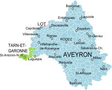
Rouergue became a department in 1790, and was renamed Aveyron after the principal river flowing through it. Upon creation of the department of Tarn-et-Garonne in 1808, the canton of Saint-Antonin-Noble-Val was detached from the western extremity of Aveyron and transferred to the new department.
The province of Rouergue had a land area of 9,007 km² (3,478 sq. miles). At the 1999 census there were 269,774 inhabitants on the territory of the province of Rouergue, for a density of only 30 inh. per km² (78 inh. per sq. mile). The largest urban areas are Rodez, with 38,458 inhabitants in 1999; Millau, with 22,840 inhabitants in 1999; Decazeville, with 17,044 inhabitants in 1999; and Villefranche-de-Rouergue, with 12,561 inhabitants in 1999.
See also[]
- Counts of Rouergue
- Counts of Toulouse
References[]
- ^ Rouergue at the Larousse online encyclopedia
- ^ Chisholm, Hugh, ed. (1911). . Encyclopædia Britannica. 23 (11th ed.). Cambridge University Press. p. 770.
Coordinates: 44°20′N 2°37′E / 44.33°N 2.62°E

| hide Authority control | |
|---|---|
| General | |
| National libraries | |
- Rouergue
- Former provinces of France
- Guyenne
- Geography of Aveyron
- Geography of Lot (department)
- Geography of Tarn-et-Garonne
- History of Occitanie
- History of Aveyron
- History of Lot (department)
- History of Tarn-et-Garonne