Rouissat
Rouissat
اﻟﺮوﻳﺴﺎت | |
|---|---|
Town | |
 | |
 Rouissat | |
| Coordinates: 31°55′N 5°21′E / 31.917°N 5.350°E | |
| Country | |
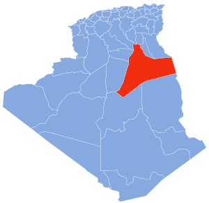
| Province | Ouargla Province |
| District | Ouargla District |
| Elevation | 138 m (453 ft) |
| Population (2008)[1] | |
| • Total | 58,112 |
| Time zone | UTC+1 (CET) |

Rouissat is a town and commune in Ouargla District, Ouargla Province, Algeria. According to the 2008 census it has a population of 58,112,[1] up from 37,814 in 1998,[2] and a population growth rate of 4.5%.[1] It is within the urban area of the provincial capital Ouargla, lying just to the south of the city center.
Localities[]
The commune is composed of eight localities:[3]
- Rouissat
- El Hadeb
- Babanou
- Sidi Naïmi
- Ziaïna
- Sidi mbarek
- Sokra
- lachoual
References[]
- ^ Jump up to: a b c "Population: Béchar Wilaya" (PDF) (in French). Office National des Statistiques Algérie. Retrieved 24 February 2013.
- ^ "Algeria Communes". Statoids. Retrieved 8 March 2013.
- ^ "Décret n° 84-365, fixant la composition, la consistance et les limites territoriale des communes. Wilaya d'El Oued" (PDF) (in French). Journal officiel de la République Algérienne. 19 December 1984. p. 1551. Archived from the original (PDF) on 2 March 2013 or before. Retrieved 2 March 2013. Check date values in:
|archivedate=(help)
Neighbouring towns and cities
| show Places adjacent to Rouissat |
|---|
Coordinates: 31°55′N 5°21′E / 31.917°N 5.350°E
This article about a location in Ouargla Province is a stub. You can help Wikipedia by . |
Categories:
- Communes of Ouargla Province
- Algeria geography stubs