Sława
Sława | |
|---|---|
 Market Square (Rynek) | |
 Coat of arms | |
 Sława | |
| Coordinates: 51°53′N 16°5′E / 51.883°N 16.083°E | |
| Country | |
| Voivodeship | Lubusz |
| County | Wschowa |
| Gmina | Sława |
| Area | |
| • Total | 14.31 km2 (5.53 sq mi) |
| Population (2019-06-30[1]) | |
| • Total | 4,321 |
| • Density | 300/km2 (780/sq mi) |
| Time zone | UTC+1 (CET) |
| • Summer (DST) | UTC+2 (CEST) |
| Postal code | 67-410 |
| Area code(s) | +48 68 |
| Climate | Dfb |
| Website | http://www.slawa.pl |

Sława ([ˈswava]; German: Schlawa, 1937–45: Schlesiersee)[2] is a town in Wschowa County, Lubusz Voivodeship, Poland, with 4,321 inhabitants (2019).
History[]
The area was part of Poland after the creation of the state in the 10th century. Later on, as a result of the fragmentation of Poland, it was part of the Polish Piast-ruled Duchy of Głogów until 1468. The town was mentioned in a document from 1312.
Between 1871 and 1945 the town was part of Germany and was renamed Schlesiersee in 1937 during the Nazi campaign of erasing placenames of Polish origin.[2] The original Polish name Sława was restored after Nazi Germany's defeat in World War II, when the town once again became part of Poland.
Twin towns – sister cities[]
See twin towns of Gmina Sława.
Gallery[]

Sława Lake

Saint Michael Archangel church

Municipal office
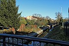
Czernica river in Sława


References[]
- ^ "Population. Size and structure and vital statistics in Poland by territorial division in 2019. As of 30th June". stat.gov.pl. Statistics Poland. 2019-10-15. Retrieved 2020-03-23.
- ^ Jump up to: a b M. Kaemmerer (2004). Ortsnamenverzeichnis der Ortschaften jenseits von Oder u. Neiße (in German). ISBN 3-7921-0368-0.
| Wikimedia Commons has media related to Sława. |

Coordinates: 51°53′N 16°05′E / 51.883°N 16.083°E
| Authority control |
|---|
This Wschowa County location article is a stub. You can help Wikipedia by . |
- Cities and towns in Lubusz Voivodeship
- Wschowa County
- Province of Silesia
- Province of Lower Silesia
- Wschowa County geography stubs