Saal an der Saale
Saal a.d.Saale | |
|---|---|
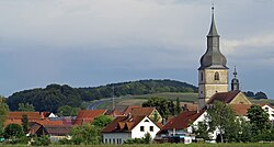
 Saal an der Saale seen from the west | |
 Coat of arms | |
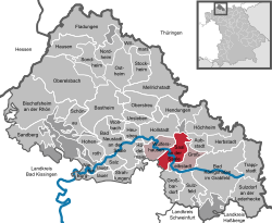
show Location of Saal a.d.Saale within Rhön-Grabfeld district | |
 Saal a.d.Saale | |
| Coordinates: 50°19′N 10°22′E / 50.317°N 10.367°ECoordinates: 50°19′N 10°22′E / 50.317°N 10.367°E | |
| Country | Germany |
| State | Bavaria |
| Admin. region | Unterfranken |
| District | Rhön-Grabfeld |
| Municipal assoc. | Saal an der Saale |
| Government | |
| • Mayor (2020–26) | Cornelia Dahinten[1] |
| Area | |
| • Total | 21.57 km2 (8.33 sq mi) |
| Elevation | 254 m (833 ft) |
| Population (2020-12-31)[2] | |
| • Total | 1,517 |
| • Density | 70/km2 (180/sq mi) |
| Time zone | UTC+01:00 (CET) |
| • Summer (DST) | UTC+02:00 (CEST) |
| Postal codes | 97633 |
| Dialling codes | 09762 |
| Vehicle registration | NES |
| Website | www.saal-saale.de |
Saal an der Saale is a municipality in the district of Rhön-Grabfeld in Bavaria in Germany. It is situated on the river Fränkische Saale. The municipality consists the two townships Saal an der Saale and Waltershausen.

Castle Waltershausen
Ever since the 1978 "Gemeindegebietsreform" it has been the seat of the joint administration of these independent communities: Wülfershausen, Großeibstadt, and Saal an der Saale. The entire administrative area is home to roughly 4200 inhabitants as of 2008.
References[]
- ^ Liste der ersten Bürgermeister/Oberbürgermeister in kreisangehörigen Gemeinden, Bayerisches Landesamt für Statistik, 15 July 2021.
- ^ "Tabellenblatt "Daten 2", Statistischer Bericht A1200C 202041 Einwohnerzahlen der Gemeinden, Kreise und Regierungsbezirke". Bayerisches Landesamt für Statistik (in German). June 2021.
Categories:
- Municipalities in Bavaria
- Rhön-Grabfeld
- Lower Franconia geography stubs


