Sabanetas, Ponce, Puerto Rico
Sabanetas | |
|---|---|
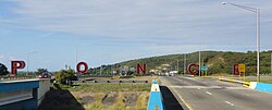 The iconic Letras de Ponce in barrio Sabanetas | |
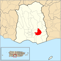 Location of Barrio Sabanetas within the municipality of Ponce shown in red | |
 Sabanetas Location of Puerto Rico | |
| Coordinates: 18°01′08″N 66°34′52″W / 18.018955°N 66.58113°WCoordinates: 18°01′08″N 66°34′52″W / 18.018955°N 66.58113°W[1] | |
| Commonwealth | |
| Municipality | |
| Area | |
| • Total | 2.79 sq mi (7.2 km2) |
| • Land | 2.74 sq mi (7.1 km2) |
| • Water | 0.05 sq mi (0.1 km2) |
| Elevation | 121 ft (37 m) |
| Population (2010) | |
| • Total | 5,534 |
| • Density | 2,034.6/sq mi (785.6/km2) |
| Source: 2010 Census | |
| Time zone | UTC−4 (AST) |

Sabanetas (Barrio Sabanetas) is one of the 31 barrios of the municipality of Ponce, Puerto Rico. Along with Magueyes, Tibes, Portugués, Montes Llanos, Machuelo Arriba, Maragüez, and Cerrillos, Sabanetas is one of the municipality's eight rural interior barrios. The name of this barrio is of native Indian origin.[3] It was founded in 1831.[4]
Location[]
Sabanetas is located in the southern section of the municipality, east of the traditional city center at Plaza Las Delicias. The toponomy, or origin of the name, is one that describes an open valley covered by grasslands and few, if any, trees.[5]
Boundaries[]
It is bounded on the North by barrio Cerrillos, in the South by barrios Bucaná and Vayas, in the West by barrios Machuelo Abajo and San Anton, and in the East by barrios Coto Laurel and Vayas.

Features and demographics[]
Sabanetas has 2.7 square miles (7.0 km2) of land area and 0.1 square miles (260,000 m2) of water area. In 2000, the population of Sabanetas was 6,420. The population density in Sabanetas was 2,352 persons per square mile.[6]
In 2010, the population of Sabanetas was 5,534 persons, and it had a density of 2,034.6 persons per square mile.[7]
The communities of Campo Alegre, Alta Vista, Villa Flores, and Sabanetas proper are located in barrio Sabanetas.
Major roads serving Barrio Sabanetas are PR-1, PR-52, and PR-10.
The highest point in Barrio Sabanetas is Cerro Los Negrones which stands at 397 feet.[8]
Landmarks[]
The Sabanetas Industrial Park is located in Sabanetas, as is Central Mercedita.
See also[]
References[]
- ^ a b "US Gazetteer 2019". US Census. US Government.
- ^ U.S. Geological Survey Geographic Names Information System: Sabanetas barrio
- ^ Sunny A. Cabrera Salcedo. Hacia un Estudio Integral de la Toponimia del Municipio de Ponce, Puerto Rico. Ph. D. dissertation. May 1999. University of Massachusetts Amherst. Graduate School. Department of Spanish and Portuguese. Page 54.
- ^ Barrios de Ponce. Antepasados Esclavos.(From: Pedro Tomás de Córdoba. Memorias geográficas, históricas, económicas y estadísticas de la Isla de Puerto Rico.) Retrieved 28 November 2014.
- ^ Government of the Municipality of Ponce. Periodico "El Señorial". Special issue: Carnaval Ponceño 2013. February 2013. Page 17. Ponce, Puerto Rico.
- ^ City Melt Retrieved 14 February 2010.
- ^ Puerto Rico:2010:population and housing unit counts.pdf (PDF). U.S. Dept. of Commerce, Economics and Statistics Administration, U.S. Census Bureau. 2010.
- ^ Maptest. Archived 2010-02-18 at the Wayback Machine Government of the Commonwealth of Puerto Rico. General Purpose Population Data, Census 2000. Unidad de Sistemas de Información Geográfica, Área de Tecnología de Información Gubernamental, Oficina de Gerencia y Presupuesto. Gobierno de Puerto Rico. Retrieved 10 November 2011.
External links[]
 Media related to Sabanetas at Wikimedia Commons
- Barrio Sabanetas
- 1831 establishments in Puerto Rico