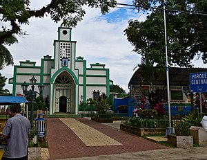
Sacacoyo
This article needs additional citations for verification. (October 2017) |
Sacacoyo | |
|---|---|
Municipality | |
 | |
 Sacacoyo Location in El Salvador | |
| Coordinates: 13°44′N 89°28′W / 13.733°N 89.467°WCoordinates: 13°44′N 89°28′W / 13.733°N 89.467°W | |
| Country | |
| Department | La Libertad |
| Elevation | 2,172 ft (662 m) |

Sacacoyo is a municipality in the La Libertad department of El Salvador.
History[]
The name Sacacoyo comes from the Nahua phrase "En el camino de coyotes y zacate" (in the path of coyotes and grass) [1] In 1890, Sacacoyo had a population of 1,870 people. In 1905, Sacacoyo was combined as part of Tepecoyo, but on 11 May 1907 was recreated as Sacacoyo by legislative decree.
Geography[]
Administrative divisions:[2]
Sacacoyo is made up of three cantons:
- Ateos (historically Atehuan)
- Buena Vista
- La Montañita
References[]
- ^ "Archived copy". Archived from the original on 2007-11-07. Retrieved 2012-09-14.CS1 maint: archived copy as title (link)
- ^ "Archived copy". Archived from the original on 2008-06-19. Retrieved 2012-09-14.CS1 maint: archived copy as title (link)
Capital: Santa Tecla | ||
| Municipalities | 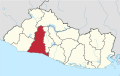 | |
This El Salvador location article is a stub. You can help Wikipedia by . |
Categories:
- Municipalities of the La Libertad Department (El Salvador)
- El Salvador geography stubs