Sacramento, California
Sacramento, California | |
|---|---|
State capital city | |
| City of Sacramento | |
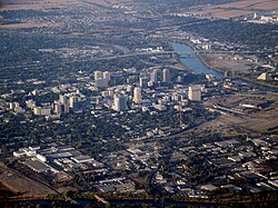
    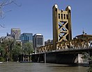  From the top to right: Downtown Sacramento; California State Capitol, Crocker Art Museum; Downtown Sacramento; Tower Bridge and the Sacramento Riverfront; California Supreme Court | |
 Flag  Seal | |
| Nickname(s): "Sactown", "Sac", "City of Trees","River City", "Camellia City", "America's Most Diverse City" | |
| Motto(s): Latin: Urbs Indomita (English: "Indomitable City") | |
 Location within Sacramento County in California | |
 Sacramento Location within the United States | |
| Coordinates: 38°34′54″N 121°29′40″W / 38.58167°N 121.49444°WCoordinates: 38°34′54″N 121°29′40″W / 38.58167°N 121.49444°W | |
| Country | United States |
| State | California |
| County | Sacramento
|
| Region | Sacramento Valley |
| CSA | Sacramento-Roseville |
| MSA | Sacramento–Roseville–Arden-Arcade |
| Incorporated | February 27, 1850[1] |
| Chartered | 1920[2] |
| Named for | Sacrament of the Holy Eucharist |
| Government | |
| • Type | City Council[3] |
| • Body | Sacramento City Council |
| • Mayor | Darrell Steinberg (D[4]) |
| • City Council[4] | show
Council Members |
| Area | |
| • City | 99.77 sq mi (258.41 km2) |
| • Land | 97.68 sq mi (253.00 km2) |
| • Water | 2.09 sq mi (5.41 km2) 2.19% |
| Elevation | 30 ft (9 m) |
| Population | |
| • City | 524,943 |
| • Rank | 35th in the United States 6th in California |
| • Density | 5,374.11/sq mi (2,074.87/km2) |
| • Metro | 2,397,382 (26th) |
| Demonym(s) | Sacramentan |
| Time zone | UTC−8 (PST) |
| • Summer (DST) | UTC−7 (PDT) |
| ZIP codes | 942xx, 958xx |
| Area code | 916 and 279 |
| Interstates | |
| U.S. routes | |
| State highways | |
| Website | cityofsacramento |


Sacramento (/ˌsækrəˈmɛntoʊ/ SAK-rə-MEN-toh; Spanish: [sakɾaˈmento], Spanish for ''sacrament'') is the capital city of the U.S. state of California and the seat and largest city of Sacramento County. Located at the confluence of the Sacramento and American Rivers in Northern California's Sacramento Valley, Sacramento's 2020 population of 524,943[7] makes it the sixth-largest city in California and the ninth-largest capital in the United States.[10][11] Sacramento is the seat of the California Legislature and the Governor of California, making it the state's political center and a hub for lobbying and think tanks. It features the California State Capitol Museum.
Sacramento is also the cultural and economic core of the Sacramento metropolitan area, which at the 2020 census had a population of 2,397,382,[8] the fifth-largest in California.[12]
Before the arrival of the Spanish, the area was inhabited by the historic Nisenan, Maidu, and other indigenous peoples of California. Spanish cavalryman Gabriel Moraga surveyed and named the Río del Santísimo Sacramento (Sacramento River) in 1808, after the Blessed Sacrament, referring to the Eucharist in the Catholic Church. In 1839, Juan Bautista Alvarado, Mexican governor of Alta California, granted the responsibility of colonizing the Sacramento Valley to Swiss-born Mexican citizen John Augustus Sutter, who subsequently established Sutter's Fort and the settlement at the Rancho Nueva Helvetia. Following the American Conquest of California and the 1848 Treaty of Guadalupe-Hidalgo, the waterfront developed by Sutter began to be developed, and incorporated in 1850 as the City of Sacramento.
Sacramento is the fastest-growing major city in California,[13] owing to its status as a notable financial center on the West Coast and as a major educational hub, home of California State University, Sacramento and University of California, Davis. Similarly, Sacramento is a major center for the California healthcare industry, as the seat of Sutter Health, the world-renowned UC Davis Medical Center, and the UC Davis School of Medicine. It is a tourist destination, featuring the California Museum, Crocker Art Museum, California State Railroad Museum, California Hall of Fame, and Old Sacramento State Historic Park. Sacramento International Airport, located northwest of the city, is the city's major airport.
Sacramento is known for its evolving contemporary culture, and is dubbed the most "hipster city" in California.[14][15] In 2002, the Harvard University Civil Rights Project conducted for Time magazine ranked Sacramento as "America's Most Diverse City".[16]
History[]
Spanish Empire 1776–1821
United Mexican States 1839–1848
California Republic 1846
United States 1848–present
Pre-Columbian period[]
Nisenan (Southern Maidu), Modoc, and Plains Miwok Native Americans lived in the area for perhaps thousands of years. Unlike the settlers who would eventually make Sacramento their home, these Native Americans left little evidence of their existence. Their diet was dominated by acorns taken from the plentiful oak trees in the region and by fruits, bulbs, seeds, and roots gathered throughout the year.
Spanish period[]

In 1808, the Spanish explorer Gabriel Moraga encountered and named the Sacramento Valley and the Sacramento River. A Spanish writer with the Moraga expedition wrote: "Canopies of oaks and cottonwoods, many festooned with grapevines, overhung both sides of the blue current. Birds chattered in the trees and big fish darted through the pellucid depths. The air was like champagne, and (the Spaniards) drank deep of it, drank in the beauty around them. "¡Es como el sagrado sacramento! (It's like the Blessed Sacrament.)"[17] The valley and the river were then christened after the "Most Holy Sacrament of the Body and Blood of Christ," referring to the Catholic sacrament of the Eucharist.
Mexican period[]

John Sutter, Sr. first arrived in the area on August 13, 1839, at the divergence of the American and Sacramento Rivers with a Mexican land grant of 50,000 acres (20,000 ha). The next year, his party and he established Sutter's Fort, a massive adobe structure with walls 18 feet (5.5 m) high and three feet (0.91 m) thick.[18]
Representing Mexico, Sutter Sr. called his colony New Helvetia, a Swiss-inspired name, and was the political authority and dispenser of justice in the new settlement. Soon, the colony began to grow as more and more pioneers headed west. Within just a few short years, Sutter Sr. had become a grand success, owning a 10-acre (4.0 ha) orchard and a herd of 13,000 cattle. Fort Sutter became a regular stop for the increasing number of immigrants coming through the valley. In 1847, Sutter Sr. received 2,000 fruit trees, which started the agriculture industry in the Sacramento Valley. Later that year, Sutter Sr. hired James Marshall to build a sawmill so he could continue to expand his empire,[18] but unbeknownst to many, Sutter Sr.'s "empire" had been built on thin margins of credit.[19]
American period[]

In 1848, when James W. Marshall discovered gold at Sutter's Mill in Coloma (some 50 mi or 80.5 km northeast of the fort), numerous gold-seekers came to the area, increasing the population. In August 1848, Sutter Sr's son, John Sutter Jr., arrived to assist his father in reducing his indebtedness. The Sutters struggled to contain the effects of thousands of new gold miners and prospectors in the area, many who squatted on unwatched portions of the vast Sutter lands, or stole various unattended Sutter properties or belongings if they could. For Sutter, his employee's discovery of gold in the area turned out to be more of a personal 'bane' for him.
By December 1848, John Sutter Jr., in association with Sam Brannan, began laying out the City of Sacramento, 2 miles (3.2 km) south of his father's settlement of New Helvetia. This venture was undertaken against the wishes of Sutter Sr, but the father, being deeply in debt, was in no position to stop the venture. For commercial reasons, the new city was named "Sacramento City" after the Sacramento River. Sutter Jr. and Brannon hired topographical engineer William H. Warner to draft the official layout of the city, which included 26 lettered and 31 numbered streets (today's grid from C St. to Broadway and from Front St. to Alhambra Blvd.) Relations between Sutter and his son became embittered after Sacramento became an overnight commercial success. (Sutter's Fort, Mill, and the town of Sutterville, all founded by John Sutter Sr, eventually failed).
Residents of Sacramento adopted a city charter in 1849, which was recognized by the state legislature in 1850. Sacramento is the oldest incorporated city in California, incorporated on February 27, 1850.[20]
During the early 1850s, the Sacramento valley was devastated by floods, fires and cholera epidemics. Despite this, the new city's location just downstream from the Mother Lode in the Sierra Nevada proved irresistible, and it grew rapidly, attracting a population of 10,000.


The California State Legislature, with the support of Governor John Bigler, moved to Sacramento in 1854. The capital of California under Spanish (and, subsequently, Mexican) rule had been Monterey, where, in 1849, the first Constitutional Convention and state elections were held. The convention decided San Jose would be the new state's capital. After 1850, when California's statehood was ratified, the legislature met in San Jose until 1851, Vallejo in 1852, and Benicia in 1853, before moving to Sacramento. In the Sacramento Constitutional Convention of 1879, Sacramento was named as the permanent state capital.
The Classical Revival-style California State Capitol, similar to the national Capitol, was started in 1860 and completed in 1874. In 1861, the legislative session was moved to the Merchants Exchange Building in San Francisco for one session because of massive flooding in Sacramento. From 1862 to 1868, part of the Leland Stanford Mansion was used for the governor's offices during Stanford's tenure as the Governor; and the legislature met in the Sacramento County Courthouse. The legislative chambers were first occupied in 1869, while construction continued around them.
With its new status and strategic location, Sacramento quickly prospered. It was designated as the western terminus of the Pony Express. Later it became a terminus of the First Transcontinental Railroad, which began construction in Sacramento in 1863 and was financed by "The Big Four"—Mark Hopkins, Charles Crocker, Collis P. Huntington, and Leland Stanford. Both the American and especially Sacramento rivers were key elements in the economic success of the city. Sacramento effectively controlled commerce on these rivers, and public works projects were funded through taxes levied on goods unloaded from boats and loaded onto rail cars in the historic Sacramento Rail Yards.
In 1850 and again in 1861, Sacramento residents suffered a completely flooded town. In 1861, Governor Leland Stanford, who was inaugurated in early January 1861, traveled to his inauguration in a rowboat. The event was held not too far from his house in town on N Street. The flood waters were so bad, the legend says, that when Stanford returned to his house, he had to enter into it through the second floor window.
From 1862 until the mid-1870s, Sacramento raised the level of its downtown by building reinforced brick walls on its downtown streets, and filling the resulting street walls with dirt. The previous first floors of buildings became the basements, with open space between the street and the building, previously the sidewalk, now at the basement level. Over the years, many of these underground spaces have been filled or destroyed by subsequent development. But it is still possible to view portions of the "Sacramento Underground".
During the 1850s the city was consolidated with the County of Sacramento.[21]
Modern era[]

The city's current charter was adopted by voters in 1920.[22] As a charter city, Sacramento is exempt from many laws and regulations passed by the state legislature. The city has expanded continuously over the years. The 1964 merger of the City of North Sacramento with Sacramento substantially increased its population, and large annexations of the Natomas area eventually led to significant population growth throughout the 1970s, 1980s, and 1990s.
Sacramento County (along with a portion of adjacent Placer County) is served by a customer-owned electric utility, the Sacramento Municipal Utility District (SMUD). Sacramento voters approved the creation of SMUD in 1923.[23] In April 1946, after 12 years of litigation, a judge ordered Pacific Gas & Electric to transfer title of Sacramento's electric distribution system to SMUD. Today SMUD is the sixth-largest public electric utility in the U.S., and is a leader for innovative programs and services, including the development of clean fuel resources, such as solar power.[24]

The year following the creation of SMUD, 1924, brought several events in Sacramento: Standard Oil executive Verne McGeorge established McGeorge School of Law, American department store Weinstock & Lubin opened a new store at 12th and K street, the US$2 million Senator Hotel was opened, Sacramento's drinking water became filtered and treated drinking water, and Sacramento boxer Georgie Lee fought Francisco Guilledo, a Filipino professional boxer known as Pancho Villa, at L Street Auditorium on March 21.[25]
Early in World War II, the Sacramento Assembly Center (also known as the Walerga Assembly Center) was established to house Japanese Americans forcibly "evacuated" from the West Coast under Executive Order 9066. The camp was one of fifteen temporary detention facilities where over 110,000 Japanese Americans, two-thirds of them U.S. citizens, were held while construction on the more permanent War Relocation Authority camps was completed. The assembly center was built on the site of a former migrant labor camp, and inmates began arriving from Sacramento and San Joaquin Counties on May 6, 1942. It closed after only 52 days, on June 26, and the population of 4,739 was transferred to the Tule Lake concentration camp. The site was then turned over to the Army Signal Corps and dedicated as Camp Kohler.

After the war and the end of the incarceration program, returning Japanese Americans were often unable to find housing and so 234 families temporarily lived at the former assembly center. Camp Kohler was destroyed by a fire in December 1947, and the assembly center site is now part of the Foothill Farms-North Highlands subdivision.[26] The Sacramento-Yolo Port District was created in 1947, and ground was broken on the Port of Sacramento in 1949.
On June 29, 1963, with 5,000 spectators waiting to welcome her, the Motor Vessel Taipei Victory arrived.[27] The Nationalist Chinese flagship docked at the Port of Sacramento, being first ocean-going vessel in Sacramento since the steamship Harpoon in 1934.
In 1967, Ronald Reagan became the last Governor of California to live permanently in the city. The 1980s and 1990s saw the closure of several local military bases: McClellan Air Force Base, Mather Air Force Base, and Sacramento Army Depot. In 1980, there was another flood.
In spite of military base closures and the decline of agricultural food processing, Sacramento has continued to experience population growth in recent years. Primary sources of population growth are an influx of residents from the nearby San Francisco Bay Area, as well as immigration from Asia and Latin America. In 1985, Hugh Scrutton, a 38-year-old Sacramento, California, computer store owner, was killed by a nail-and-splinter-loaded bomb placed in the parking lot of his store. In 1996, his death was attributed to the Unabomber, Theodore Kaczynski.
After acquiring the majority stake in the Sacramento Kings, the team's new owner, Vivek Ranadivé with the help of the city, agreed to build a new Arena in the downtown area. With a final estimated cost of $558.2 million, Sacramento's Golden 1 Center opened on September 30, 2016.
Geography[]

According to the United States Census Bureau, the city covers 100.1 square miles (259 km2). 97.81% of it is land, and 2.19% of it is water.
Depth to groundwater is typically about 30 feet (9 m). Much of the land to the west of the city (in Yolo County) is permanently reserved for a vast flood control basin (the Yolo Bypass), due to the city's historical vulnerability to floods. As a result, the contiguous urban area sprawls only four miles (6 km) west of downtown (as West Sacramento, California) but 30 miles (48 km) northeast and east, into the Sierra Nevada foothills, and 10 miles (16 km) to the south into valley farmland.
The city is at the confluence of the Sacramento River and the American River, and has a deep-water port connected to the San Francisco Bay by a channel through the Sacramento–San Joaquin River Delta. It is the shipping and rail center for the Sacramento Valley.[28]
Trees[]
Sacramento has long been known as the "City of Trees" owing to its abundant urban forest. The first recorded use of the term was in 1855, and it was popular by the early 20th century. It was not always so: it was at first called the “City of Plains” because of the lack of trees, but soon afterwards there were cottonwood trees planted, and eucalyptus varieties were imported in order to dry out swampland. Later, locust trees, and willows were planted along streets, then elms, then palm trees, then fruit trees in the late 1910s.[29] It was the first US city to be designated a City of Trees by the Arbor Day Foundation in 1978.[30]
In the early 21st century, the tree cover is well above that of the average tree cover of other major cities in the United States and the rest of the world, with the main species the London plane. Other species are being introduced to increase diversity and to help cope with the effects of climate change on vegetation in the future.[29] Treepedia, a project run by MIT using Google Maps’ street-view data to calculate tree coverage in cities, ranked Sacramento the greenest city of 15 studied in the US, and third globally, after Vancouver and Singapore.[31]
A prominent water tower bore the slogan "City of Trees" until 2017, when it was repainted with the words "America’s Farm-to-Fork Capital" (referring to the farm-to-fork movement, which promotes consumption of locally-grown food). After 4,000 displeased citizens signed a petition protesting the change, officials agreed to include both slogans on the water tower.[32]
Cityscape[]

City neighborhoods[]


The city groups most of its neighborhoods into four areas:
- Area One: Alkali Flat, Boulevard Park, Campus Commons, Sacramento State, Dos Rios Triangle, Downtown, East Sacramento, Fab Forties, Mansion Flats, Marshall School, Midtown, New Era Park, McKinley Village, Newton Booth, Old Sacramento, Poverty Ridge, Richards, Richmond Grove, River Park, Elmhurst, , Southside Park.[33]
- Area Two: Airport, Carleton Tract, Freeport Manor, Golf Course Terrace, Greenhaven, Curtis Park, Hollywood Park, Land Park, Little Pocket, Mangan Park, Meadowview, Parkway, Pocket, Sacramento City College, South Land Park, Valley Hi / North Laguna, Z'Berg Park.[34]
- Area Three: , , , , Colonial Heights, Colonial Manor, Curtis Park, Elmhurst, Fairgrounds, Florin, , , , , , , , , Oak Park, Packard Bell, , Southeast Village, Tahoe Park, Tahoe Park East, Tahoe Park South, Tallac Village, Vintage Park, Churchill Downs, and Woodbine.[35]
- Area Four: Ben Ali, Del Paso Heights, Gardenland, Hagginwood, McClellan Heights West, Natomas (north, south, west), North Sacramento, Northgate, Robla, Swanston Estates, Terrace Manor, Valley View Acres, and Woodlake.[36]
Additional prominent regions and neighborhoods in the city include American River Parkway, Arden-Arcade, Arden Fair, Cal Expo, Capital Avenue, Coffing, College Glen, College Greens, Cordova, Creekside, East Fruitridge, Elder Creek, Elkhorn, Elvas, Erikson Industrial Park, Excelsior Sunrise, Foothill Farms, Franklin, Frates Ranch, Gateway Center, Gateway West, Glenwood Meadows, Hansen Park, Heritage Park, Johnson Business Park, Johnson Heights, Mayhew, Metro Center, Mills, Natomas Corporate Center, Natomas Creek, Natomas Crossing, Natomas Park, Newton Booth, Noralto, Northpointe, Norwood, Oak Knoll, Old North Sacramento, Parker Homes, Point West, Raley Industrial Park, Regency Park, Richardson Village, Richmond Grove, Rosemont, Sierra Oaks, Sports Complex, Strawberry Manor, Sundance Lake, Swanston Palms, Town and Country Village, Upper Land Park, Village 5, Village 7, Village 12, Village 14, Village Green, Walerga, Walsh Station, West Del Paso Heights, Westlake, Willowcreek, Wills Acres, Winn Park, Woodside and Youngs Heights.[37][38]
Climate[]
| showClimate data for Sacramento, California (Sacramento Executive Airport), 1981–2010 normals, extremes 1941–present[a] |
|---|
| showClimate data for Sacramento 5 ESE, California (Sacramento State[43]), 1981–2010 normals, extremes 1877–present) |
|---|
Sacramento has a hot-summer Mediterranean climate (Köppen Csa), characterized by very hot, dry summers and mild to cool winters with occasional rainfall. The wet season is generally October through April, though there may be a day or two of light rainfall in June or September. The normal annual mean temperature is 61.0 °F (16.1 °C), with the monthly daily average temperature ranging from 46.4 °F (8.0 °C) in December to 75.5 °F (24.2 °C) in July.[45] Summer heat is sometimes moderated by a sea breeze known as the "delta breeze" which comes through the Sacramento–San Joaquin River Delta from the San Francisco Bay, and temperatures cool down sharply at night.

The foggiest months are December and January. Tule fog can be extremely dense, lowering visibility to less than 100 feet (30 m) and making driving conditions extremely hazardous. Chilling tule fog events have been known to last for several consecutive days or weeks. During Tule fog events, temperatures do not exceed 50 °F (10 °C).
Snowfall is rare in Sacramento, which is only 25 ft (7.6 m) above sea level. In the downtown area, only three significant snow accumulations have occurred since 1900, the last one being in 1976.[46] During especially cold winter and spring storms, intense showers do occasionally produce a significant amount of hail, which can create hazardous driving conditions. Snowfall in the city often melts upon ground contact, with traceable amounts occurring in some years. Significant annual snow accumulations occur in the foothills 40 mi (64 km) east of the city, which had brief and traceable amounts of snowfall in January 2002, December 2009, and February 2011.[47][48] The greatest snowfall ever recorded in Sacramento was 3 inches (8 cm) on January 5, 1888.

On average, there are 73 days where the high exceeds 90 °F (32 °C), and 14 days where the high exceeds 100 °F (38 °C); On the other extreme, there are 15 days where the temperature does not exceed 50 °F (10 °C), and 15 freezing nights per year.[45] Official temperature extremes range from 18 °F (−8 °C) on December 22, 1990, to 115 °F (46 °C) on June 15, 1961;[45] a station around 5 mi (8.0 km) east-southeast of the city dipped to 17 °F (−8 °C) on December 11, 1932.[49]
The average annual precipitation is 18.52 inches (470 mm). On average, precipitation falls on 60 days each year in Sacramento, and nearly all of this falls during the winter months. Average January rainfall is 3.67 in (93 mm), and measurable precipitation is rare during the summer months. In February 1992, Sacramento had 16 consecutive days of rain, resulting in an accumulation of 6.41 in (163 mm) for the period. On rare occasions, monsoonal moisture surges from the Desert Southwest can bring upper-level moisture to the Sacramento region, leading to increased summer cloudiness, humidity, and even light showers and thunderstorms. Monsoon clouds do occur, usually during late July through early September. Sacramento is the second most flood susceptible city in the United States after New Orleans.[50]
Sacramento has been noted as being the sunniest location on the planet for four months of the year, from May through August. It holds the distinction as the sunniest month, in terms of percent possible sunshine, of anywhere in the world; July in Sacramento averages 14 hours and 12 minutes of sunshine per day, amounting to approximately 100% of possible sunshine.[51]
Demographics[]
| Historical population | |||
|---|---|---|---|
| Census | Pop. | %± | |
| 1850 | 6,820 | — | |
| 1860 | 13,785 | 102.1% | |
| 1870 | 16,283 | 18.1% | |
| 1880 | 21,420 | 31.5% | |
| 1890 | 26,386 | 23.2% | |
| 1900 | 29,282 | 11.0% | |
| 1910 | 44,696 | 52.6% | |
| 1920 | 65,908 | 47.5% | |
| 1930 | 93,750 | 42.2% | |
| 1940 | 105,958 | 13.0% | |
| 1950 | 137,572 | 29.8% | |
| 1960 | 191,667 | 39.3% | |
| 1970 | 257,105 | 34.1% | |
| 1980 | 275,741 | 7.2% | |
| 1990 | 369,365 | 34.0% | |
| 2000 | 407,018 | 10.2% | |
| 2010 | 466,488 | 14.6% | |
| 2020 | 524,943 | 12.5% | |
| U.S. Decennial Census[52] 2010–2020[7] | |||
In 2002, the Civil Rights Project at Harvard University conducted for Time magazine named Sacramento "America's Most Diverse City."[16] The U.S. Census Bureau also groups Sacramento with other U.S. cities having a "high diversity" rating of the diversity index.[53] Moreover, Sacramento is one of the most well-integrated U.S. cities, having a relatively high level of ethnic and racial heterogeneity within its neighborhoods.[54]
2010 census[]
The 2010 United States Census[55] reported Sacramento had a population of 466,488. The population density was 4,660.0 people per square mile (1,799.2/km2).
| hideRacial composition | 2010[56] | 1990[57] | 1970[57] | 1940[57] |
|---|---|---|---|---|
| White | 45.0% | 60.1% | 81.5% | 94.2% |
| —Non-Hispanic | 34.5% | 53.4% | 71.4%[58] | n/a |
| African American | 14.6% | 15.3% | 10.7% | 1.4% |
| Hispanic or Latino (of any race) | 26.9% | 16.2% | 11.0%[58] | n/a |
| Asian | 18.3% | 15.0% | 6.5% | 4.3% |
The racial makeup of Sacramento was:[55]
- 231,131 (45.0%) White
- 74,989 (14.6%) African American
- 93,993 (18.3%) Asian (4.2% Chinese, 3.3% Hmong, 2.8% Filipino, 1.6% Indian, 1.4% Vietnamese, 1.2% Laotian, 1.2% Japanese, 0.3% Pakistani, 0.3% Korean, 0.3% Thai, 0.2% Cambodian)
- 7,191 (1.4%) Pacific Islander (0.6% Fijian, 0.2% Tongan, 0.2% Samoan)
- 5,649 (1.1%) Native American
- 63,176 (12.3%) other races
- 36,467 (7.1%) from two or more races.
Hispanic or Latino of any race were 138,165 persons (26.9%); 22.6% of Sacramento's population is of Mexican heritage which amounts to over four-fifths of the city's Hispanic/Latino diaspora, 0.7% Puerto Rican, 0.5% Salvadoran, 0.2% Guatemalan, and 0.2% Nicaraguan.[59] Non-Hispanic Whites were 34.5% of the population in 2010,[56] down from 71.4% in 1970.[57]


The Census reported 458,174 people (98.2% of the population) lived in households, 4,268 (0.9%) lived in non-institutionalized group quarters, and 4,046 (0.9%) were institutionalized. The recent[when?] housing crash has not impacted these numbers.[citation needed]
There were 174,624 households, out of which 57,870 (33.1%) had children under the age of 18 living in them, 65,556 (37.5%) were opposite-sex married couples living together, 27,640 (15.8%) had a female householder with no husband present, 10,534 (6.0%) had a male householder with no wife present. There were 13,234 (7.6%) unmarried opposite-sex partnerships, and 2,498 (1.4%) same-sex married couples or partnerships. 53,342 households (30.5%) were made up of individuals, and 14,926 (8.5%) had someone living alone who was 65 years of age or older. The average household size was 2.62. There were 103,730 families (59.4% of all households); the average family size was 3.37.
Sacramento has one of the highest LGBT populations per capita, ranking seventh among major American cities, and third in California behind San Francisco and slightly behind Oakland, with roughly 10% of the city's total population identifying themselves as gay, lesbian, or bisexual.[60]
The age distribution of the city was follows: 116,121 people (24.9%) were under the age of 18, 52,438 people (11.2%) aged 18 to 24, 139,093 people (29.8%) aged 25 to 44, 109,416 people (23.5%) aged 45 to 64, and 49,420 people (10.6%) who were 65 years of age or older. The median age was 33.0 years. For every 100 females, there were 94.9 males. For every 100 females age 18 and over, there were 92.2 males.
There were 190,911 housing units at an average density of 1,907.1 per square mile (736.3/km2), of which 86,271 (49.4%) were owner-occupied, and 88,353 (50.6%) were occupied by renters. The homeowner vacancy rate was 2.8%; the rental vacancy rate was 8.3%. 231,593 people (49.6% of the population) lived in owner-occupied housing units and 226,581 people (48.6%) lived in rental housing units.
Economy[]


The Sacramento metropolitan area is the fifth largest in California after the Los Angeles metropolitan area, the San Francisco Bay Area, the Inland Empire, and the San Diego metropolitan area, and is the 27th largest in the United States.[12]
Sutter Health, Blue Diamond Growers, Aerojet Rocketdyne, Teichert, and The McClatchy Company are among the companies based in Sacramento.
The Port of Sacramento has been plagued with operating losses in recent years and faces bankruptcy. This severe loss in business is due to the heavy competition from the Port of Stockton, which has a larger facility and a deeper channel. As of 2006, the city of West Sacramento took responsibility for the Port of Sacramento. During the Vietnam War era, the Port of Sacramento was the major terminus in the supply route for all military parts, hardware and other cargo going to Southeast Asia.
Top employers[]
As of 2019,[61] the top employers in the County of Sacramento were:
| # | Employer | Employees |
|---|---|---|
| 1 | State of California | 76,131 |
| 2 | UC Davis Health | 12,674 |
| 3 | Kaiser Permanente | 11,404 |
| 4 | Sacramento County | 11,330 |
| 5 | Sutter Health | 8,809 |
| 6 | Dignity Health/Catholic Healthcare West | 7,069 |
| 7 | Elk Grove Unified School District | 6,381 |
| 8 | Intel | 6,200 |
| 9 | City of Sacramento | 5,700 |
| 10 | Sacramento City Unified School District | 5,000 |
| 11 | San Juan Unified School District | 4,700 |
Culture[]
Performing arts[]

The Sacramento Ballet, Sacramento Philharmonic Orchestra and the Sacramento Opera perform at the Community Center Theater.
There are several major theater venues in Sacramento. The Sacramento Convention Center Complex governs both the Community Center Theatre and Memorial Auditorium. The consists of the Wells Fargo Pavilion, built in 2003 atop the old Music Circus tent foundations, the McClatchy Mainstage and the Pollock Stage, originally built as a television studio and renovated at the same time the Pavilion was built. These smaller venues seat 300 and 90, offering a more intimate presentation than the 2300-seat Pavilion. The newest venue in the city, the , consists of the 365-seat Sutter Theatre for Children and the Mainstage, seating 250.
Professional theatre is represented in Sacramento by a number of companies. Broadway Sacramento and its locally produced Summer stock theatre, , lures many directors, performers, and artists from New York and Los Angeles to work alongside a large local staff at the Wells Fargo Pavilion. During the fall, winter and spring seasons Broadway Sacramento brings bus and truck tours to the Community Center Theater. Resident at the for the remainder of the year (from September to May), the Sacramento Theatre Company prepares to celebrate its 75th season, beginning in the Fall of 2019. In addition to a traditional regional theatre fare of classical plays and musicals, the Sacramento Theatre Company has a large School of the Arts with a variety of opportunities for arts education. The B Street Theatre, having completed its 2018 move into the new , continues its pursuit of producing smaller and more intimate professional works for families and children. Rounding out the professional companies is , which performed aboard the Delta King until the end of the 2010–2011 season and soon took up residence at its own venue along the J-Street corridor.
The Sacramento area has one of the largest collection of community theatres in California. Some of these include the Thistle Dew Dessert Theatre and Playwrights Workshop, Davis Musical Theatre Co., El Dorado Musical Theatre, Runaway Stage Productions, River City Theatre Company, Flying Monkey Productions, The Actor's Theatre, KOLT Run Productions, Kookaburra Productions, Big Idea Theatre, Celebration Arts, Lambda Player, Light Opera Theatre of Sacramento, Synergy Stage and the historic Eagle Theatre. The Sacramento Shakespeare Festival provides entertainment under the stars every summer in William Land Park. Many of these theatres compete annually for the Elly Awards overseen by The Sacramento Area Regional Theatre Alliance or SARTA.[62]
Visual arts[]
The Sacramento Metropolitan Arts Commission is an organization that was established as the Sacramento arts council in 1977 to provide several arts programs for the city. These include Art in Public Places, Arts Education, Grants and Cultural Programs, Poet Laureate Program, Arts Stabilization Programs and Other Resources and opportunities.
Sacramento Second Saturday Art Walk is a program of local art galleries that stay open into the late evenings every second Saturday of each month, providing a unique experience for the local population as well as tourists to view original art and meet the artists themselves.
Museums[]
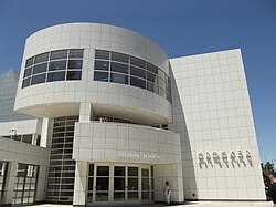
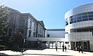
Sacramento has several major museums. The Crocker Art Museum is the oldest public art museum west of the Mississippi River. On July 26, 2007, the museum broke ground for an expansion that more than tripled the museum's floor space. The modern architecture is very different from the museum's original Victorian style building. Construction was completed in 2010.
Also of interest is the Governor's Mansion State Historic Park, a large Victorian Mansion which was home to 14 of California's Governors. The Leland Stanford Mansion State Historic Park, which was completely restored in 2006, serves as the State's official address for diplomatic and business receptions. Guided public tours are available. The California Museum for History, Women, and the Arts, home of the California Hall of Fame, is a cultural destination dedicated to telling the rich history of California and its unique influence on the world of ideas, innovation, art and culture. The museum educates tens of thousands of school children through inspiring programs, sharing with world visitors California's rich art, history and cultural legacy through dynamic exhibits, and serving as a public forum and international meeting place.
The California State Railroad Museum in Old Sacramento has historical exhibits and live steam locomotives that patrons may ride. The California Automobile Museum, just south of Old Sacramento, is filled with automotive history and vehicles from 1880 to 2006 and is the oldest non-profit automotive museum in the West. The mission of it is to preserve, promote, and teach automotive culture and its influence on our lives—past, present and future. In addition, the Sacramento History Museum, in the heart of Old Sacramento, focuses on the history of Sacramento from the region's pre-Gold Rush history through the present day.
There is a Museum Day held in Sacramento every year, when 26 museums in the greater Sacramento area offer free admission. The 2009 Sacramento Museum Day brought out more than 80,000 people, the largest number the event has gathered. Sacramento Museum Day is held every year on the first Saturday of February.
Music[]

Tower Records was started and based in Sacramento until its closing.[63] Rappers C-Bo, Marvaless, Lunasicc, and more recently rappers like Mozzy and Chuuwee are among those native to the area. Classical music is widely available. The Sacramento Philharmonic Orchestra, the Sacramento Baroque Soloists, the Sacramento Choral Society & Orchestra, the Sacramento Youth Symphony, the Sacramento Master Singers, the Sacramento Children's Chorus, and the Camellia Symphony each present a full season of concerts.
Each year, the city hosts the Sammies, the Sacramento Music Awards. Sacramento also has a reputation as a center for Dixieland jazz, because of the Sacramento Jazz Jubilee which is held every Memorial Day weekend. Events and performances are held in multiple locations throughout the city. Each year thousands of jazz fans from all over the world visit for this one weekend.
A growing number of rock, hardcore and metal bands hail from the Sacramento area, including Tesla, , Deftones, Papa Roach, Will Haven, Trash Talk,[64][65][66] Dance Gavin Dance, A Lot Like Birds, Far, CAKE, !!!, Oleander and Steel Breeze; plus some other famous musicians like record producer and recording artist Charlie Peacock, , of Social Distortion and Craig Chaquico of Jefferson Starship. Along with these bands, the Aftershock Festival has been held at Discovery Park since 2012.
Scottish pop band Middle of the Road sang kindly of Sacramento in their 1972 European hit song "Sacramento". Experimental groups such as Hella, Death Grips, and Tera Melos also come out of Sacramento.
Film[]
Sacramento is home to the Sacramento French Film Festival, a cultural event held every year in July that features U.S. premieres of French films and classic masterpieces of French cinema and the Sacramento Japanese Film Festival,[67] also held in July. In addition, Sacramento is home to the Trash Film Orgy, a summer film festival celebrating the absurd, B-movies, horror, monster, and exploitation films.[68] Founded in 2007, the Sacramento Horror Film Festival showcases feature-length and short films as well as live musical and theatrical performances in the horror and macabre genres.[69]
Of note, Sacramento has been home to various actors, including Eddie Murphy, who resided in the Riverlake community of Pocket-Greenhaven with his then wife Nicole Mitchell Murphy, a fashion model and Sacramento native. It is also the home of director Greta Gerwig, whose solo directorial debut Lady Bird is set in Sacramento.
Cuisine[]

In 2012, Sacramento started the marketing campaign as "America's Farm-to-Fork Capital" due to Sacramento's many restaurants that source their food from the numerous surrounding farms.[70] The city has an annual Farm-to-Fork festival that showcases various grocers and growers in the industry. In 2012, The Kitchen was nominated for Outstanding Restaurant by the James Beard Foundation.[71] It continues to excel, earning the AAA's Five Diamond dining award since 2011.[72] Sacramento is home to well-known cookbook authors, Biba Caggiano of Biba's Restaurant and Mai Pham of Lemongrass and Star Ginger.[73]
Sacramento is also known for its beverage culture, with keystone events that include Cal Expo's Grape and Gourmet, Sacramento Beer Week, and Sacramento Cocktail Week. Its growing beer scene is evident, with over 60 microbreweries in the region as of 2017.[74] Some local brews include Track 7 Brewing Company, Big Stump Brew Co, Oak Park Brewing Co., and Sactown Union Brewery. Numerous beer festivals around the region highlight both local and visitor beers. In addition to festivals in Elk Grove,[75] Davis, Roseville, Placerville,[76] and Woodland,[77] Sacramento hosts the annual California Beer Craft Summit, an exposition dedicated to the art of brewing. The summit also hosts the largest beer festival on the West Coast, featuring over 160 breweries in downtown Sacramento.[78]
Sacramento's contemporary culture is reflected in its coffee. An "underrated coffee city",[79] Sacramento has above-average marks for local coffee.[80] The city has numerous community roasters and coffee shops. Examples include Temple Coffee, Insight Coffee Roasters, Old Soul Co., Chocolate Fish Roasters, Naked Lounge, Pachamama Coffee Cooperative, and Identity Coffees. In addition to local brands, the region offers other chains such as Starbucks, Peet's Coffee & Tea, and Philz Coffee.
LGBTQ[]
Sacramento has one of the highest LGBT populations per capita, ranking seventh among major American cities, and third in California behind San Francisco and slightly behind Oakland, with roughly 10% of the city's total population identifying themselves as gay, lesbian, transgender, or bisexual.[60] Lavender Heights is the hub for LGBTQ activities in the city and is a centrally located district in Midtown Sacramento centered within and around K & 20th streets. The area owes its name to the high number of gay-owned homes and businesses residing there. The area is also home to many of the city's LGBTQ inclusive music and arts festivals, including the Second Saturday Block Party from May to September.
Old Sacramento[]

The oldest part of the town besides Sutter's Fort is Old Sacramento, which consists of cobbled streets and many historic buildings, several from the 1850s and 1860s. Buildings have been preserved, restored, or reconstructed, and the district is now a substantial tourist attraction, with rides on steam-powered historic trains and horse-drawn carriages.
The historic buildings include the Lady Adams Building, built by the passengers and ship's carpenters of the ship Lady Adams.[81] Having survived the Great Conflagration of November 1852, it is the oldest surviving building in Sacramento other than Sutter's Fort.[81]
Another surviving landmark is the B.F. Hastings building, built in 1853. The early home of the California Supreme Court and the location of the office of Theodore Judah, it also was the western terminus of the Pony Express.[82]
The "Big Four Building," built in 1852, was home to the offices of Collis Huntington, Mark Hopkins, Leland Stanford, and Charles Crocker. The Central Pacific Railroad and Southern Pacific Railroad were founded there. The original building was destroyed in 1963 for the construction of Interstate 5, but was re-created using original elements in 1965. It is now a National Historic Landmark. Also of historic interest is the Eagle Theatre (Sacramento, California), a reconstruction of California's first permanent theatre in its original location.
Chinatown[]

The Opium Wars of the 1840s and 1850s, along with the Gold Rush, brought many Chinese people to California. Most arrived at San Francisco, which was then the largest city in California and known as "Dà Bù" (Chinese: 大埠; Jyutping: daai6 fau6). Some eventually came to Sacramento, then the second-largest city in California and consequently called "Yee Fow" (Chinese: 二埠; Jyutping: ji6 fau6). Today the city is known as "萨克拉门托" (pinyin: Sàkèlāméntuō) by Mainland Chinese and as "沙加緬度" (pinyin: Shājiāmiǎnduó) by Taiwanese.
Sacramento's Chinatown was on "I" Street from Second to Sixth Streets. At the time, this area of "I" Street was considered a health hazard because, lying within a levee zone, it was lower than other parts of the city, which were situated on higher land. Throughout Sacramento's Chinatown history, there were fires, acts of discrimination, and prejudicial legislation such as the Chinese Exclusion Act that was not repealed until 1943. The mysterious fires were thought to be set off by those who did not take a liking to the Chinese working class.[83] Ordinances on what was viable building material were set into place to try to get the Chinese to move out. Newspapers such as The Sacramento Union wrote stories at the time that portrayed the Chinese in an unfavorable light to inspire ethnic discrimination and drive the Chinese away. As the years passed, a railroad was created over parts of the Chinatown, and further policies and laws would make it even harder for Chinese workers to sustain a living in Sacramento.
While most of Sacramento's Chinatown has now been razed, a small Chinatown mall remains as well as a museum dedicated to the history of Sacramento's Chinatown and the contributions Chinese Americans have made to the city. Amtrak sits along what was part of Sacramento's Chinatown "I" Street.[84][85]
Sports[]

Sacramento is home to one major league sports team – the Sacramento Kings of the National Basketball Association. The Kings came to Sacramento from Kansas City in 1985. On January 21, 2013, a controlling interest of the Sacramento Kings was sold to hedge fund manager Chris Hansen, who intended to move the franchise to Seattle for the 2013–2014 NBA season and rename the team the Seattle SuperSonics.[86] Sacramento Mayor Kevin Johnson fought the move, forming an ownership group led by Vivek Ranadive to keep the Kings in Sacramento. On May 16, 2013, the NBA Board of Governors voted 22–8 to keep the Kings in Sacramento.[87]
Sacramento has two other professional teams. Sacramento Republic FC began play in April 2014 at Hughes Stadium before a sellout crowd of 20,231, setting a USL Pro regular-season single game attendance record.[88][89] They now play in Papa Murphy's Park. Republic FC won the USL championship in their first season. In October 2019, Republic FC's Major League Soccer expansion bid was approved; the team was expected to begin MLS play in the 2022 season,[90] until being delayed by COVID-19 to the 2023 season.[91] However, as of February 26, 2021, the bid is on indefinite hiatus.[92] In 2000, AAA minor league baseball returned to Sacramento with the Sacramento River Cats, an affiliate of the San Francisco Giants and formerly an affiliate of the Oakland Athletics. The River Cats play at Sutter Health Park, in West Sacramento.
Sacramento is the former home of two professional basketball teams. The Sacramento Heatwave of the American Basketball Association previously played in the Sacramento area until 2013. Sacramento was also formerly home to the now defunct Sacramento Monarchs of the WNBA. The Monarchs were one of the eight founding members of the WNBA in 1997 and won the WNBA Championship in 2005, but folded in November 2009.
| Club | League | Sport | Venue | Attendance | Established | Championships |
|---|---|---|---|---|---|---|
| Sacramento Kings | NBA | Basketball | Golden 1 Center | 18,500 | 1923 (1985) | 1 NBA, 2 NBL (as Rochester Royals) |
| Sacramento Republic FC | USL Championship | Soccer | Papa Murphy's Park | 11,800 | 2012 | 1 USL Pro |
| Sacramento River Cats | Triple-A West | Baseball | Sutter Health Park | 14,200 | 1978 (2000) | 3 Triple-A titles, 5 League titles |
Sacramento has frequently hosted the NCAA Men's Outdoor Track and Field Championship as well as the 1st and 2nd rounds of the NCAA Men's Division I Basketball Championship. The California International Marathon (est. 1983) attracts a field of international elite runners who vie for a share of the $50,000 prize purse. The fast course is popular for runners seeking to achieve a Boston Marathon qualifying time and fitness runners.
Parks and recreation[]

Sacramento boasts an extensive park system consisting of over 5,000 acres (2,023 ha) of parkland and recreation centers.[93] The city features a collection of smaller parks in the downtown districts, including Crocker Park, Pioneer Landing and Southside Park. Popular parks outside the central core include American River Parkway which spans 23 miles along the American River, and William Land Park.
In its 2013 ParkScore ranking, The Trust for Public Land reported Sacramento was tied with San Francisco and Boston for having the 3rd best park system among the 50 most populous U.S. cities.[94] ParkScore ranks city park systems by a formula that analyzes the city's median park size, park acres as percent of city area, the percent of residents within a half-mile of a park, spending of park services per resident, and the number of playgrounds per 10,000 residents.
Sacramento is a hotbed for high school rugby. Jesuit High is the recent defending national champion (winning five times in total). Their arch-rival school Christian Brothers came in second nationwide. Burbank, Del Campo, and Vacaville have also placed well in the national competition over the years. The Sacramento Valley High School Rugby Conference hosts the largest and arguably deepest preseason youth and high school rugby tournament in America.

Sacramento hosts some recreational facilities and events. The Jedediah Smith Memorial Trail that runs between Old Sacramento and Folsom Lake grants access to the American River Parkway, a natural area that includes more than 5,000 acres (20 km2) of undeveloped land. It attracts cyclists and equestrians from across the state. The California State Fair is held in Sacramento each year at the end of the summer, ending on Labor Day. In 2010, the State Fair moved to July. More than one million people attended this fair in 2001.
Among other recreational options in Sacramento is Discovery Park, a 275-acre (1.1 km2) park studded with stands of mature trees and grasslands. This park is situated where the American River flows into the Sacramento River.
In amateur sports, Sacramento claims many prominent Olympians such as Mark Spitz, Debbie Meyer (6 time gold medalist in for US swimming), Mike Burton, Summer Sanders (Gold medalist in swimming, and trained in childhood by Debbie Meyer at Rio Del Oro Racquet Club), Jeff Float (all swimming), and Billy Mills (track). Coach Sherm Chavoor founded his world-famous Arden Hills Swim Club just east of the city and trained Burton, Spitz and others.
Government[]


The Government of Sacramento operates as a charter city (as opposed to a general law city) under the Charter of the City of Sacramento. The elected government is composed of the Sacramento City Council with 8 city council districts and the Mayor of Sacramento, which operate under a mayor-council government. In addition, there are numerous departments and appointed officers such as the City Manager, Sacramento Police Department (SPD), the Sacramento Fire Department (SFD), City Clerk, City Attorney, and City Treasurer. As of 2016, the mayor is Darrell Steinberg and the council members are Angelique Ashby, Allen Warren, Jeff Harris, Steve Hansen, Jay Schenirer, Rich Jennings, and Larry Carr.[4] The City of Sacramento is part of Sacramento County, for which the government of Sacramento County is defined and authorized under the California Constitution, California law, and the Charter of the County of Sacramento.[95]
As the capital city of California, Sacramento is home to the Government of California. The California State Capitol is the seat of the Governor of California and the California State Legislature, and the city is home to numerous California state agencies. The Supreme Court of California is headquartered in San Francisco, but maintains one of its two branch offices in Sacramento, where it shares a courtroom with the Court of Appeal for the Third Appellate District.
State and Federal representation[]
In the California State Senate, Sacramento is the heart of the 6th district, represented by Democrat Richard Pan.[96] In the California State Assembly, it is split between the 7th Assembly District, represented by Democrat Kevin McCarty, and the 9th Assembly District, represented by Democrat Jim Cooper.[97]
In the United States House of Representatives, Sacramento forms the majority of the California's 6th congressional district, represented by Democrat Doris Matsui.[98]
Political history[]
Sacramento has been carried by the Democrats in each of the last six presidential elections, with the last four Democratic campaigns each exceeding 70% of the vote.
| Year | Democratic | Republican | Third Parties |
|---|---|---|---|
| 2020[99] | 75.10% 168,776 | 22.44% 50,430 | 2.45% 5,511 |
| 2016[100] | 73.82% 127,245 | 20.01% 34,486 | 6.18% 10,645 |
| 2012[101] | 72.95% 115,979 | 24.55% 39,029 | 2.50% 3,966 |
| 2008[102] | 74.09% 120,961 | 26.47% 43,214 | 2.01% 3,281 |
| 2004[103] | 64.38% 90,952 | 34.61% 48,892 | 1.01% 1,433 |
Education[]
Higher education[]


The Sacramento area hosts a wide variety of higher educational opportunities. There are two major public universities, many private institutions, community colleges, vocational schools, and McGeorge School of Law.
Sacramento is home to Sacramento State (California State University, Sacramento), founded as Sacramento State College in 1947. In 2004, enrollment was 22,555 undergraduates and 5,417 graduate students in the university's eight colleges. The university's mascot is the hornet, and the school colors are green and gold. The 300 acres (1.2 km2) campus is along the American River Parkway a few miles east of downtown.
The University of California has a campus, UC Davis, in nearby Davis and has a graduate center in downtown Sacramento. The UC Davis Graduate School of Management (GSM) is near the UC Davis Medical Center off of Stockton Boulevard near Highway 50. Many students, about 400 out of 517, at the UC Davis GSM are working professionals and are completing their MBA part-time.[104] The part-time program is ranked in the top-20 and is well known for its small class size, world class faculty, and involvement in the business community. UC also maintains the University of California Sacramento Center (UCCS)[105] for undergraduate and graduate studies. Similar to the UC's Washington, D.C., program, "Scholar Interns" engage in both academic studies and as well as internships, often with the state government. The UC Davis School of Medicine is at the UC Davis Medical Center between the neighborhoods of Elmhurst, Tahoe Park, and Oak Park.
The Los Rios Community College District consists of several two-year colleges in the Sacramento area—American River College, Cosumnes River College, Sacramento City College, Folsom Lake College, plus a large number of outreach centers for those colleges. Sierra College is on the outskirts of Sacramento in Rocklin.
University of the Pacific has its Sacramento Campus in the Oak Park neighborhood of Sacramento. The campus has long included McGeorge School of Law and in 2015 was expanded to become a comprehensive graduate and professional campus, including programs in analytics, business, education, health sciences, and public policy.[106]
The National University Sacramento regional campus offers bachelor's and master's degrees in business, education, health-care and teaching credential programs.
The University of San Francisco has one of its four regional campuses in Sacramento. At the undergraduate level they offer degrees in Applied Economics, Information Systems, Organizational Behavior and Leadership, and Public Administration. At the graduate level, Master's programs are offered in: Information Security and Assurance, Information Systems, Organization Development, Project Management, Public Administration, Nonprofit Administration, and Counseling.[107]
The private University of Southern California has an extension in downtown Sacramento, called the State Capital Center. The campus, taught by main campus professors, Sacramento-based professors, and practitioners in the State Capitol and state agencies, offers Master of Public Administration, Masters of Public Policy, and Master of Public Health degrees.[108]
Epic Bible College and the Professional School of Psychology are also based in Sacramento. Western Seminary has one of its four campuses in Sacramento, which opened on the campus of Arcade Church in 1991. Western is an evangelical, Christian graduate school that provides theological training for students who hope to serve in a variety of ministry roles including pastors, marriage and family therapists, educators, missionaries and lay leadership. The Sacramento campus offers four master's degrees, and a variety of other graduate-level programs.[109]
A satellite campus of Alliant International University offers graduate and undergraduate programs of study.
The Art Institute of California – Sacramento was established in 2007, and is a branch of The Art Institute of California – Los Angeles. The school is focused on educating students in the field of commercial arts. The school offers both a Bachelor of Science and an Associate of Science degree, as well as diplomas in some areas of study. Some majors the school offers are Digital Film-making & Video Production, Culinary Management, Graphic Design, and Game Art & Design. The school has since been closed.
On J Street, there is the Lincoln Law School of Sacramento, a private, evening-only law school program with a strong legal presence in the region.
The Universal Technical Institute (UTI) is in Sacramento; it offers automotive programs in auto mechanical, auto body, and diesel.
Primary and secondary education[]

The Sacramento Public Library system has 28 branches in the greater area. The Sacramento area is served by various public school districts, including the Sacramento City Unified School District, Natomas Unified School District, San Juan Unified School District, Twin Rivers Unified School District, and Elk Grove Unified School District. As of 2009, the area's schools employed 9,600 elementary school teachers (not including special education teachers),[110] and 7,410 middle school teachers (not including special education or vocational teachers).[111]
Almost all areas south of the American River are served by the Sacramento City Unified School District. The only exceptions are the Valley Hi/North Laguna and Florin areas served by the Elk Grove Unified School District.
Areas north of the American River are served by the remaining school districts. This area was not originally part of the City of Sacramento and as such is not served by Sacramento City Unified School District. North Sacramento outside of Natomas and Robla (for K-8) is served by the Twin Rivers Unified School District. The Robla area is served by the Robla School District for K-8 and by Twin Rivers for 9–12. The Natomas region is served by the Natomas Unified School District. The Campus Commons area and the small portions of the Sierra Oaks neighborhood that fall into the city of Sacramento are served by the San Juan Unified School District.
While Roman Catholic institutions still dominate the independent school scene in the Sacramento area, in 1964, Sacramento Country Day School opened and offered Sacramento citizens an independent school affiliated with the California Association of Independent Schools. SCDS has grown to its present-day status as a learning community for students from pre-kindergarten through twelfth grade. Additionally, the suburb of Fair Oaks hosts the expansive riverside campus of the Sacramento Waldorf School, a Steiner school adjacent to the Rudolf Steiner College, and the largest Waldorf school in North America. Sacramento Waldorf School educates students from pre-K through 12th grade on a secluded, pastoral site that incorporates a large, functioning biodynamic farm.
Shalom School is the only Jewish day school in Sacramento; however, Brookefield School on property owned by Congregation B'nai Israel provides extracurricular Jewish education.
Capital Christian School is a pre-school–12th grade private, Christian school.[112] There is a small Bible college on campus offering associate degrees in Bible studies or theology. Sacramento Adventist Academy is another Christian school in Greater Sacramento. This is a pre-school–12 institution, as well.
There is one Islamic school in Sacramento, Masjid Annur, founded in 1988.
Media[]


Magazines[]
- Comstock's Magazine
- Government Technology Magazine
- Sacramento Magazine
- Sactown Magazine
Newspapers[]
- Top two newspapers
- The Sacramento Bee, the primary newspaper, was founded in 1857 by James McClatchy. The Sacramento Bee is the flagship paper of The McClatchy Company, the second-largest newspaper publisher in the United States. The Sacramento Bee has won five Pulitzer Prizes in its history and numerous other awards, including many for its progressive public service campaigns promoting free speech (the Bee often criticized government policy, and uncovered many scandals hurting Californians), anti-racism (the Bee supported the Union during the American Civil War and later publicly denounced the Ku Klux Klan), worker's rights (the Bee has a strong history of supporting unionization), and environmental protection (leading numerous tree-planting campaigns and fighting against environmental destruction in the Sierra Nevada).
- The Sacramento Union, the Sacramento Bee's rival, started publishing six years earlier in 1851; it closed its doors in 1994, with a revival attempt lasting from 2005 to 2009. Writer and journalist Mark Twain wrote for the Union in 1866.
- Other newspapers
- Sacramento Business Journal
- Sacramento News & Review
- The Sacramento Observer
Radio[]
Radio stations serving Sacramento include:
| Station | Frequency | Format | City of License | Owner |
|---|---|---|---|---|
| KBEB | 92.5 FM | Soft Adult Contemporary | Sacramento | iHeartMedia |
| KCCL | 101.5 FM | Classic hits | Woodland | Results Radio |
| KDEE | 97.5 FM | Community Radio | Sacramento | California Black Chamber of Commerce |
| KFBK | 1530 AM | News/Talk | Sacramento | iHeartMedia |
| KHHM | 103.5 FM | Spanish | Sacramento | Entravision Communications |
| KHTK | 1140 AM | Sports | Sacramento | Bonneville International |
| KHYL | 101.1 FM | Classic hip hop | Auburn | iHeartMedia |
| KIFM | 1320 AM | Sports | Sacramento | Audacy, Inc. |
| KKDO | 94.7 FM | Alternative rock | Fair Oaks | Audacy, Inc. |
| KNCI | 105.1 FM | Country | Sacramento | Bonneville International |
| KRXQ | 98.5 FM | Mainstream Rock | Sacramento | Audacy, Inc. |
| KSEG | 96.9 FM | Classic Rock | Sacramento | Audacy, Inc. |
| KSFM | 102.5 FM | Rhythmic contemporary | Woodland | Audacy, Inc. |
| KSTE | 650 AM | Talk | Rancho Cordova | iHeartMedia |
| KUDL | 106.5 FM | Contemporary hits | Sacramento | Audacy, Inc. |
| KXJZ | 90.9 FM | Public radio | Sacramento | CSUS |
| KYMX | 96.1 FM | Adult Contemporary | Sacramento | Bonneville International |
| KYRV | 93.7 FM | Classic rock | Roseville | iHeartMedia |
| KZZO | 100.5 FM | Hot adult contemporary | Sacramento | Bonneville International |
Television stations[]
| Channel | Call Sign | Network | Subchannels |
|---|---|---|---|
| 3 | KCRA-TV | NBC | MeTV on 3.2 |
| 6 | KVIE | PBS | KVIE 2 on 6.2, World on 6.3, PBS Kids on 6.4 |
| 8 | KBTV-CD | Infomercials on 8.2, SBN on 8.3, Independent on 8.4, Retro Television Network on 8.5, HOT TV on 8.6, Rev'n on 8.7 | |
| 10 | KXTV | ABC | True Crime Network on 10.2, Bounce TV on 10.3, Quest on 10.4 |
| 13 | KOVR | CBS | Start TV on 13.2, Dabl on 13.3, Fave TV on 13.4 |
| 19 | KUVS-DT | Univision | Bounce TV on 19.3, Court TV Mystery on 19.4 |
| 27 | K20JX-D | 3ABN | |
| 29 | KSPX-TV | Ion | Court TV on 29.2, Laff on 29.3, Bounce TV on 29.4, Defy TV on 29.5, True Real on 29.6 |
| 31 | KMAX-TV | CW | Laff on 31.2, Comet on 31.3, Stadium on 31.4, Circle on 31.5 |
| 32 | KSTV-LD | Azteca | |
| 33 | KCSO-LD | Telemundo | |
| 40 | KTXL | Fox | Antenna TV on 40.2, Court TV on 40.3, TBD on 40.4 |
| 58 | KQCA | MyNetworkTV | Movies! on 58.2, Estrella TV on 58.3 |
| 64 | KTFK | Unimás |
Transportation[]
A 2011 study by Walk Score ranked Sacramento 24th most walkable of fifty largest U.S. cities.[113]
Roads and highways[]
Sacramento is a control city and the region is served by several highways and freeways. Interstate 80 (I-80) is the major east–west route, connecting Sacramento with San Francisco in the west, and Reno in the east. Business 80 (the Capital City Freeway) splits from I-80 in West Sacramento, runs through Sacramento, and then rejoins its parent in the northwest portion of the city. U.S. Highway 50 also begins its eastern journey in West Sacramento, co-signed with Business 80, but then splits off and heads toward South Lake Tahoe as the El Dorado Freeway. A sign at the eastern terminus of US 50 in Ocean City, Maryland gives the distance to Sacramento as 3,073 miles (4,946 km).[114]
Interstate 5 (I-5) runs through Sacramento, heads north up to Redding, and then heads south near the western edge of the California Central Valley towards Los Angeles. California State Highway 99 runs through Sacramento, heading closer to the eastern edge of the Central Valley, connecting to Marysville and Yuba City in the north, and Fresno and Bakersfield in the south. California State Highway 160 approaches the city after running along the Sacramento River from Contra Costa County in the south, and then becomes a major city street in Downtown Sacramento before turning into the North Sacramento Freeway, going over the American River to Business 80.
Some Sacramento neighborhoods, such as Downtown Sacramento and Midtown Sacramento are very bicycle friendly as are many other communities in the region. As a result of litigation, Sacramento has undertaken to make all city facilities and sidewalks wheelchair accessible. In an effort to preserve its urban neighborhoods, Sacramento has constructed traffic-calming measures in many areas.
Rail service[]

Amtrak provides passenger rail service to the city of Sacramento. The Sacramento Valley Rail Station is on the corner of 5th and I streets near the historic Old Town Sacramento and underwent extensive renovations in 2007. The station serves as a Sacramento Regional Transit District Light Rail terminus.
Amtrak California operates the Capitol Corridor, a multiple-frequency service providing service from the capital city to its northeastern suburbs and the San Francisco Bay Area.[115]
Sacramento is the northern terminus of the Amtrak California San Joaquins route which provide direct multiple-frequency passenger rail service to California's Central Valley as far as Bakersfield; Thruway Motorcoach connections are available from the trains at Bakersfield to Southern California and Southern Nevada. An additional service under this banner is expected to be routed through Midtown in 2020.[116]
Sacramento is a stop along Amtrak's Coast Starlight route which provides scenic service to Seattle via Klamath Falls and Portland to the north and to Los Angeles via San Luis Obispo and Santa Barbara to the south.
Amtrak's California Zephyr serves Sacramento daily and provides service to the east serving Reno, Salt Lake, Denver, Omaha, Chicago and intermediate cities.
The Sacramento Valley Rail Station provides numerous Thruway Motorcoach routes. One route serves the cities of Marysville, Oroville, Chico, Corning, Red Bluff and Redding with additional service to Yreka and even Medford, Oregon. A second serves the cities of Roseville, Rocklin, Auburn, Colfax, Truckee, Reno and Sparks. The third and final thruway motorcoach route serves Placerville, Lake Tahoe, Stateline Casinos, and Carson City, Nevada. Each of these routes provides multiple frequencies each day.
Sacramento has the second busiest Amtrak station in California and the seventh busiest in the country.[117]
Altamont Corridor Express commuter rail service is expected to be routed through Sacramento in 2020.[116] This service will utilize the Union Pacific's Sacramento Subdivision, the route of the original California Zephyr, where additional passenger capacity is available.[118]
Sacramento is expected to serve as the northern terminus of the California High-Speed Rail system.
Airport[]

Sacramento International Airport (IATA: SMF, ICAO: KSMF, FAA LID: SMF) is a public airport 10 miles (16 kilometers) northwest of downtown Sacramento, in Sacramento County, California. It is run by Sacramento County. Southwest Airlines currently accounts for half the airline passengers. Other airlines include Delta, United, Spirit Airlines, American Airlines and Alaska. Sacramento International Airport handles flights to and from various US destinations (including Hawaii) as well as Mexico, Canada and connecting flights to Europe, Asia, and South America, and served more than 10 million passengers in 2016.[119]
The airport is best known for its red rabbit installation by Lawrence Argent entitled "Leap".[120]
Other transportation options[]
The city and its suburbs are served by Sacramento Regional Transit District, which ranks as the eleventh busiest in the United States. Sac RT is a bus and light-rail system, with 274 buses and 76 light-rail vehicles providing service for 58,200 daily passengers. The three Light-rail lines (Blue, Gold, & Green) is a 42.9 mi (69.0 km) system with 54 stations. The Gold Line was extended east as far as the city of Folsom, and more recently the Blue Line was extended south from Meadowview Rd to Cosumnes River College. Sacramento's light rail system goes to the Sacramento Valley Rail Station, Cosumnes River College Station in south Sacramento, and north to Watt/I-80 where I-80 and Business 80 meet. The Light-rail Blue & Gold Lines have 15-minute weekday headways and 30-minute weekday evening and weekend/holiday headways; the Green Line has 30-minute weekday headways and no weekend service. Route 142 is an express bus line to/from downtown to Sacramento International Airport.[121] There are expansion plans to extend the Green Line to the airport and the Blue Line to the City of Roseville through the City of Citrus Heights. Yolobus provides bus service to West Sacramento and Yolo County.
Greyhound Lines provides intercity bus service to Portland, Reno, Los Angeles, and San Francisco from its new station along Richards Boulevard. Intercity bus service to San Francisco and Sparks, Nevada is offered by Megabus.[122]
Bicycling is an increasingly popular transportation mode in Sacramento, which enjoys a mild climate and flat terrain. Bicycling is especially common in the older neighborhoods of Sacramento's center, such as , Midtown, , Land Park, and East Sacramento. Many employees who work downtown commute by bicycle from suburban communities on a dedicated bicycle path on the American River Parkway. Sacramento was designated as a Silver Level Bicycle Friendly Community by the League of American Bicyclists in September 2006. The advocacy organization Sacramento Area Bicycle Advocates co-sponsors the Sacramento Area Council of Governments' May is Bike Month campaign.
There is a commuter bus service from Yolo County on Yolobus, from Solano County on FAST, on two bus lines from Yuba County's Yuba Sutter Transit,[123] from Amador Transit's Sacramento Line,[124] on Placer County Transit's Auburn to Light Rail Line,[125] and from San Joaquin County on several SMART bus lines.
Notable people[]
International relations[]
As of 2015, the City of Sacramento has 13 sister cities. They are:[126]
| Country | City | Date of Partnership |
|---|---|---|
| Ashkelon | August 15, 2012 | |
| Bethlehem | December 15, 2009 | |
| Chişinău[127] | December 12, 1989 | |
| Hamilton | December 6, 1988 | |
| Jinan, Shandong | October 16, 1984 | |
| Liestal | March 21, 1989 | |
| Manila | June 8, 1961 | |
| Matsuyama, Ehime | March 17, 1981 | |
| Mexicali | September 26, 2013 | |
| Pasay | February 28, 2006 | |
| San Juan de Oriente | February 28, 2006 | |
| Yongsan-gu, Seoul | July 22, 1997 | |
| Valencia | July 12, 1990 |
See also[]
- List of cities and towns in California
- List of mayors of Sacramento, California
- List of people from Sacramento, California
- Northern California Megaregion
- Sacramento Metropolitan Fire District
- University Arboretum at California State University, Sacramento
- Tower Theatre (Sacramento, California)
Notes[]
References[]
- ^ "California Cities by Incorporation Date". California Association of Local Agency Formation Commissions. Archived from the original (Word) on February 21, 2013. Retrieved August 25, 2014.
- ^ "City Hall". City of Sacramento. Archived from the original on February 21, 2015. Retrieved February 23, 2015.
- ^ "City Hall". City of Sacramento. Archived from the original on February 21, 2015. Retrieved February 28, 2015.
- ^ Jump up to: a b c "Mayor & Council". City of Sacramento. Archived from the original on December 16, 2014. Retrieved December 14, 2014.
- ^ "2019 U.S. Gazetteer Files". United States Census Bureau. Retrieved July 1, 2020.
- ^ "Sacramento". Geographic Names Information System. United States Geological Survey. Retrieved January 28, 2013.
- ^ Jump up to: a b c "QuickFacts: Sacramento city, California". United States Census Bureau. Retrieved August 25, 2021.
- ^ Jump up to: a b "2020 Population and Housing State Data". United States Census Bureau. Retrieved August 22, 2021.
- ^ Jump up to: a b c "Sacramento".
- ^ State of California, Department of Finance, E-1 Population Estimates for Cities, Counties and the State with Annual percent change – January 1, 2016 and 2017. Sacramento, California, May 2017
- ^ "Top 50 U.S. Cities by Population and Rank". Infoplease. Archived from the original on June 29, 2016. Retrieved June 29, 2016.
- ^ Jump up to: a b "Annual Estimates of the Resident Population: April 1, 2010 to July 1, 2017". United States Census Bureau. Archived from the original on February 14, 2020. Retrieved May 8, 2018.
- ^ Caraccio, David. "Sacramento is fastest growing big city in California". The Sacramento Bee. Archived from the original on May 2, 2017. Retrieved May 3, 2017.
- ^ Milne, Steve; Serrieh, Joanne. "Report: Sacramento Fourth Most Hipster U.S. City". Capital Public Radio. Archived from the original on May 8, 2017. Retrieved May 7, 2017.
- ^ "STUDY: Seattle Tops Portland As Most 'Hipster' City in U.S. | Infogroup". Infogroup. Archived from the original on April 29, 2017. Retrieved May 7, 2017.
- ^ Jump up to: a b Stodghill, Ron (August 25, 2002). "Welcome to America's Most Diverse City". Time. Archived from the original on July 17, 2010. Retrieved July 20, 2013.
- ^ "Cathedral of the Blessed Sacrament – Sacramento, California". Cathedralsacramento.org. November 11, 2012. Archived from the original on November 16, 2012. Retrieved November 16, 2012.
- ^ Jump up to: a b "Old Sacramento, California – Walking on History". Legends of America. Archived from the original on May 25, 2017. Retrieved October 2, 2014.
- ^ John Sutter: A Life on the North American Frontier By Albert L. Hurtado. University of Oklahoma Press, 2006. p. 236. Retrieved September 10, 2017
- ^ "About the City of Sacramento". City of Sacramento. Archived from the original on November 23, 2012. Retrieved November 16, 2012.
- ^ The California State register and year book of facts: for the year 1859, Henry G. Langley and Samuel A. Morison, San Francisco, 1859, p.315
- ^ "Status quo for city governance?". Sacramento Bee. September 26, 2009. Archived from the original on November 20, 2012. Retrieved November 21, 2012.
- ^ Editorial Board (September 26, 2012). "Endorsements: Michael Picker is best pick for SMUD Ward 5". Sacramento Bee. Archived from the original on November 9, 2012. Retrieved November 21, 2012.
- ^ "UARP Relicensing Public Participation Community Oriented Utility". SMUD. Archived from the original on February 8, 2013. Retrieved November 16, 2012.
- ^ Don Stanle (July 30, 1989). "1920s A Wet Prohibition, A City of North Sac, The First Woman Mayor". Sacramento Bee. p. 27.
- ^ "Sacramento (detention facility)". Densho Encyclopedia. Archived from the original on August 10, 2014. Retrieved August 8, 2014.
- ^ Avella, Steven M. (2003). Sacramento: Indomitable City. Arcadia Publishing. p. 124. ISBN 978-0-7385-2444-3.
- ^ "Sacramento Vacation Information | Hotels, Restaurants, Events, and Things to Do". Visit Sacramento. Archived from the original on November 9, 2015. Retrieved November 16, 2015.
- ^ Jump up to: a b White, Randol (December 20, 2018). "How Did Sacramento Get So Many Trees?". capradio.org. Retrieved March 1, 2021.
- ^ Ko, Walter (April 24, 2017). "'City of Trees' or 'America's Farm-to-Fork Capital'? Water tower uproar reflects Sacramento's changing identity". The Sacramento Bee.
- ^ "Treepedia study confirms Sacramento as City of Trees". Sactown Magazine. January 25, 2017. Retrieved March 1, 2021.
- ^ McPhate, Mike (February 2, 2018). "Sacramento, California's 'City of Trees'". Medium. Retrieved March 1, 2021.
- ^ "Area 1" (PDF). City of Sacramento. Retrieved March 29, 2018.[permanent dead link]
- ^ "Area 2". Archived from the original on September 26, 2011.
- ^ "Area 3". Archived from the original on September 26, 2011.
- ^ "Area 4". Archived from the original on September 26, 2011.
- ^ "City of Sacramento: Neighborhoods" (PDF). City of Sacramento. Archived from the original (PDF) on October 28, 2013. Retrieved November 16, 2012.
- ^ "Community info: neighborhoods, schools, homes for rent, property management". Horizon Properties. Archived from the original on November 29, 2012. Retrieved November 16, 2012.
- ^ ThreadEx
- ^ Jump up to: a b "NowData – NOAA Online Weather Data". National Oceanic and Atmospheric Administration. Retrieved August 17, 2020.
- ^ "Station Name: CA SACRAMENTO EXECUTIVE AP". National Oceanic and Atmospheric Administration. Retrieved July 19, 2020.
- ^ "WMO Climate Normals for SACRAMENTO/EXECUTIVE ARPT CA 1961–1990". National Oceanic and Atmospheric Administration. Retrieved July 19, 2020.
- ^ Reese, Phillip (January 7, 2015). "2014 was hottest year in Sacramento's history". Sacramento Bee.
- ^ "SACRAMENTO 5 ESE, CALIFORNIA". Western Regional Climate Center.
- ^ Jump up to: a b c "NowData – NOAA Online Weather Data". National Oceanic and Atmospheric Administration. Retrieved December 6, 2012.
- ^ "Forecasters Say Snow Possible in Sacramento". capradio.org. February 24, 2011. Archived from the original on May 25, 2017. Retrieved November 16, 2012.
- ^ "Snow in Sacramento". December 19, 2009. Archived from the original on July 7, 2013. Retrieved November 16, 2012 – via YouTube.
- ^ "Arctic Blast Could Bring Dusting Of Snow To Sacramento Valley and Several Feet To Sierra" Archived October 19, 2013, at the Wayback Machine CBS Sacramento
- ^ "SACRAMENTO 5 ESE, CALIFORNIA". Western Regional Climate Center. Archived from the original on June 28, 2014. Retrieved October 24, 2012.
- ^ "How the West May Flood: Winter's Long, Long Reach". Time. June 27, 2011. Archived from the original on June 30, 2011. Retrieved June 27, 2011.
- ^ Osborn, Liz. "Sunniest Places and Countries in the World". Current Results. Archived from the original on February 14, 2014. Retrieved November 16, 2012.
- ^ "Census of Population and Housing". U.S. Census Bureau. Retrieved June 4, 2015.
- ^ The Geography of U.S. Diversity Archived January 16, 2019, at the Wayback Machine (PDF). United States Census. Retrieved on June 15, 2007.
- ^ Silver, Nate (May 1, 2015). "The Most Diverse Cities Are Often The Most Segregated". FiveThirtyEight. Archived from the original on December 2, 2016. Retrieved December 12, 2016.
- ^ Jump up to: a b "2010 Census Interactive Population Search: CA – Sacramento city". U.S. Census Bureau. Archived from the original on July 15, 2014. Retrieved July 12, 2014.
- ^ Jump up to: a b "Sacramento (city), California". State & County QuickFacts. U.S. Census Bureau. Archived from the original on August 28, 2012. Retrieved April 21, 2012.
- ^ Jump up to: a b c d "California – Race and Hispanic Origin for Selected Cities and Other Places: Earliest Census to 1990". U.S. Census Bureau. Archived from the original on August 12, 2012. Retrieved April 21, 2012.
- ^ Jump up to: a b From 15% sample
- ^ "U.S. Census website". U.S. Census Bureau. Retrieved August 27, 2011.
- ^ Jump up to: a b "12.9% in Seattle are gay or bisexual, second only to S.F., study says". The Seattle Times. November 15, 2006. Archived from the original on April 15, 2013. Retrieved June 13, 2013.
- ^ "City of Sacramento Comprehensive Annual Financial Report, Fiscal Year Ended June 30, 2019" (PDF). City of Sacramento. p. 292. Archived (PDF) from the original on April 27, 2015. Retrieved January 3, 2021.
- ^ kimadmin. "Theatres". SARTA. Retrieved October 19, 2020.
- ^ Sweeney, Adam (September 14, 2011). "Exclusive Interview: Colin Hanks". Playmaker. Archived from the original on June 3, 2013. Retrieved July 20, 2013.
- a "I was born and raised in Sacramento, California, which most people don't know is where Tower started and was based until the end." – ¶ 4.
- ^ "Deathwish Inc". Deathwish Inc. Archived from the original on November 24, 2012. Retrieved November 16, 2012.
- ^ "Trash Talk's anthology 'Shame' is released this week, Band of the Week is in the bag!". Rock Sound. May 18, 2010. Archived from the original on December 5, 2009. Retrieved June 20, 2010.
- ^ Diver, Mike (May 5, 2010). "Trash Talk Eyes & Nines Review". BBC. Archived from the original on May 10, 2010. Retrieved June 20, 2010.
- ^ "SJFF Home". Sacramento Japanese Film Festival. July 13, 2012. Archived from the original on November 9, 2012. Retrieved November 16, 2012.
- ^ Pham, Jason (February 27, 2015). "Grown-up slumber party, Trash Film Orgy overtake downtown art center". Sactown Magazine. Archived from the original on March 2, 2015. Retrieved March 1, 2015.
- ^ Meyer, Carla (October 15, 2007). "Horror film fest to debut in Sac". The Sacramento Bee. Archived from the original on April 2, 2015. Retrieved March 1, 2015.
- ^ Macias, Chris (October 30, 2012). "Sacramento's farm-to-fork moniker to be official – Food & Wine". The Sacramento Bee. Archived from the original on May 28, 2013. Retrieved November 16, 2012.
- ^ Macias, Chris. "Appetizers: The Kitchen, former Sacramento chef receive James Beard nominations". The Sacramento Bee blogs. Archived from the original on May 1, 2013. Retrieved November 16, 2012.
- ^ "AAA Five Diamond Award – Lucky #7!". The Kitchen Restaurant. Archived from the original on May 21, 2017. Retrieved May 7, 2017.
- ^ "Premier Italian Restaurant | Sacramento Italian Restaurant | Home of Biba Caggiano". Biba Restaurant. October 12, 2012. Archived from the original on November 3, 2012. Retrieved November 16, 2012.
- ^ "Brewery Directory – Beers in Sacramento". Beers in Sacramento. Archived from the original on May 25, 2017. Retrieved May 7, 2017.
- ^ "Elk Grove Brewfest". Beers in Sac. Archived from the original on October 18, 2018. Retrieved June 18, 2018.
- ^ "Placerville Brewfest". Beers in Sac. Archived from the original on November 17, 2018. Retrieved June 18, 2018.
- ^ "Yolo Brewfest". Beers in Sac. Archived from the original on June 18, 2018. Retrieved June 18, 2018.
- ^ "CA Craft Beer Summit". 2017 California Craft Beer Summit and Brewers Showcase. California Craft Brewers Association. Archived from the original on May 25, 2017. Retrieved May 11, 2017.
- ^ McIntyre, Emily. "Five Underrated Coffee Cities". Sprudge. Retrieved May 11, 2017.
- ^ Goldberg, Elyssa. "11 of the world's best cities for coffee lovers". Matador Network. Archived from the original on May 25, 2017. Retrieved May 11, 2017.
- ^ Jump up to: a b Sacramento Archives and Museum Collection Center and the Historic Old Sacramento Foundation. Old Sacramento and Downtown. Arcadia, 2006, 20.
- ^ Sacramento Archives and Museum Collection Center and the Historic Old Sacramento Foundation. Old Sacramento and Downtown. Arcadia, 2006, 23.
- ^ "Sacramento's Chinatown – News – Local Stories – June 28, 2007". Sacramento News & Review. Archived from the original on October 9, 2007. Retrieved November 16, 2012.
- ^ "Friends of the Yee Fow Museum". Yee Fow Museum. Archived from the original on January 7, 2013. Retrieved November 16, 2012.
- ^ "An Evidentiary Timeline on the History of Sacramento's Chinatown". Yee Fow Museum. Archived from the original on March 4, 2012. Retrieved November 16, 2012.
- ^ "Maloofs sell Kings to Hansen-led Seattle group". NBA. January 21, 2013. Archived from the original on January 24, 2013. Retrieved February 19, 2013.
- ^ "Seattle group has filed for relocation". ESPN. AP. February 6, 2013. Archived from the original on February 7, 2013. Retrieved February 6, 2013.
- ^ "Republic FC loses home opener before sellout crowd at Hughes Stadium" Archived April 27, 2014, at the Wayback Machine, Sacramento Bee, April 27, 2014.
- ^ "Sacramento Republic FC opener sells out, sets league record" Archived May 6, 2014, at the Wayback Machine, Sacramento Bee, April 25, 2014.
- ^ Bizjak, Tony; Breton, Marcos (October 21, 2019). "Goal! Sacramento is officially a Major League Soccer city". The Sacramento Bee. Archived from the original on October 21, 2019. Retrieved October 21, 2019.
- ^ Jarosz, Joseph. "Sacramento Republic FC's inclusion into MLS delayed 1 year due to coronavirus". Abc10. Abc10. Retrieved March 1, 2021.
- ^ Carlisle, Jeff. "Sacramento MLS team on indefinite hold after investor pulls out of deal". ESPN. ESPN. Retrieved March 1, 2021.
- ^ Warner, Anmargaret. (June 6, 2013). [www.businessinsider.com/us-cities-with-the-best-parks-2013-6?op=1 "New York Parks Rank No. 2 in a Survey of 50 U.S. cities"]. Business Insider. Accessed July 15, 2013.
- ^ Lindelof, Bill. "Capitol rated highly for its parks" Archived June 30, 2014, at the Wayback Machine. June 6, 2013. The Sacramento Bee. Retrieved on July 15, 2013.
- ^ California Government Code § 23004
- ^ "Statewide Database". UC Regents. Retrieved November 7, 2014.
- ^ "Communities of Interest – City". California Citizens Redistricting Commission. Archived from the original on October 23, 2015. Retrieved November 6, 2014.
- ^ "California's 6th Congressional District - Representatives & District Map". Civic Impulse, LLC. Retrieved March 8, 2013.
- ^ "Results" (PDF). elections.cdn.sos.ca.gov. 2020. Archived from the original (PDF) on April 14, 2021. Retrieved June 11, 2021.
- ^ "Results" (PDF). elections.cdn.sos.ca.gov. 2016. Archived from the original (PDF) on April 12, 2019. Retrieved November 7, 2019.
- ^ "Results" (PDF). elections.cdn.sos.ca.gov. 2012. Archived from the original (PDF) on July 9, 2019. Retrieved November 7, 2019.
- ^ "Results" (PDF). elections.cdn.sos.ca.gov. 2008. Archived from the original (PDF) on April 12, 2019. Retrieved November 7, 2019.
- ^ "Results" (PDF). 2004. Archived from the original (PDF) on December 1, 2018. Retrieved November 7, 2019.
- ^ [1] Archived September 27, 2011, at the Wayback Machine
- ^ "Welcome – University of California Center Sacramento". University of California. Archived from the original on January 31, 2014. Retrieved November 16, 2012.
- ^ "University of the Pacific to launch five new graduate programs in Sacramento". Archived from the original on July 4, 2015. Retrieved July 3, 2015.
- ^ [2] Archived March 11, 2010, at the Wayback Machine
- ^ "USC Price School in Sacramento – USC Price School of Public Policy". University of Southern California. Archived from the original on November 26, 2011. Retrieved November 16, 2012.
- ^ "Western Seminary Sacramento Campus". Western Seminary. Archived from the original on December 3, 2013. Retrieved November 26, 2013.
- ^ "Welcome collegedegreereport.com - BlueHost.com". www.collegedegreereport.com. Archived from the original on July 8, 2011. Retrieved March 8, 2010.
- ^ "Welcome collegedegreereport.com - BlueHost.com". www.collegedegreereport.com. Archived from the original on July 8, 2011. Retrieved March 8, 2010.
- ^ "Capital Christian Center | Truth – Growth – Love". Ccconline. Archived from the original on April 7, 2012. Retrieved November 16, 2012.
- ^ "2011 City and Neighborhood Rankings". Walk Score. 2011. Archived from the original on August 6, 2012. Retrieved August 28, 2011.
- ^ Dildine, Dave (November 27, 2017). "How did that Sacramento road sign end up in Ocean City?". Washington, DC: WTOP-FM. Archived from the original on January 11, 2018. Retrieved January 10, 2018.
- ^ [3] Archived February 25, 2009, at the Wayback Machine
- ^ Jump up to: a b Holland, John (April 27, 2018). "Expanded train service coming to Modesto, Merced; what it means for commuters". Modesto Bee. Archived from the original on August 4, 2019. Retrieved April 28, 2018.
- ^ "Amtrak Fact Sheet, Fiscal Year 2017 – State of California" (PDF). Amtrak. November 2017. Archived (PDF) from the original on December 22, 2017. Retrieved June 2, 2018.
- ^ Bizjak, Tony (October 4, 2017). "Catch an Amtrak toward L.A. from midtown Sacramento? Train officials propose new service". Sacramento Bee. Archived from the original on June 14, 2018. Retrieved May 7, 2018.
- ^ "Sacramento International Airport Breaks 10 Million Passenger Mark For First Time Since 2008". CBS Sacramento. January 17, 2017. Archived from the original on October 30, 2019. Retrieved October 30, 2019.
- ^ "Sacramento airport's big red rabbit means business – really". The Sacramento Bee. Archived from the original on November 17, 2015. Retrieved November 15, 2015.
- ^ "142 - INTERNATIONAL". Sacramento Regional Transit. Sacramento Regional Transit District. Archived from the original on April 1, 2010. Retrieved January 10, 2020.
- ^ "Low-cost Megabus.com gets service rolling Wednesday". bizjournals.com. December 11, 2012. Archived from the original on January 18, 2013. Retrieved January 28, 2013.
- ^ "Commuter and Midday Express Services". Yuba Sutter Transit. Archived from the original on March 31, 2013. Retrieved November 16, 2012.
- ^ "Amador Transit Route 1: Sacramento". Amador Transit. Archived from the original on September 9, 2011. Retrieved November 15, 2015.
- ^ "Placer County Transit (PCT)". City of Placer. Archived from the original on October 14, 2008. Retrieved March 29, 2018.
- ^ "Sacramento, California". Sister Cities International. Archived from the original on February 21, 2015. Retrieved February 21, 2015.
- ^ "Oraşe înfrăţite (Twin cities of Minsk) [via WaybackMachine.com]" (in Romanian). Primăria Municipiului Chişinău. Archived from the original on September 3, 2012. Retrieved July 21, 2013.
External links[]
 Definitions from Wiktionary
 Media from Wikimedia Commons
 News from Wikinews
 Quotations from Wikiquote
 Texts from Wikisource
 Textbooks from Wikibooks
 Travel guides from Wikivoyage
 Resources from Wikiversity
- Official website
- Official tourism website from the Sacramento Convention and Visitors Bureau
- Sacramento Wiki
| show Places adjacent to Sacramento, California |
|---|


| show Authority control |
|---|
- Sacramento, California
- Incorporated cities and towns in California
- Cities in Sacramento County, California
- Cities in Sacramento metropolitan area
- County seats in California
- Geography of the Sacramento Valley
- Populated places on the Sacramento River
- Populated places established in 1839
- Populated places established in 1850
- 1850 establishments in California
- Railway towns in California