Saharenana River
| Saharenana River | |
|---|---|
 river system | |
| Location | |
| Country | Madagascar |
| Region | Diana |
| Physical characteristics | |
| Source | |
| • location | , Diana |
| • elevation | 1,445 m (4,741 ft) |
| Mouth | Indian Ocean |
• location | Diana |
• coordinates | 12°39′40″S 49°33′20″E / 12.66111°S 49.55556°ECoordinates: 12°39′40″S 49°33′20″E / 12.66111°S 49.55556°E |
• elevation | 0 m (0 ft) |
| Length | 71.2 km (44.2 mi) |
| Basin size | 197 km2 (76 sq mi) |
| Discharge | |
| • location | bridge of the RN6 |
| • average | 1.48 m3/s (52 cu ft/s) |
| • minimum | 0.86 m3/s (30 cu ft/s) |
| • maximum | 8.1 m3/s (290 cu ft/s) |
| Basin features | |
| Tributaries | |
| • right | Andranotsimisiamalona River |

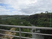
Saharenana River, near
The Saharenana River is located in northern Madagascar and crosses the Route Nationale 6 near . Its sources are situated near Joffreville in the and flows into the Indian Ocean.
References[]
- (in French) Monographie de la Région Diana (on page 13)
Categories:
- Rivers of Diana Region
- Rivers of Madagascar
- Africa river stubs
- Madagascar geography stubs