Saint-Élie
Saint-Élie | |
|---|---|
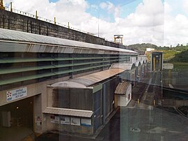
 The Petit-Saut Dam, north-east of the commune | |
 Location of the commune (in red) within French Guiana | |
show Location of Saint-Élie | |
| Coordinates: 4°49′22″N 53°16′35″W / 4.8227°N 53.2764°WCoordinates: 4°49′22″N 53°16′35″W / 4.8227°N 53.2764°W | |
| Country | France |
| Overseas region and department | French Guiana |
| Arrondissement | Cayenne |
| Intercommunality | CC des Savanes |
| Government | |
| • Mayor (2020–2026) | Véronique Jacaria[1] |
| Area 1 | 5,680 km2 (2,190 sq mi) |
| Population (Jan. 2018)[2] | 216 |
| • Density | 0.038/km2 (0.098/sq mi) |
| Time zone | UTC−03:00 |
| INSEE/Postal code | 97358 /97312 |
| 1 French Land Register data, which excludes lakes, ponds, glaciers > 1 km2 (0.386 sq mi or 247 acres) and river estuaries. | |
Saint-Élie is a commune of French Guiana, an overseas region and department of France located in South America. In 1930, Saint-Élie became capital of the Inini territory.[3] From 1953 onward, the commune was called Centre. In 1969, it was renamed to Saint-Élie.[4]
History[]

In 1873, gold was discovered in Saint-Élie. The mines were in the middle of the rain forest with no river connection to the outside world. In 1884 construction began on a Decauville railway line to Gare Tigre near Saint-Nazaire in order to access the Sinnamary River.[5]
The railway line needed frequent repairs, and had over 100 bridges. In 1990, the railway line was abandoned when a road opened.[6] The roads ends near Saint-Nazaire, and a 45 minute ferry to Petit-Saut Dam is needed to reach the outside world.[7]
Gold is still the backbone of the economy. The gold mines are currently being exploited by Newmont Mining Corporation.[8] In 1989, construction started on the Petit-Saut Dam to produce hydroelectric power. The dam was completed in 1994.[9]
Nature[]
In 1996, La Trinité National Nature Reserve was founded. It covers 76,903 hectares and is primary tropical rain forest located in the heart of the Guyana plateau forest.[10]
Villages[]
See also[]
References[]
- ^ "Répertoire national des élus: les maires". data.gouv.fr, Plateforme ouverte des données publiques françaises (in French). 2 December 2020. Retrieved 7 December 2020.
- ^ "Populations légales 2018". INSEE. 28 December 2020.
- ^ "South America 1930: Vargas Revolution". Omni Atlas. Retrieved 4 June 2020.
- ^ "Mairie Saint-Élie". Mairie Saint-Élie (in French). Retrieved 4 June 2020.
- ^ "Industrial Railways in French Guiana, 2014". International Steam. Retrieved 4 June 2020.
- ^ "Quand la Guyane voulait son chemin de fer" (PDF). Alliance Francophone Internationale du Tourisme et des Voyages (in French). Retrieved 4 June 2020.
- ^ "La barrière de la discorde à Saint-Elie". France TV Info (in French). Retrieved 21 March 2021.
- ^ "CME Announces Agreement with Newmont on its Esperance Project and Seeks a Partner for its Saint-Elie Property in French Guiana". Globe News Wire. Retrieved 4 June 2020.
- ^ "Petit Saut Dam". Structurae.net. Retrieved 4 June 2020.
- ^ "Historique Réserve Naturelle La Trinité" (in French). Retrieved 4 June 2020.
External links[]
- Official website (in French)
| Wikimedia Commons has media related to Saint-Élie. |
- Communes of French Guiana
- Saint-Élie

