Saint-Benoît, Ain
This article may be expanded with text translated from the corresponding article in French. (December 2008) Click [show] for important translation instructions.
|
Saint-Benoit | |
|---|---|
Part of Groslée-Saint-Benoît | |
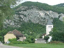 | |
Location of Saint-Benoit  | |
 Saint-Benoit | |
| Coordinates: 45°42′00″N 5°35′00″E / 45.7°N 5.5833°ECoordinates: 45°42′00″N 5°35′00″E / 45.7°N 5.5833°E | |
| Country | France |
| Region | Auvergne-Rhône-Alpes |
| Department | Ain |
| Arrondissement | Belley |
| Canton | Belley |
| Commune | Groslée-Saint-Benoît |
| Area 1 | 21.65 km2 (8.36 sq mi) |
| Population (2019)[1] | 857 |
| • Density | 40/km2 (100/sq mi) |
| Time zone | UTC+01:00 (CET) |
| • Summer (DST) | UTC+02:00 (CEST) |
| Postal code | 01300 |
| Elevation | 201–778 m (659–2,552 ft) (avg. 206 m or 676 ft) |
| 1 French Land Register data, which excludes lakes, ponds, glaciers > 1 km2 (0.386 sq mi or 247 acres) and river estuaries. | |


Saint-Benoit (French pronunciation: [sɛ̃ bənwa] (![]() listen); Arpitan: Sent-Benimo) is a former commune in the Ain department in eastern France. On 1 January 2016, it was merged into the new commune Groslée-Saint-Benoît.[2]
listen); Arpitan: Sent-Benimo) is a former commune in the Ain department in eastern France. On 1 January 2016, it was merged into the new commune Groslée-Saint-Benoît.[2]
Population[]
|
|
See also[]
References[]
- ^ Téléchargement du fichier d'ensemble des populations légales en 2019, INSEE
- ^ Arrêté préfectoral 30 December 2015 (in French)
| Wikimedia Commons has media related to Saint-Benoît, Ain. |
This Ain geographical article is a stub. You can help Wikipedia by . |
Categories:
- Former communes of Ain
- Populated places disestablished in 2016
- Ain geography stubs