Saint-Sulpice-Laurière
Saint-Sulpice-Laurière | |
|---|---|
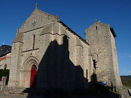 The 13th century church in Saint-Sulpice-Laurière | |
 Coat of arms | |
show Location of Saint-Sulpice-Laurière | |
 Saint-Sulpice-Laurière | |
| Coordinates: 46°03′13″N 1°28′18″E / 46.0536°N 1.4717°ECoordinates: 46°03′13″N 1°28′18″E / 46.0536°N 1.4717°E | |
| Country | France |
| Region | Nouvelle-Aquitaine |
| Department | Haute-Vienne |
| Arrondissement | Limoges |
| Canton | Ambazac |
| Government | |
| • Mayor (2020–2026) | Jean-Michel Peyrot[1] |
| Area 1 | 14.31 km2 (5.53 sq mi) |
| Population (Jan. 2018)[2] | 831 |
| • Density | 58/km2 (150/sq mi) |
| Time zone | UTC+01:00 (CET) |
| • Summer (DST) | UTC+02:00 (CEST) |
| INSEE/Postal code | 87181 /87370 |
| Elevation | 332–623 m (1,089–2,044 ft) |
| 1 French Land Register data, which excludes lakes, ponds, glaciers > 1 km2 (0.386 sq mi or 247 acres) and river estuaries. | |


Saint-Sulpice-Laurière (Occitan: Sent Superis) is a commune in the Haute-Vienne department in the Nouvelle-Aquitaine region in west-central France.
Inhabitants are known as Saint-Sulpiciens.
See also[]
References[]
- ^ "Répertoire national des élus: les maires". data.gouv.fr, Plateforme ouverte des données publiques françaises (in French). 2 December 2020.
- ^ "Populations légales 2018". INSEE. 28 December 2020.
| Wikimedia Commons has media related to Saint-Sulpice-Laurière. |
| show Authority control |
|---|
This Haute-Vienne geographical article is a stub. You can help Wikipedia by . |
Categories:
- Communes of Haute-Vienne
- Haute-Vienne geography stubs