Saint-Sulpice-de-Mareuil
Saint-Sulpice-de-Mareuil | |
|---|---|
Part of Mareuil en Périgord | |
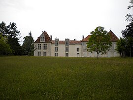 Chateau of La Faye | |
show Location of Saint-Sulpice-de-Mareuil | |
 Saint-Sulpice-de-Mareuil | |
| Coordinates: 45°28′06″N 0°30′27″E / 45.4683°N 0.5075°ECoordinates: 45°28′06″N 0°30′27″E / 45.4683°N 0.5075°E | |
| Country | France |
| Region | Nouvelle-Aquitaine |
| Department | Dordogne |
| Arrondissement | Nontron |
| Canton | Brantôme |
| Commune | Mareuil en Périgord |
| Area 1 | 11.35 km2 (4.38 sq mi) |
| Population (2017)[1] | 112 |
| • Density | 9.9/km2 (26/sq mi) |
| Time zone | UTC+01:00 (CET) |
| • Summer (DST) | UTC+02:00 (CEST) |
| Postal code | 24340 |
| Elevation | 115–225 m (377–738 ft) (avg. 150 m or 490 ft) |
| 1 French Land Register data, which excludes lakes, ponds, glaciers > 1 km2 (0.386 sq mi or 247 acres) and river estuaries. | |


Saint-Sulpice-de-Mareuil (Limousin: Sent Soplesí de Maruelh) is a former commune in the Dordogne department in Nouvelle-Aquitaine in southwestern France. On 1 January 2017, it was merged into the new commune Mareuil en Périgord.[2]
Geography[]
The Lizonne forms the commune's northern border.
Population[]
| Year | Pop. | ±% |
|---|---|---|
| 1962 | 205 | — |
| 1968 | 170 | −17.1% |
| 1975 | 137 | −19.4% |
| 1982 | 128 | −6.6% |
| 1990 | 131 | +2.3% |
| 1999 | 114 | −13.0% |
| 2008 | 121 | +6.1% |
See also[]
References[]
- ^ Téléchargement du fichier d'ensemble des populations légales en 2017, INSEE
- ^ Arrêté préfectoral 26 September 2016 (in French)
| Wikimedia Commons has media related to Saint-Sulpice-de-Mareuil. |
| show Authority control |
|---|
This Dordogne geographical article is a stub. You can help Wikipedia by . |
Categories:
- Former communes of Dordogne
- Dordogne geography stubs