Saint-Vincent-les-Forts
This article may be expanded with text translated from the corresponding article in French. (December 2008) Click [show] for important translation instructions.
|
Saint-Vincent-les-Forts | |
|---|---|
Part of Ubaye-Serre-Ponçon | |
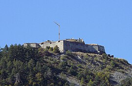 Fort Joubert | |
 Coat of arms | |
Location of Saint-Vincent-les-Forts  | |
 Saint-Vincent-les-Forts | |
| Coordinates: 44°26′46″N 6°22′27″E / 44.4461°N 6.3742°ECoordinates: 44°26′46″N 6°22′27″E / 44.4461°N 6.3742°E | |
| Country | France |
| Region | Provence-Alpes-Côte d'Azur |
| Department | Alpes-de-Haute-Provence |
| Arrondissement | Barcelonnette |
| Canton | Barcelonnette |
| Commune | Ubaye-Serre-Ponçon |
| Area 1 | 22.82 km2 (8.81 sq mi) |
| Population (2019)[1] | 381 |
| • Density | 17/km2 (43/sq mi) |
| Time zone | UTC+01:00 (CET) |
| • Summer (DST) | UTC+02:00 (CEST) |
| Postal code | 04340 |
| Elevation | 770–2,500 m (2,530–8,200 ft) (avg. 1,300 m or 4,300 ft) |
| 1 French Land Register data, which excludes lakes, ponds, glaciers > 1 km2 (0.386 sq mi or 247 acres) and river estuaries. | |


Saint-Vincent-les-Forts (Vivaro-Alpine: Sant Vincenç dei Fòrts) is a former commune in the Alpes-de-Haute-Provence department of southeastern France. On 1 January 2017, it was merged with the commune of La Bréole to form Ubaye-Serre-Ponçon.[2]
Population[]
| Year | Pop. | ±% |
|---|---|---|
| 2006 | 249 | — |
| 2007 | 259 | +4.0% |
| 2008 | 264 | +1.9% |
| 2009 | 282 | +6.8% |
| 2010 | 300 | +6.4% |
| 2011 | 318 | +6.0% |
| 2012 | 321 | +0.9% |
| 2013 | 332 | +3.4% |
| 2014 | 347 | +4.5% |
See also[]
References[]
- ^ Téléchargement du fichier d'ensemble des populations légales en 2019, INSEE
- ^ Arrêté préfectoral 16 December 2016 (in French)
| Wikimedia Commons has media related to Saint-Vincent-les-Forts. |
This Alpes-de-Haute-Provence geographical article is a stub. You can help Wikipedia by . |
Categories:
- Former communes of Alpes-de-Haute-Provence
- Populated places disestablished in 2017
- Alpes-de-Haute-Provence geography stubs