Saint John, Barbados
Saint John | |
|---|---|
 | |
 Map of Barbados showing the Saint John parish | |
| Coordinates: 13°10′N 59°29′W / 13.167°N 59.483°WCoordinates: 13°10′N 59°29′W / 13.167°N 59.483°W | |
| Country | Barbados |
| Largest city | |
| Government | |
| • Type | Parliamentary democracy |
| • Parliamentary seats | 1 |
| Area | |
| • Total | 34 km2 (13 sq mi) |
| Population (2010 census) | |
| • Total | 8,963 |
| • Density | 260/km2 (680/sq mi) |
| ISO 3166 code | BB-05[1] |

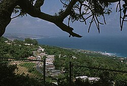
The parish of Saint John (St. John) is a parish of Barbados on the eastern side of the island. It is home to one of its secondary schools, The Lodge School. The parish is the home of many districts such as Ashford and Kendal. It is home to the St. John's Parish Church, which has a scenic view of the Atlantic Ocean from its perch near Hackleton's Cliff, which overlooks the East Coast of the island.[2] In its southeastern corner, the shoreline turns northward, forming the small Conset Bay.[3]
Society Primary is the oldest primary school on the island. It is over 100 years old and was built by the Codrington College.
Geography[]
Populated places[]
The parish contains the following towns, villages, localities, settlements, communities and hamlets:
- Bath
- Cherry Grove
- Kendal
Parishes bordering Saint John[]
- Saint George (west)
- Saint Joseph (north)
- Saint Philip (southeast)
Landmarks[]

Ashford Bird Park is a bird and animal sanctuary of 197 acres (80 ha).
Notable people[]
- Sarah Kirnon, chef[4]
References[]
- ^ iso:code:3166:BB, International Organization for Standardization
- ^ "Historic Churches of Barbados - St.John Parish Church". Retrieved 8 June 2016.
- ^ Plotting location as given by this map onto this image
- ^ "Barbadian chef serving up Caribbean cuisine in California". Loop News. 30 August 2017. Retrieved 3 January 2021.
External links[]
 Media related to Saint John, Barbados at Wikimedia Commons
 Saint John travel guide from Wikivoyage
| Authority control |
|
|---|
This Barbados location article is a stub. You can help Wikipedia by . |
- Saint John, Barbados
- Parishes of Barbados
- Barbados geography stubs