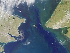
Saint Lawrence Bay, Chukotka
| Saint Lawrence Bay | |
|---|---|
 Saint Lawrence Bay Location of the bay in Chukotka | |
 | |
| Location | Far North |
| Coordinates | 65°40′00″N 171°05′00″W / 65.6667°N 171.0833°WCoordinates: 65°40′00″N 171°05′00″W / 65.6667°N 171.0833°W |
| Native name | Залив Лаврентия (Russian) |
| Ocean/sea sources | Bering Sea |
| Basin countries | Russia |
| Max. length | 45 km (28 mi) |
| Max. width | 8 km (5.0 mi) |
| Settlements | Port Lawrence |
The Saint Lawrence Bay (Russian: Залив Лаврентия; Zaliv Lavrentiya) is a bay in the Bering Sea on the eastern coast of the Chukotka Peninsula, Russian Federation.
Geography[]
This bay is located very close to the Bering Strait, which lies only a few km to the NE.[1]
The bay is open towards the southeast; it is 45 km in length and has an average width of about 8 km. There are two little islands inside the bay where it narrows forming an inlet. On the southern shore of the bay at is the village of Port Lawrence.

History[]
British Captain James Cook landed for a few hours in St. Lawrence Bay and met some of the local Chukchi people in August 1778, but he didn't linger in the bay.[2]
This bay was first surveyed by Russian mariner Count Fyodor Petrovich Litke in 1828.
See also[]
- Lavrentiya
- USS Rodgers (1879)
References[]
- ^ GoogleEarth
- ^ Cook's visit Archived 2008-07-08 at the Wayback Machine
- Bays of Chukotka Autonomous Okrug
- Bays of the Bering Sea
- Chukotka Autonomous Okrug geography stubs
