Salt Creek Falls
| Salt Creek Falls | |
|---|---|
 | |
| Location | Lane County, Oregon |
| Coordinates | 43°36′42″N 122°07′43″W / 43.61179°N 122.12861°WCoordinates: 43°36′42″N 122°07′43″W / 43.61179°N 122.12861°W |
| Type | Cascade, Plunge |
| Elevation | 3,902 ft (1,189 m) |
| Total height | 286 ft (87 m) |
| Number of drops | 1 |
| Average width | 40 ft (12 m) |
| Watercourse | Salt Creek |
| Average flow rate | 6,684 cu ft/s (189.3 m3/s) |

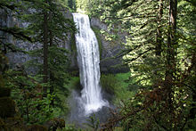
Salt Creek Falls is a cascade and plunge waterfall on Salt Creek, a tributary of the Middle Fork Willamette River, that plunges into a gaping canyon near Willamette Pass in the Willamette National Forest, near Oakridge, Oregon. The waterfall is notable for its main drop of 286 feet (87 m) which makes it the third highest plunge waterfall in Oregon after Multnomah Falls and Watson Falls the second highest, which was re-measured in 2009 and found to be 293 feet rather than an earlier measurement of 272 feet passing Salt Creek Falls.[1][2] The pool at the bottom of the waterfall is 20 metres (66 ft) deep.
Description[]
The Salt Creek Falls drops about 286 feet (87 m),[3] which varies little in height because of the even level of the giant boulders at its crest. The waterfall has a couple of noticeable breaks by protruding rocks that interrupt the horizontal fall of the water. The average annual volume of water approaching the falls is 250 cubic feet per second (7.1 m3/s).[4] At its crest, the waterfall sits at 3,902 ft (1,189 m) above sea level. Since the flow is a direct function of the Salt Creek water volume, it typically peaks when the mountain snow melts in the late spring or early summer. No water diversion facility exists within the falls or anywhere along Salt Creek.
History[]
Salt Creek Falls was formed when glaciers receded during the last ice age, and water from newly formed lakes upstream carved a valley through the forest. The main glacier on the Salt Creek valley seemed to have deepened the canyon at a greater rate than the tributaries, leaving the side valleys towering high above the floor of the river.[5] Lava flows then filled in a portion of this valley, creating narrow canyon walls composed of columnar basalt that are now seen surrounding the falls.[4]
The first reporting of an eyewitness description of Salt Creek Falls is attributed to Frank S. Warner—a resident since birth of Lane County and settler of the Middle Fork Willamette River valley[6]—and a Warm Springs Agency Native American of Molala ancestry named Charles Tufti, who reported the discovery in March 1887.[7] The waterfall gets its name from its parent stream, Salt Creek, a name that comes from a series of springs downstream with high salt content that are often used as mineral licks by wildlife.[4]
Salt Creek Falls and its surrounding amenities are operated by the Hoodoo Recreation Services.[8]
In 2018, The Oregonian newspaper named Salt Creek Falls one of the 50 most beautiful places in the state.[9]
Location and access[]

Salt Creek Falls is situated in the heart of the Cascade Range, in the central portion of the Willamette National Forest, adjacent to the state designed Salt Creek Sno-park and Too Much Bear Lake. It forms on the Salt Creek roughly 4 miles (6.4 km) west of Willamette Pass and a little more than 22 miles (35 km) upstream from its mouth[10][11] at the Middle Fork Willamette River just below Hills Creek Dam.[10][12][13] The falls initially descend over a small number of cascades before the 286-foot (87 m) horsetail drop. In total, the falls descend over 87 metres (285 ft).
Salt Creek Falls is easily accessible by car year-round from Oregon Route 58, also known as the Willamette Highway No. 18, which connects U.S. Route 97 north of Chemult with Interstate 5 south of Eugene. The day use area is about 21 miles (34 km) east of Oakridge, and about 5 miles (8.0 km) west of Willamette Pass.[14] The U.S. Forest Service charges a $5 day use fee, but visitors with a Northwest Forest Pass may park there without the extra fee.[15] There is a viewing platform near the top of the falls, as well as a hiking path down to the bottom.
Hiking trails[]
The Salt Creek Falls Trail has two moderate to difficult paths—a 3.4-mile (5 km) loop hike and a 6-mile (10 km) semi-loop hike.[16] Both start at the interpretive kiosk in the parking lot and gain approximately 400 ft (122 m) in elevation.
Loop hike[]
From the parking lot and to the left of the interpretive kiosk is the beginning of the 3.4-mile (5 km) loop hike upstream of the waterfall on the Salt Creek Falls and Diamond Creek Falls trails.[5] The Salt Creek Falls trail starts with a paved walkway along Salt Creek that leads to a picnic area. Past the picnic area is a bridge over Salt Creek that leads to a faint pathway where the trail divides. Following the right side at the junction leads to about 0.2 miles (0 km) of a quick climb that ends in a wide view of the surrounding canyon. Past this viewpoint, the Diamond Creek Falls Trail continues for about 1.1 miles (2 km) past Too Much Bear Lake and ends in a junction that leads to Diamond Creek Falls, which has access to its base over basalt steps, fissures and boulders.[17]
References[]
- ^ "Salt Creek Falls". Northwest Waterfall Survey. Retrieved 10 September 2015.
- ^ Richard, Terry (January 12, 2014). "Snow isn't essential to enjoy Willamette Pass in Oregon". The Herald. Everett, Washington. Retrieved February 7, 2014.
- ^ Zach Urness (April 13, 2014), Exploring Oregon's second-tallest waterfall at Salt Creek Falls Sno Park. Statesman Journal (Salem, Oregon). Retrieved September 10, 2014.
- ^ a b c "Salt Creek Falls". World Waterfall Database. Retrieved September 10, 2015.
- ^ a b Grubbs, Bruce (1999). Hiking Oregon's Central Cascades. Globe Pequot Press. p. 167. ISBN 1560448733.
- ^ Congressional Edition, Volume 2519. University of California: U.S. Government Printing Office. 1888. p. 89. ISBN 1560448733.
- ^ McArthur, Lewis A.; McArthur, Lewis L. (2003) [1928]. Oregon Geographic Names (7th ed.). Portland, Oregon: Oregon Historical Society Press. pp. 843–844. ISBN 978-0875952772.
- ^ Weber, Robin (September 29, 2002). "Take a hike or go fish". Herald and News. Klamath Falls, Oregon. Retrieved September 10, 2015.
- ^ Hale, Jamie. "Oregon's 50 most beautiful places". OregonLive.com. The Oregonian. Retrieved 27 July 2018.
- ^ a b Oregon (Map) (1993 ed.). 1:500,000. Cartography by Allan Cartography. Medford, Oregon: Raven Maps & Images. 1987. OCLC 41588689.
- ^ United States Geological Survey Topographic Map: Salt Creek Tunnel 2539, Oregon, Quadrangle (Map). Cartography by U.S. Geological Survey. TopoQuest. Retrieved February 17, 2014.
- ^ United States Geological Survey Topographic Map: Jo Ann Lake, Oregon, Quadrangle (Map). Cartography by U.S. Geological Survey. TopoQuest. Retrieved February 17, 2014.
- ^ United States Geological Survey Topographic Map: Lower Marilyn Lake, Oregon, Quadrangle (Map). Cartography by U.S. Geological Survey. TopoQuest. Retrieved February 17, 2014..
- ^ Rakestraw, John (2007). Birding Oregon: 44 Prime Birding Areas with More Than 200 Specific Sites. Globe Pequot Press. p. 92. ISBN 0762739134.
- ^ Travel Oregon
- ^ Sawyer, Adam (1999). Hiking Waterfalls in Oregon: A Guide to the State's Best Waterfall Hikes. Globe Pequot Press. p. 154. ISBN 0762787279.
- ^ "Diamond Creek Falls Trail #3598". U.S. Forest Service. Retrieved September 11, 2015.
External links[]
 Media related to Salt Creek Falls at Wikimedia Commons
- Salt Creek Falls Snow Trail/ Diamond Ck Falls Loop - U.S. Forest Service
- Northwest Waterfall Survey
- Waterfalls of Lane County, Oregon
- Willamette National Forest
- Plunge waterfalls