Salto Abajo
Salto Abajo | |
|---|---|
Barrio | |
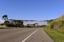 Highway in Salto Abajo | |
 Location of Salto Abajo within the municipality of Utuado shown in red | |
 Salto Abajo Location of Puerto Rico | |
| Coordinates: 18°17′12″N 66°42′37″W / 18.28657°N 66.710307°WCoordinates: 18°17′12″N 66°42′37″W / 18.28657°N 66.710307°W[1] | |
| Commonwealth | |
| Municipality | |
| Area | |
| • Total | 2.66 sq mi (6.9 km2) |
| • Land | 2.63 sq mi (6.8 km2) |
| • Water | 0.03 sq mi (0.08 km2) |
| Elevation | 568 ft (173 m) |
| Population (2010) | |
| • Total | 3,929 |
| • Density | 1,493.9/sq mi (576.8/km2) |
| Source: 2010 Census | |
| Time zone | UTC−4 (AST) |

Salto Abajo is a barrio in the municipality of Utuado, Puerto Rico. Its population in 2010 was 3,929.[3][4][5]
History[]
Puerto Rico was ceded by Spain in the aftermath of the Spanish–American War under the terms of the Treaty of Paris of 1898 and became an unincorporated territory of the United States. In 1899, the United States Department of War conducted a census of Puerto Rico finding that the population of Salto Abajo barrio was 836.[6]
| Historical population | |||
|---|---|---|---|
| Census | Pop. | %± | |
| 1900 | 836 | — | |
| 1980 | 5,127 | — | |
| 1990 | 6,043 | 17.9% | |
| 2000 | 5,724 | −5.3% | |
| 2010 | 3,929 | −31.4% | |
| U.S. Decennial Census[7] 1899 (shown as 1900)[8] 1910-1930[9] 1930-1950[10] 1980-2000[11] 2010[12] | |||
Features[]
The rope bridge in Salto Abajo was destroyed by Hurricane Maria in 2017. Engineering students from the University of New Mexico and University of Texas at El Paso began its reconstruction but never completed the work.[13]
Gallery[]
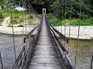
Puente La Hamaca in Salto Abajo, 2010

See also[]
References[]
- ^ a b "US Gazetteer 2019". US Census. US Government.
- ^ U.S. Geological Survey Geographic Names Information System: Salto Abajo barrio
- ^ Picó, Rafael; Buitrago de Santiago, Zayda; Berrios, Hector H. Nueva geografía de Puerto Rico: física, económica, y social, por Rafael Picó. Con la colaboración de Zayda Buitrago de Santiago y Héctor H. Berrios. San Juan Editorial Universitaria, Universidad de Puerto Rico,1969.
- ^ Gwillim Law (20 May 2015). Administrative Subdivisions of Countries: A Comprehensive World Reference, 1900 through 1998. McFarland. p. 300. ISBN 978-1-4766-0447-3. Retrieved 25 December 2018.
- ^ Puerto Rico:2010:population and housing unit counts.pdf (PDF). U.S. Dept. of Commerce, Economics and Statistics Administration, U.S. Census Bureau. 2010.
- ^ Joseph Prentiss Sanger; Henry Gannett; Walter Francis Willcox (1900). Informe sobre el censo de Puerto Rico, 1899, United States. War Dept. Porto Rico Census Office (in Spanish). Imprenta del gobierno. p. 161.
- ^ "U.S. Decennial Census". United States Census Bureau. Archived from the original on February 13, 2020. Retrieved September 21, 2017.
- ^ "Report of the Census of Porto Rico 1899". War Department Office Director Census of Porto Rico. Archived from the original on July 16, 2017. Retrieved September 21, 2017.
- ^ "Table 3-Population of Municipalities: 1930 1920 and 1910" (PDF). United States Census Bureau. Archived (PDF) from the original on August 17, 2017. Retrieved September 21, 2017.
- ^ "Table 4-Area and Population of Municipalities Urban and Rural: 1930 to 1950" (PDF). United States Census Bureau. Archived (PDF) from the original on August 30, 2015. Retrieved September 21, 2014.
- ^ "Table 2 Population and Housing Units: 1960 to 2000" (PDF). United States Census Bureau. Archived (PDF) from the original on July 24, 2017. Retrieved September 21, 2017.
- ^ Puerto Rico:2010:population and housing unit counts.pdf (PDF). U.S. Dept. of Commerce Economics and Statistics Administration U.S. Census Bureau. 2010. Archived (PDF) from the original on 2017-02-20. Retrieved 2019-08-02.
- ^ Arroyo Guzmán, Paola (2018-09-20). "Utuado busca la forma de sobrevivir". El Vocero de Puerto Rico (in Spanish). Retrieved 2021-04-11.
This Utuado, Puerto Rico location article is a stub. You can help Wikipedia by . |
- Barrios of Utuado, Puerto Rico
- Puerto Rico Senatorial district V geography stubs