Samoklęski Duże
Samoklęski Duże | |
|---|---|
Village | |
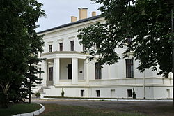 Palace in Samoklęski Duże | |
 Samoklęski Duże | |
| Coordinates: 53°5′N 17°42′E / 53.083°N 17.700°ECoordinates: 53°5′N 17°42′E / 53.083°N 17.700°E | |
| Country | |
| Voivodeship | Kuyavian-Pomeranian |
| County | Nakło |
| Gmina | Szubin |
| First mentioned | 1337 |
| Population | 493 |
| Time zone | UTC+1 (CET) |
| • Summer (DST) | UTC+2 (CEST) |
| Vehicle registration | CNA |


Samoklęski Duże [samɔˈklɛ̃ski ˈduʐɛ] is a village in the administrative district of Gmina Szubin, within Nakło County, Kuyavian-Pomeranian Voivodeship, in north-central Poland.[1] It lies approximately 9 kilometres (6 mi) north-west of Szubin, 10 km (6 mi) south-east of Nakło nad Notecią, and 21 km (13 mi) west of Bydgoszcz.
The village has a population of 493.
History[]

The oldest known mention of the village comes from 1337, when it was part of the Piast-ruled Kingdom of Poland. The Saint Bartholomew Catholic parish was established in the 14th century. Samoklęski Duże was a private village of Polish nobility, administratively located in the Kcynia County in the Kalisz Voivodeship in the Greater Poland Province of the Polish Crown.[2]
References[]
- ^ "Central Statistical Office (GUS) – TERYT (National Register of Territorial Land Apportionment Journal)" (in Polish). 2008-06-01.
- ^ Atlas historyczny Polski. Wielkopolska w drugiej połowie XVI wieku. Część I. Mapy, plany (in Polish). Warszawa: Instytut Historii Polskiej Akademii Nauk. 2017. p. 1b.

This Nakło County location article is a stub. You can help Wikipedia by . |
- Villages in Nakło County
- Nakło County geography stubs