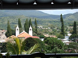
San Marcos de Colón
This article needs additional citations for verification. (July 2014) |
San Marcos de Colón
(Mandaime) | |
|---|---|
Municipality | |
 | |
 San Marcos de Colón | |
| Coordinates: 13°16′0″N 86°48′0″W / 13.26667°N 86.80000°WCoordinates: 13°16′0″N 86°48′0″W / 13.26667°N 86.80000°W | |
| Country | |
| Department | Choluteca |
| Municipio (County) | San Marcos de Colón |
| Foundation | 1824 |
| Government | |
| • Mayor | Douglas Ordóñez (Since January 25th 2010) |
| • Vice-mayor | José Jorge Espinal |
| Area | |
| • Municipality | 578 km2 (223 sq mi) |
| Elevation | 960 m (3,150 ft) |
| Population (2020 projection)[1] | |
| • Municipality | 30,449 |
| • Density | 36/km2 (90/sq mi) |
| • Urban | 14,773 |
| Time zone | |

San Marcos de Colón is a town, with a population of 12,870 (2020 calculation),[2] and a municipality in the Honduran department of Choluteca, located on the border with Nicaragua.
The town is located on the Pan-American Highway near the Nicaraguan border town of Somoto, and 192 km away from the capital Tegucigalpa.
History[]
The town received city status in 1927, though its origins date back to 1795.[3]
Climate[]
The climate has traditionally been described as tropical. However, due to widespread agricultural deforestation and a higher altitude (3500 to 5000 feet above sea level); the climate can be more aptly described in many cases as temperate. It can be dusty in the dry season (January through March).
Sports[]
The local football team, Atlético Pinares, played in the second tier of Honduran football until it sold its franchise to Comayagua F.C. in 2012.
References[]
- ^ Citypopulation.de Population of departments and municipalities in Honduras
- ^ Citypopulation.de Population of cities in Honduras
- ^ Remodelan edificio municipal de San Marcos de Colón - El Heraldo (in Spanish)
| Wikimedia Commons has media related to San Marcos de Colón. |
Capital: Choluteca | ||
| Municipalities |  | |
This Honduras location article is a stub. You can help Wikipedia by . |
- Municipalities of the Choluteca Department
- Honduras geography stubs