San Pedro River (Guatemala)
| San Pedro River/Río San Pedro | |
|---|---|
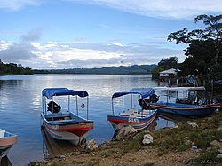 San Pedro River, at El Naranjo, Petén | |
| Location | |
| Countries | Guatemala and Mexico |
| Physical characteristics | |
| Source | |
| • location | Guatemala (El Petén) |
| • coordinates | 17°08′05″N 89°54′10″W / 17.134803°N 89.902668°W |
| • elevation | 200 m (660 ft) |
| Mouth | |
• location | Tributary of the Usumacinta river |
| Length | 186 km (116 mi) (in Guatemala) |
| Discharge | |
| • average | 52.9 m3/s (1,870 cu ft/s) (at San Pedro Mactún) |

The Río San Pedro is a river of Guatemala and Mexico. Its sources are located in the Guatemalan department of El Petén. at 17°08′05″N 89°54′10″W / 17.134803°N 89.902668°W. The river flows westwards until it reaches the Mexican border and crosses into the state of Tabasco at 17°16′47″N 90°59′16″W / 17.279636°N 90.987697°WCoordinates: 17°16′47″N 90°59′16″W / 17.279636°N 90.987697°W. From there it continues northwest and joins the Usumacinta River. The Guatemalan part of the San Pedro river basin covers an area of 14,335 square kilometres (5,535 sq mi).[1]
References[]
- ^ INSIVUMEH. "Principales ríos de Guatemala". Retrieved 14 July 2008.
External links[]
This article related to a river in Mexico is a stub. You can help Wikipedia by . |
Categories:
- Rivers of Guatemala
- Geography of Mesoamerica
- International rivers of North America
- Rivers of Tabasco
- Usumacinta River
- Guatemala river stubs
- Mexico river stubs