San Pedro de Tiquina Municipality
San Pedro de Tiquina | |
|---|---|
Municipality | |
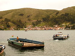 Strait of Tiquina, Lake Titicaca, Bolivia | |
 San Pedro de Tiquina Location of the Arani Municipality within Bolivia | |
| Coordinates: 16°14′0″S 68°52′0″W / 16.23333°S 68.86667°WCoordinates: 16°14′0″S 68°52′0″W / 16.23333°S 68.86667°W | |
| Country | |
| Department | La Paz Department |
| Province | Manco Kapac Province |
| Seat | San Pedro de Tiquina |
| Government | |
| • Mayor | Gregorio Argani Quispe |
| • President | Freddy Poma Peñaranda |
| Area | |
| • Total | 20 sq mi (60 km2) |
| Elevation | 12,630 ft (3,850 m) |
| Population (2001) | |
| • Total | 6,093 |
| • Ethnicities | Aymara |
| Time zone | UTC-4 (BOT) |

San Pedro de Tiquina Municipality is the second municipal section of the Manco Kapac Province in the La Paz Department in Bolivia. Its seat is San Pedro de Tiquina.
Subdivision[]
The municipality is divided into five cantons.
| Canton | Inhabitants (2001)[1] | Seat |
|---|---|---|
| 1,282 | ||
| 1,474 | San Pablo de Tiquina | |
| 839 | San Pedro de Tiquina | |
| 516 | Santiago de Ojje | |
| 1,982 |
The people[]
The people are predominantly indigenous citizens of Aymaran descent.
| Ethnic group | % |
|---|---|
| Quechua | 1.1 |
| Aymara | 91.6 |
| Guaraní, Chiquitos, Moxos | 0.2 |
| Not indigenous | 6.9 |
| Other indigenous groups | 0.2 |
Ref.: obd.descentralizacion.gov.bo
Languages[]
The languages spoken in the San Pedro de Tiquina Municipality are mainly Aymara and Spanish.
| Language | Inhabitants |
|---|---|
| Quechua | 114 |
| Aymara | 4,884 |
| Guaraní | 3 |
| Another native | 8 |
| Spanish | 4,440 |
| Foreign | 41 |
| Only native | 1,409 |
| Native and Spanish | 3,518 |
| Only Spanish | 924 |
See also[]
References[]
External links[]
| Wikimedia Commons has media related to San Pedro de Tiquina Municipality. |

This La Paz Department geography article is a stub. You can help Wikipedia by . |
Categories:
- Municipalities of La Paz Department (Bolivia)
- La Paz Department (Bolivia) geography stubs