San Pedro del Pinatar
San Pedro del Pinatar | |
|---|---|
 Town's view from the salt ponds | |
 Flag  Coat of arms | |
 Location in Murcia | |
 San Pedro del Pinatar Location in Murcia | |
| Coordinates: 37°49′N 0°45′W / 37.817°N 0.750°WCoordinates: 37°49′N 0°45′W / 37.817°N 0.750°W | |
| Country | |
| Autonomous community | |
| Province | Murcia |
| Comarca | Mar Menor |
| Judicial district | San Javier |
| Government | |
| • Alcalde | Visitación Martínez Martínez (2011) (PP) |
| Area | |
| • Total | 22.32 km2 (8.62 sq mi) |
| Elevation | 13 m (43 ft) |
| Population (2018)[1] | |
| • Total | 25,167 |
| • Density | 1,100/km2 (2,900/sq mi) |
| Demonym(s) | Pinatarense |
| Time zone | UTC+1 (CET) |
| • Summer (DST) | UTC+2 (CEST) |
| Postal code | 30740 |
| Official language(s) | Español |
| Website | Official website |


This article may require copy editing for wording/grammar likely translated from Spanish. (August 2021) |


San Pedro del Pinatar is a small town and municipality in the autonomous community and province of Murcia, southeastern Spain. The municipality is situated at the northern end of Murcia's Mediterranean coastline, the Costa Cálida, and borders with the province of Alicante. It has an area of almost 22 km², and a population (2018) of 25,167.[2]
Geography[]
San Pedro del Pinatar (Saint Peter of the Pinewoods) is about 49 km from the provincial capital, Murcia. The municipality is situated between the Mediterranean Sea coast and the Mar Menor ('Little Sea'), a coastal saltwater lagoon which is the largest in Europe. The Mar Menor coast belongs to other three municipalities: San Javier, Los Alcázares and Cartagena. The latter is not by the Mar Menor itself, but in the Mediterranean. San Pedro del Pinatar occupies a small peninsula with 14 km of coastline between the two seas. The terrain is a mostly low-lying littoral depression, with an average elevation of only 13 m above mean sea level.
History[]
In regards to underwater archaeology related to Spain, the sea adjoining San Pedro de Pinatar is one of the most outstanding spots. There are remains such as amphora slices, wreckages, and pond walls for salting production. These elements are traces of the presence of civilizations such as Phoenicians, Hellenics, Punics and Ancient Romans. Those people carried in their vessels silver ingots, gold ingots and amphorae. Iberian people also occupied territory belonging to the current municipality. Iberian also occupied this area and traded with the Phoenicians who brought spices, fabrics, ceramic and splicers of glass.
In the year 218 BC a war between the Romans and the Punics started and its name is Second Punic War. In the year 209 the Romans conquered Cartago Nova (currently Cartagena). As a consequence a large part of the Iberian Peninsula became dominated by the Romans and San Pedro del Pinatar was included.
San Pedro became an industrial territory whose salt mines were used by the Romans with salting purposes. They utilised this salt for producing an Ancient Roman sauce named garum. This salting activity is proved with the discovery of Roman villas and column shafts.[3]
In the year 711 Muslim civilizations started conquering the Iberian Peninsula. A few years later they dominated a great part of it, including the current San Pedro del Pinatar. During the period in which they occupied the territory, they built fishing structures for a specific type of fishing; in Spanish the structures are known as encañizadas.[4]
In the year 1243, the king Muhammad Ibn Hud offered vassalage to Castile. In April of that year, the Treaty of Alcaraz, in which the sovereignty of Castile was recognised, was signed. As a result, all the former Taifa of Murcia became under rule of Castile and this current municipality, as a part of it too. The jurisdiction of the concejo (an administrative division of that era approximately equivalent to the municipality) occupies this territory.[4]
San Pedro del Pinatar was part of the Crown of Castile but it was adjoining the Crown of Aragon. Setting a border which crossed Campo de Cartagena (a region that has the Spanish category of comarca) and ended in San Pedro was decided in the year 1305.[4]
A book was written in the year 1340 called El Libro de montería de Alfonso XI; the aspect of the current municipality in the Late Middle Ages is described in that work. It was written that the territory was a dense forest mass where wild boar were hunted.[4]
In the twilight of the Middle Ages Muslims of Granada entered the territories of Murcia and Cartagena and they reached El Pinatar. They battled against Christian soldieries and the Muslims had to retreat and move to the valley of Guadalentín (a river which is located in the south-west of the Region of Murcia).
San Pedro del Pinatar was the scene of an increase in population in the late years of the Middle Ages owing to the arrival of families.[4]
The localities of the municipality were set up in the beginning of the early modern period. The salty mines were utilised by the lessees who reached rights on the mines at a similar level to the Crown. This institution awarded shares to these lessees in order to regain the power on the salty lands. The untroublesome access to the coastal salty lagoon Mar Menor led to Berber pirates to disembark easily, destroy the region and take the loot. Typical Spanish coastal watchtowers were built along the coast. The king Philip II of Spain got a letter written, in which an intention for setting up a tower was announced, on 6 June 1592 in order to set up a defence system for the region. This tower was built in 1602 and it was armed with artillery and manned until the 18th century.[5]
The 17th century is a period in which many little churches and little shrines appeared in El Pinatar owing to Franciscan missions. The inhabitants of El Pinatar hamlet consisted of mainly fishermen, farmers, mule drivers.
From 1700 to 1713 a war whose name is War of the Spanish Succession occurred. People in Reino of Murcia (an administrative division belonging to the Crown of Castile whose status was similar to an ordinary kingdom) took sides with Philip V of Spain. The supporters of the Archduke Charles VI, Holy Roman Emperor attacked Cartagena in the year 1706, its port and the region related to Mar Menor.[5]
During the last years in the Early Modern period the tranquility and the prosperity were present in the territory due to the decrease in privateer attacks. As a consequence, there was an economic rise and an increase in population in that era. The municipal registers, in regards to population, stayed that the number of inhabitants doubled in the last years of the 18th century from 1771 to 1798.[5]
In 1829 there was an earthquake in San Pedro del Pinatar. In the 19th century there was a cholera epidemic in no little part of Region of Murcia, but San Pedro was not affected by it. This fact led people from Murcia and Cartagena to obtain dwellings in the territory.[6]
During the Trienio Liberal (1820–1823) and taking advantage of the just-arrived liberalism, the process for getting their own local government was carried out and turn out in success but after this period, when the political system corresponding to the previous politic regime to the French Revolution was instituted, the local government was eliminated and the territory was part of the municipality of Murcia again. After the death of Ferdinand VII, the political regime corresponding to the previous eras to the French Revolution was removed and the liberalism was reestablished. In the context of this situation, San Pedro achieved its own local government again on 16 September 1836.[6]
Coastal Customs were set in San Pedro del Pinatar in the year 1857. In the year 1869, a law which eliminated the monopoly of the salty mines was presented.[6]
In the first years of the 20th century some families related to the nobility spent the summer in San Pedro del Pinatar. The people from Huerta de Murcia (a region in Region of Murcia that has the Spanish category of comarca) summered in that town.
The inhabitants of the municipality did economic activities such as fishing and agriculture. The activity related to land was hindered in that era because of lack of lands and the drought. There were attempts to attenuate these obstacles that consisted of lifting the water by waterwheels and water mills.[6]
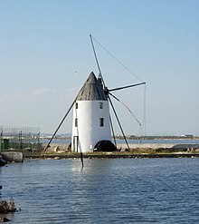
The activities on salty mines were among the main economic activities and an inexhaustible work source. Some mills related to salty activities were built in order to decant the water from Mar Menor to the salty mines by using wind energy. Nowadays a few of them are still preserved.[6]
In the 1960s a touristic rise began in the municipality and that led to an economic rise and the appearance of many employments related to construction and service sector. There was an increase in population resulting from the improve of standard of living - The number of inhabitants double - In the year 1971 there were 6,637 people living in San Pedro and 20 years after the population of the town consisted of 13,000 inhabitants.[6]
Demography and administrative divisions[]
The 24,093 inhabitants of San Pedro del Pinatar are distributed in the following districts: San Pedro del Pinatar, whose number of inhabitants is 10,491; Lo Pagán, whose population is 2,907; Los Peñascos, where 1594 people live; Los Sáez, whose number of inhabitants is 1499; Las Esperanzas, where 1454 people live; Los Antolinos, which has 1238 residents; Loma de Abajo, where 786 people live; Los Tárragas, whose population consists in 750; Los Imbernones, where 329 people live; El Mojón, which has a population of 236; Los Veras, where there are 211 residents; Loma de Arriba, Las Beatas, where 192 people live; whose population consists in 104; Los Gómez, whose number of inhabitants is 79; Las Pachecas, whose population consists of 37 and Las Salinas where 5 people live.[7][8]
Economy and industries[]
Fishing and related processing industries have been a mainstay of the local municipal economy, with tourism and service–related industries playing an ever-increasing role.
Salt ponds have been worked in the area since the time of the Roman Empire.
A small port in the Mediterranean Sea exists, with activity based on the fishing and the transport of the salt; as well as a leisure port with a large number of berths. There is another marina in the Mar Menor next to the fish market and the fishermen's wharf .
Entertainment[]
San Pedro del Pinatar continues to be a very popular Spanish holiday destination and the population increases during the summer months as people from Madrid (and other Spaniards) with second homes descend on the area. Much free entertainment is provided by the council.
Celebrations[]
- Processions and parades at Easter
- At the end of June, San Pedro Apostle.
- On 16 July, "romería" of the Virgin of the Carmen.
Monuments and places of interest[]
- Ethnographic Archaeological museum (Calle Dr. Mirón de Castro: It contains paleontological fossils, objects, etc. It has an exclusive room for submarine archaeology and another one for the ethnographic type dedicated to the last centuries (from the 18th century).
- Museum of the Sea (Calle Ingeniero Lorenzo Morales, 2.): marine and marine article collections.
- Conservation and research center of the Humedales "Las Salinas" (Avda. de las salinas): it offers interesting exhibitions on the natural park and the work in the salt mines.
- "Casa del reloj" or Villa of San Sebastian (Avda. Artero Guirao): an example of modernist architecture. The Spanish president, Emilio Castelar y Ripoll, died here in 1899. Since the end of the 20th century it has been reconstructed and turned into a restaurant.
- Church of San Pedro Apostle (Plaza de la Constitucion): it is a temple that became a Franciscan hermitage in the 17th century.
- Palace of counts Villar de Felices or Casa of the Russian (C/ Victor Pradera s/n): building in neo-mudéjar style constructed in the 19th century by order of Baron de Benifalló.
- Fish Market in Lo Pagán (Explanada of Lo Pagán): a traditional fish auction can be seen here.
- The "Salinas y Arenales" natural park.
Beaches[]
In the Mar Menor:
- Villananitos
- La Puntica
- La Mota
In the Mediterranean Sea:
- Beach El Mojón
- Beach of La Torre Derribada Playa
- Beach of Las Salinas
- Beach Punta de Algas
- Beach of La Barraca Quemada
Others links[]
- (in Spanish) Salinas y Arenales de San Pedro del Pinatar
References[]
- ^ Municipal Register of Spain 2018. National Statistics Institute.
- ^ "INEbase / Demography and population /Municipal Register. Population by municipality /Nomenclature: Continuous Register Population by Population Unit / Results". ine.es. Retrieved 2019-01-28.
- ^ "Historia de San Pedro del Pinatar- Antigüedad - Región de Murcia Digital" (in Spanish). Retrieved 2019-01-18.
- ^ Jump up to: a b c d e "Historia de San Pedro del Pinatar- Edad Media - Región de Murcia Digital" (in Spanish). Retrieved 2019-01-18.
- ^ Jump up to: a b c "Historia de San Pedro del Pinatar- Edad Moderna - Región de Murcia Digital" (in Spanish). Retrieved 2019-01-18.
- ^ Jump up to: a b c d e f "Historia de San Pedro del Pinatar- Edad Contemporánea - Región de Murcia Digital" (in Spanish). Retrieved 2019-01-18.
- ^ "Pedanías de San Pedro del Pinatar - Región de Murcia Digital" (in Spanish). Retrieved 2019-01-20.
- ^ "INEbase / Demography and population /Municipal Register. Population by municipality /Nomenclature: Continuous Register Population by Population Unit / Results". www.ine.es. Retrieved 2019-01-20.
External links[]
| Wikimedia Commons has media related to San Pedro del Pinatar. |
- (in Spanish) Local Government website
- San Pedro del Pinatar
- Lo Pagan coastal neighborhood of San Pedro
| show Municipalities in the Region of Murcia |
|---|
| show Authority control |
|---|
- Municipalities in the Region of Murcia