Sandyford, Newcastle upon Tyne
This article needs additional citations for verification. (February 2022) |
| Sandyford | |
|---|---|
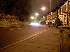 Sandyford Road, the north-west boundary of Sandyford (on the right) | |
| OS grid reference | NZ257658 |
| Metropolitan borough | |
| Metropolitan county | |
| Region | |
| Country | England |
| Sovereign state | United Kingdom |
| Post town | NEWCASTLE UPON TYNE |
| Postcode district | NE2; NE7 |
| Dialling code | 0191 |
| Police | Northumbria |
| Fire | Tyne and Wear |
| Ambulance | North East |
| UK Parliament | |
| Councillors | |

Sandyford is a small district in central Newcastle upon Tyne. It represents the north-eastern border of central Newcastle, with the suburbs of Jesmond to the north and Heaton to the east.
Population[]
Similarly to neighbouring Jesmond, Sandyford is home to a large number of students because of its close proximity to Newcastle University and Northumbria University.
Architecture[]
Sandyford's housing stock is mostly red brick Victorian terraced housing, and many of these are Tyneside flats. Towards the south-east, the residential streets run steeply downwards to Jesmond Dene.
In the south of Sandyford, there are some light industrial business buildings, including offices and small warehouses.
Transport[]
Sandyford is serviced by the Tyne and Wear Metro, with the nearest station being Jesmond Metro station.[1]
References[]
- ^ Walton Robinson. "Houses & Apartments in Sandyford". Retrieved 23 May 2012.
This Tyne and Wear location article is a stub. You can help Wikipedia by . |
- Districts of Newcastle upon Tyne
- Tyne and Wear geography stubs