Sankhaburi district
(Redirected from )
Sankhaburi
สรรคบุรี | |
|---|---|
 Wat Phra Kaeo in tambon Phraek Si Racha | |
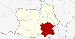 District location in Chai Nat province | |
| Coordinates: 15°2′50″N 100°9′42″E / 15.04722°N 100.16167°ECoordinates: 15°2′50″N 100°9′42″E / 15.04722°N 100.16167°E | |
| Country | Thailand |
| Province | Chai Nat |
| Seat | Phraek Si Racha |
| Area | |
| • Total | 354.8 km2 (137.0 sq mi) |
| Population (2008) | |
| • Total | 67,333 |
| • Density | 192.8/km2 (499/sq mi) |
| Time zone | UTC+7 (ICT) |
| Postal code | 17140 |
| Geocode | 1805 |

Sankhaburi (Thai: สรรคบุรี) is a district (amphoe) in the southern part of Chai Nat province, central Thailand.
Geography[]
Neighbouring districts are (from the west clockwise) Hankha, Mueang Chai Nat, and Sapphaya of Chai Nat Province; In Buri and Bang Rachan of Sing Buri province; and Doem Bang Nang Buat of Suphan Buri province.
Administration[]
The district is divided into eight sub-districts (tambons), which are further subdivided into 92 villages (mubans). Phraek Si Racha is a township (thesaban tambon) which covers parts of tambon Phraek Si Racha. There are a further eight tambon administrative organizations (TAO).
| No. | Name | Thai | Villages | Pop.[1] |
|---|---|---|---|---|
| 1. | Phraek Si Racha | แพรกศรีราชา | 16 | 16,467 |
| 2. | Thiang Thae | เที่ยงแท้ | 10 | 6,283 |
| 3. | Huai Krot | ห้วยกรด | 9 | 9,012 |
| 4. | Pho Ngam | โพงาม | 13 | 7,692 |
| 5. | Bang Khut | บางขุด | 12 | 7,316 |
| 6. | Dong Khon | ดงคอน | 16 | 12,121 |
| 7. | Don Kam | ดอนกำ | 8 | 2,926 |
| 8. | Huai Krot Phatthana | ห้วยกรดพัฒนา | 8 | 5,516 |
References[]
- ^ "Population statistics 2008". Department of Provincial Administration. Archived from the original on 2012-08-19.
External links[]
- amphoe.com (Thai)
This Chainat Province location article is a stub. You can help Wikipedia by . |
Categories:
- Districts of Chai Nat province
- Central Thailand geography stubs