Sankt Leonhard im Pitztal
St. Leonhard im Pitztal | |
|---|---|
 | |
 Coat of arms | |
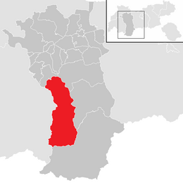 Location in the district | |
 St. Leonhard im Pitztal Location within Austria | |
| Coordinates: 47°04′00″N 10°50′00″E / 47.06667°N 10.83333°ECoordinates: 47°04′00″N 10°50′00″E / 47.06667°N 10.83333°E | |
| Country | Austria |
| State | Tyrol |
| District | Imst |
| Government | |
| • Mayor | Rupert Hosp |
| Area | |
| • Total | 223.53 km2 (86.31 sq mi) |
| Elevation | 1,366 m (4,482 ft) |
| Population (2018-01-01)[2] | |
| • Total | 1,382 |
| • Density | 6.2/km2 (16/sq mi) |
| Time zone | UTC+1 (CET) |
| • Summer (DST) | UTC+2 (CEST) |
| Postal code | 6481 |
| Area code | 05413 |
| Vehicle registration | IM |
| Website | www.st-leonhard.tirol.gv.at |

Sankt Leonhard im Pitztal is a municipality in the Imst district, located 20 kilometres (12 mi) south of Imst on the upper course of the Pitze River in western Austria. The village covers a large area and has a length of around 25 kilometres (16 mi). It is one of the biggest communities of Tyrol by area.
The climate is severe because of mountain flanks. The area was founded around 1300, and its main source of income is tourism.
Population[]
| Year | Pop. | ±% |
|---|---|---|
| 1869 | 1,147 | — |
| 1880 | 1,057 | −7.8% |
| 1890 | 1,039 | −1.7% |
| 1900 | 986 | −5.1% |
| 1910 | 1,032 | +4.7% |
| 1923 | 932 | −9.7% |
| 1934 | 983 | +5.5% |
| 1939 | 989 | +0.6% |
| 1951 | 1,042 | +5.4% |
| 1961 | 1,150 | +10.4% |
| 1971 | 1,224 | +6.4% |
| 1981 | 1,299 | +6.1% |
| 1991 | 1,404 | +8.1% |
| 2001 | 1,472 | +4.8% |
| 2011 | 1,463 | −0.6% |
References[]
- ^ "Dauersiedlungsraum der Gemeinden Politischen Bezirke und Bundesländer - Gebietsstand 1.1.2018". Statistics Austria. Retrieved 10 March 2019.
- ^ "Einwohnerzahl 1.1.2018 nach Gemeinden mit Status, Gebietsstand 1.1.2018". Statistics Austria. Retrieved 9 March 2019.
External links[]
This section is empty. You can help by . (March 2013) |
External links[]
| Wikimedia Commons has media related to St. Leonhard im Pitztal. |
- www.st-leonhard.tirol.gv.at - city website
| Authority control |
|---|
This Tyrol location article is a stub. You can help Wikipedia by . |
Categories:
- Cities and towns in Imst District
- Tyrol geography stubs