Santa María Magdalena de Pazzis Cemetery
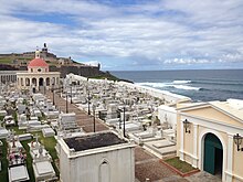
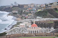
 View of western part of cemetery overlooking the Atlantic Ocean | |
| Details | |
|---|---|
| Established | 1863 |
| Location | |
| Country | United States |
| Type | Public |
| No. of graves | est. 1,000 |
| Find a Grave | Santa Maria Magdalena de Pazzis Cemetery |
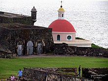
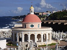
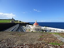
The Santa María Magdalena de Pazzis Cemetery is a colonial-era cemetery located in Old San Juan, Puerto Rico. It is the final resting place of many of Puerto Rico's most prominent natives and residents. Construction began in 1863 under the auspices of Ignacio Mascaro. The cemetery is located outside the walls of Fort San Felipe del Morro fortress, one of the island's most famous landmarks. The average height of the wall is 40 feet and the width ranges from 15 to 20 feet.[1] It was named in honor of Saint Maria Magdalena de Pazzi.

According to Rafael Rodríguez, Chaplain and director of pastoral services at the Universidad del Sagrado Corazón located in the Santurce district of the capital, the location of the cemetery is central to the Puerto Rican belief in the separation of death and life. The colonial Spanish government at the time construction of the cemetery commenced, viewed death with fear because it was a mystery. Therefore, they decided to build the cemetery to overlook the Atlantic Ocean to symbolize the spirit's journey to cross over to the afterlife.[2]
Notable interments[]

- Pedro Albizu Campos, nationalist leader and politician
- Aurora de Albornoz, scholar, poet
- José Julián Acosta, abolitionist, journalist
- Ricardo Alegría, father of modern Puerto Rican archaeology
- Miguel Ángel Álvarez, journalist, comedian and actor
- Jose Celso Barbosa, founder of the Puerto Rican statehood movement
- Antonio R. Barceló, lawyer, businessman and politician
- Félix Benítez Rexach, architect and engineer
- Salvador Brau, journalist, poet and historian
- Norma Candal, actress
- Gilberto Concepción de Gracia, politician, founder of the Puerto Rican Independence Party
- Rafael Cordero, known as "The Father of Public Education in Puerto Rico".
- Tony Croatto, Italian-Puerto Rican folk singer, composer and television presenter
- Tite Curet Alonso, composer
- Conchita Dapena, former First Lady of Puerto Rico
- José de Diego, poet, lawyer and liberal politician
- Manuel Fernandez Juncos, Spanish writer, Poet, Journalist, Writer of Puerto Rican national anthem
- José Ferrer, Academy Award-winning actor and director
- Miguel Ferrer, actor; José Ferrer's son
- Pedro Flores, composer
- José Gautier Benítez, poet
- Rafael Hernández, composer and musician
- Victoria Hernández, music entrepreneur and musician
- Santiago Iglesias, former Resident Commissioner of Puerto Rico
- Tito Lara, composer and musician
- Lolita Lebrón, nationalist leader
- Muna Lee, American writer and first wife of Luis Muñoz Marín
- Gilberto Monroig, singer
- Samuel R. Quiñones, politician
- Evaristo Ribera Chevremont, poet
- Ramón Rivero (Diplo), actor and comedian
- Ángel Rivero Méndez, soldier, writer, journalist and a businessman who is credited with inventing the "Kola Champagne"
- Pedro Salinas, Spanish poet
- Miguel Ángel Suárez, actor
- Salvador Tió Montes de Oca, writer, poet, journalist
- Rafael Tufiño, painter and graphic artist
See also[]
| Wikimedia Commons has media related to Santa María Magdalena de Pazzis Cemetery. |
References[]
- ^ Puerto Rico’s Hidden Treasure Archived 2012-07-22 at archive.today from the Gaylord College of Journalism and Mass Communication
- ^ Puerto Rico’s Hidden Treasure Archived 2012-07-22 at archive.today from the Gaylord College of Journalism and Mass Communication
External links[]
- Santa María Magdalena de Pazzis Cemetery on Find A Grave
- Photographic slideshow on Flickr
| hide Authority control | |
|---|---|
| General | |
| National libraries | |
Coordinates: 18°28′11″N 66°07′13″W / 18.46972°N 66.12028°W

- Cemeteries in Puerto Rico
- Geography of San Juan, Puerto Rico
- 1863 establishments in Puerto Rico
- Buildings and structures in San Juan, Puerto Rico
- Tourist attractions in San Juan, Puerto Rico