Santiam Lake
| Santiam Lake | |
|---|---|
 The lake as seen from Three Fingered Jack | |
 Santiam Lake | |
| Location | Oregon Cascades NW of Santiam Pass, Linn County, Oregon, United States |
| Coordinates | 44°28′41″N 121°53′06″W / 44.47792°N 121.88496°WCoordinates: 44°28′41″N 121°53′06″W / 44.47792°N 121.88496°W |
| Type | Paternoster lake |
| Primary outflows | North Santiam River |
| Basin countries | United States |
| Max. length | 1,000 ft (300 m) |
| Max. width | 1,000 ft (300 m) |
| Surface elevation | 5,124 ft (1,562 m) |
| Frozen | winter and spring |
| Islands | none |
| Settlements | none |


The view of Three Fingered Jack from Santiam Lake, as seen in early Autumn.
Santiam Lake is a lake in the U.S. state of Oregon, west of Three Fingered Jack in the Cascade Range. It is headwaters for the North Santiam River and drains a portion of the southwestern Mount Jefferson Wilderness.[1]
See also[]
- List of lakes in Oregon
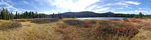 Panoramic View of Santiam Lake in early Autumn.

References[]
- ^ "Mount Jefferson Wilderness". U.S. Forest Service. Retrieved December 10, 2013.
This Linn County, Oregon state location article is a stub. You can help Wikipedia by . |
Categories:
- Lakes of Oregon
- Lakes of Linn County, Oregon
- Willamette National Forest
- Protected areas of Linn County, Oregon
- Oregon geography stubs