Sarisbury
| Sarisbury Sarisbury Green | |
|---|---|
| Area | 2.98 sq mi (7.7 km2) |
| Population | 7,385 |
| • Density | 2,478/sq mi (957/km2) |
| Country | England |
| Sovereign state | United Kingdom |
Sarisbury is a village to the west of Park Gate within the borough of Fareham, Hampshire, in the south of England.[1] Its focal point is Sarisbury Green (the two names are interchangeable) and the parish church of St Paul, formerly part of Titchfield parish. In previous times it was a rural locality dependent on fruit growing. At the 2011 Census the population of the ward was 7,385.[2] Nearby villages include Bursledon, Hamble-le-Rice and Swanwick.
History[]
In 1837, Sarisbury, formerly in Titchfield ecclesiastical parish, became a parish in its own right. In 1894, Sarisbury with Swanwick was made a civil parish.[3] However, in 1868, Sarisbury was still being described as a chapelry in the parish of Titchfield, so the establishment date of the parish is unclear.[4]
Sarisbury Green originated as a tongue of land at the extremity of Titchfield Common which was left when the rest was enclosed.[5]
The surrounding area used to be the main provider of strawberries to the whole of the UK. Additionally there used to be apple orchards along the side of the main road through the village, Bridge Road.
Sport[]
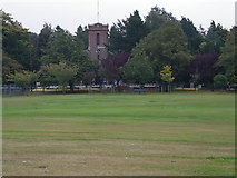
A village with two traditional cricket greens, Sarisbury Green is also the home of Holly Hill Country Park.[6] The cricket greens are used by Sarisbury Athletic Cricket Club. One pitch is opposite the One Stop convenience store on Bridge Road and the other is next to the junior school on Allotment Road. The one on Bridge Road, "The Green" is used by a variety of teams on Sundays and on Saturdays by Locks Heath 3rd XI and Sarisbury Athletic 3rd XI. Sarisbury U-15s also play there. Allotment Road pitch, "The Hollow" is Sarisbury Athletic's main ground where they have their own club house. Adjacent to "The Green" is a set of two tennis courts, the Sarisbury Parish Rooms and the village Community Centre.
Education[]
The village is home to an infant and corresponding junior school, namely Sarisbury Infant School (for 4-7 year olds) and Sarisbury Church of England Controlled Junior School (for 7-11 year olds) as well as a secondary school, Brookfield Community School. Many pupils start at the infant school at the age of 4, move to the junior school at the age of 7, and continue all the way to GCSE level at the age of 16 at Brookfield School.
Worship[]
The village has two Christian churches: St Paul's Church of England Church, originally a district church of Titchfield Parish,[7][8] built in 1836 to a design by Jacob Owen, and a United Reformed Church.[9][10] Holly Hill Cemetery is nearby.[11]
Events[]
Every June the village holds a Fayre on the Green, home to the "Swanwick Rollercoaster" and many other attractions, occasionally including a pair of llamas.[citation needed]
Transport[]
A bus route from Southampton to Gosport serves the village, stopping at the three bus stops. Trains on the West Coastway Line serve the two nearby railway stations of Swanwick and Bursledon.
See also[]
References[]
- ^ "Fareham Borough Council: Sarisbury". 21 January 2013. Retrieved 13 October 2017.
- ^ (2011 Census. Ward)"Fareham Ward population 2011". Neighbourhood Statistics. Office for National Statistics. Retrieved 9 January 2016.
- ^ "British History Online: Titchfield". Retrieved 21 February 2019.
- ^ "National Gazeteer of Britain and Ireland". Retrieved 22 February 2019.
- ^ "The Buildings of Hampshire and the Isle of Wight" Pevsner,N: Harmondsworth, Penguin, 1967 ISBN 0-14-071032-9
- ^ "Fareham Borough Council: Holly Hill Woodland Park". Retrieved 21 August 2021.
- ^ Church Web Site
- ^ "GENUKI: St Paul, Sarisbury Green". Retrieved 21 February 2019.
- ^ "GENUKI: Sarisbury Green URC, Sarisbury Green". Retrieved 21 February 2019.
- ^ "GENUKI: Titchfield". Retrieved 21 February 2019.
- ^ "GENUKI: Holly Hill Cemetery, Sarisbury". Retrieved 21 February 2019.
External links[]
| Wikimedia Commons has media related to Sarisbury Green. |
| Wikimedia Commons has media related to Sarisbury. |

- Villages in Hampshire
- Borough of Fareham