Sas dla Crusc
| Sas dla Crusc | |
|---|---|
 | |
| Highest point | |
| Elevation | 2,907 m (9,537 ft) |
| Prominence | 70 m (230 ft) |
| Coordinates | 46°36′51.6″N 11°57′4.5″E / 46.614333°N 11.951250°ECoordinates: 46°36′51.6″N 11°57′4.5″E / 46.614333°N 11.951250°E |
| Geography | |
| Location | South Tyrol, Italy |
| Parent range | Fanes group |

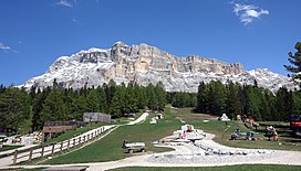
The Sas dla Crusc (German: Heiligkreuzkofel, Italian: Sasso di Santa Croce [ˈsasso di ˈsanta ˈkroːtʃe]) is a mountain of the Fanes group in South Tyrol, Italy.
References[]
- Alpenverein South Tyrol (in German)
External links[]
![]() Media related to Heiligkreuzkofel at Wikimedia Commons
Media related to Heiligkreuzkofel at Wikimedia Commons
Categories:
- Mountains of the Alps
- Mountains of South Tyrol