Satara district
Satara district | |
|---|---|
District of Maharashtra | |
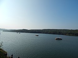 Venna Lake | |
 | |
| Country | |
| State | Maharashtra |
| Division | Pune |
| Headquarters | Satara (city) |
| Area | |
| • Total | 10,480 km2 (4,050 sq mi) |
| Population (2011) | |
| • Total | 3,003,741 |
| • Density | 209/km2 (540/sq mi) |
| Languages | |
| • Official | Marathi |
| Time zone | UTC+5:30 (IST) |
| Tehsils | 1. Satara, 2. Karad, 3. Wai, 4. Mahabaleshwar, 5. Phaltan, 6. Maan, 7. Khatav, 8. Koregaon, 9. Patan, 10. Jaoli, 11. Khandala |
| LokSabha | 1. Satara, 2. Madha (shared with Solapur district) |
| Major Highways | NH-4 |
| Website | www |

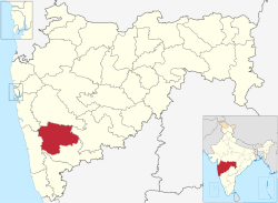
Satara district (Marathi pronunciation: [saːt̪aɾaː]) is a district of Maharashtra state in western India with an area of 10,480 km2 (4,050 sq mi) and a population of 3,003,741 of which 14.17% were urban (as of 2011).[1][2] Satara is the capital of the district and other major towns include Medha, Wai, Karad, Koregaon, , Koynanagar, Rahimatpur, Phaltan, Mahabaleshwar, Vaduj and Panchgani. This district comes under Pune Administrative Division along with Pune, Sangli, Solapur and Kolhapur. The district of Pune bounds it to the north, Raigad bounds it to the north-west, Solapur the east, Sangli to the south, and Ratnagiri to the west.[3]
The Sahyadri range, or main range of the Western Ghats, runs north and south along the western edge of the district, separating it from Ratnagiri District. The Mahadeo range starts about 10 m. north of Mahabaleshwar and stretches east and south-east across the whole of the district. The Mahadeo hills are bold, presenting bare scarps of black rock like fortresses. The Satara district is part of two main watersheds. The Bhima River watershed, which is a tributary of the Krishna, includes the north and northeast of the district, north of the Mahadeo hills. The rest of the district is drained by the upper Krishna and its tributaries. The hill forests have a large store of timber and firewood. The whole of Satara district falls within the Deccan Traps area; the hills consist of trap intersected by strata of basalt and topped with laterite, while, of the different soils on the plains, the commonest is the black loamy clay containing carbonate of lime. This soil, when well watered, is capable of yielding heavy crops. Satara contains some important irrigation works, including the Krishna canal. In some of the western parts of the district the average annual rainfall exceeds 5 m.; but on the eastern side water is scanty, the rainfall varying from 1 m in Satara town to less than 30 cm (12 in) in some places farther east. The district is traversed from north to south by a railway line, which passes 15 km (9.3 mi) east of Satara town.[4]
The Mandher Devi temple in Mandhradevi, near Wai, is the Kalubai temple. Located on a hill 1,417 m (4,649 ft) above sea level, the temple, some 20 km (12 mi) from Wai, overlooks the picturesque Purandhar fort. Devotees attribute miraculous properties to a grove around the shrine. Lore has it that the temple is more than 400 years old and was built during Shivaji's Maratha rule. However, no definite date on the temple's construction is available. It was the scene of a tragic stampede on 25 January 2005.
History[]
Historical inscriptions as old as 200 BCE indicate the oldest known place in Satara district in Maharashtra is Karad (mentioned as Karhakada). It is also believed that the Pandavas stayed in Wai, then known as 'Viratnagari', in the 13th year of exile.
Satara District can be proud of the oldest Rashtrakuta history. The oldest Rashtrakutas are believed to be from ancient Kuntala in the valley of river Krishna. Manank ruled from 350–375 C.E. and had built his capital in "Manpur" (now Maan in Satara district). The Vakatakas of Vidarbha, another Rashtrakuta rulers[clarification needed] were in conflict with Manank. Subsequently, the Rashtrakutas became feudatories to the Chalukyas and came into prominence under Dantidurga around 753 CE.
The empire of Chandragupta II, known as Mahendraditya Kumargupta I, extended as far as Satara district in Deccan when he ruled between 451 AD to 455 AD. The Mauryan empire in the Deccan was followed by the rule of the "Satvahanas" for about two centuries between 550 A.D. to 750 AD.
The first Muslim invasion of the Deccan took place in 1296. In 1636, the Nizam Shahi dynasty came to an end. In 1663 Maratha Chatrapati Shivaji Maharaj conquered Parali and won Satara fort. After the death of Shivaji, Aurangzeb conquered Satara fort, later won by Parshuram Pratinidhi in 1706. In 1708, Chattrapati Shahu was crowned within the Satara fort. The direct descendants of Chatrapati Shivaji Maharaj, continue to live in Satara.
After their victory in the Third Anglo-Maratha War in 1818, the British Empire annexed most of the Maratha territory to Bombay Presidency, but restored the titular Raja Pratap Singh, and assigned to him the principality of Satara, an area much larger than the present district. As a result of political intrigues, Pratap Singh was deposed in 1839, and his brother Raja Shahaji was placed on the throne. When this prince died without a male heir in 1848, Satara was annexed by the British government and added to Bombay Presidency.
Divisions[]
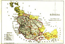
Satara district consists of four subdivisions namely Satara, Wai, Karad and Phaltan, divided into eleven talukas (tahsils).[5] These are Satara, Karad, Wai, Mahabaleshwar, Phaltan, Man, Khatav, Koregaon, Patan, Jaoli and Khandala. There are eight Vidhan Sabha constituencies in this district. Karad North, Karad South, Patan, Koregaon, Wai and Satara are part of Satara (Lok Sabha constituency) and Phaltan, Man are part of Madha (Lok Sabha constituency).
| Taluka | Capital |
|---|---|
| Satara | Satara |
| Karad | Karad |
| Wai | Wai |
| Koregaon | Koregaon |
| Jaoli | |
| Mahabaleshwar | Mahabaleshwar |
| Khandala | Khandala |
| Patan | Patan |
| Phaltan | Phaltan |
| Khatav | Vaduj |
| Maan |
Later, in the year 2009, the Karad (Lok Sabha constituency) was cancelled and it fused in the Satara (Lok Sabha constituency) . A new Madha (Lok Sabha constituency) was formed in the same year. Jaoli and Khatav Vidhan Sabha constituencies were cancelled, and Man, Phaltan were added to Madha (Lok Sabha constituency).
Demographics[]
According to the 2011 census Satara district has a population of 3,003,741,[6] roughly equal to the nation of Albania[7] or the US state of Mississippi.[8] This gives it a ranking of 122nd in India (out of a total of 640).[6] The district has a population density of 287 inhabitants per square kilometre (740/sq mi) .[6] Its population growth rate over the decade 2001–2011 was 6.93%.[6] Satara has a sex ratio of 988 females for every 1000 males,[6] and a literacy rate of 82.87%. Scheduled Castes and Scheduled Tribes made up 10.76% and 0.99% of the population respectively.[6]
According to the 2011 census Hinduism is the principal religion followed by 89.63% of district population, while Muslims constituted 4.89% of district population. Buddhism followed by 4.70% of district population.
At the time of the 2011 Census of India, 95.05% of the population in the district spoke Marathi and 3.60% Hindi as their first language.[10]
| Year | Pop. | ±% p.a. |
|---|---|---|
| 1901 | 849,672 | — |
| 1911 | 835,337 | −0.17% |
| 1921 | 786,436 | −0.60% |
| 1931 | 895,014 | +1.30% |
| 1941 | 1,013,212 | +1.25% |
| 1951 | 1,177,016 | +1.51% |
| 1961 | 1,430,105 | +1.97% |
| 1971 | 1,727,376 | +1.91% |
| 1981 | 2,038,677 | +1.67% |
| 1991 | 2,451,372 | +1.86% |
| 2001 | 2,808,994 | +1.37% |
| 2011 | 3,003,741 | +0.67% |
| source:[11] | ||
Education[]
The Sainik School in Satara is one of the oldest residential school preparing boys for military career. The boys are prepared for NDA (National Defence Academy) UPSC examination, and also for technical entries of Army Navy And The Airforce. Ex Chief of the Air Staff, Air Chief Marshal Pradeep Vasant Naik is an alumnus of this institution, amongst many officers serving or served in Indian Armed Forces. This is the First Sainik School established in India and comes under Ministry of Defence.
Krantisinh Nana Patil College of Veterinary Science, Shirwal is affiliated with Maharashtra Animal and Fishery Sciences University.
There are also institutes run by the Rayat Shikshan Sanstha. Karmaveer Bhaurao Patil College Of Engineering and Polytechnic is run by Rayat Shikshan Sanstha and is one of the oldest and reputed engineering colleges in Satara.
In primary education SEMS, Mona School Satara, Nirmala Convent, KSD Shanbhag Vidyalaya, Chhatrapati Shahu Academy, Narmada are some of the best and oldest English Medium schools which are affiliated to Maharashtra state board while the Podar International School is the most excellent school which is affiliated to Central Board Of Secondary Education.[12] Amongst Marathi medium schools, Rayat Shikshan sansthas Anna Saheb Kalyani Vidyalaya, Maharaja Sayajirao Vidyalaya along with Anant English School, and New English School are the best educational institutes in the city.[13]
Further reading[]
- Malik, S.C. Stone Age Industries of the Bombay & Satara Districts, M. Sayajirao University Baroda 1959.
- Selections from the Historical Records of the Hereditary Minister of Baroda. Consisting of letters from Bombay, Baroda, Poona and Satara Governments. Collected by B.A. Gupte. Calcutta 1922.
References[]
- ^ "Indian Districts by Population, Sex Ratio, Literacy 2011 Census". Census2011.co.in. 2010-04-01. Retrieved 2015-08-07.
- ^ [1] Archived July 12, 2006, at the Wayback Machine
- ^ Map of districts in Maharashtra
- ^ One or more of the preceding sentences incorporates text from a publication now in the public domain: Chisholm, Hugh, ed. (1911). "Satara". Encyclopædia Britannica. 24 (11th ed.). Cambridge University Press. p. 227.
- ^ "Satara: Province to District". Satara District. Archived from the original on September 29, 2013.
- ^ Jump up to: a b c d e f "District Census 2011". Census2011.co.in. 2011. Retrieved 2011-09-30.
- ^ US Directorate of Intelligence. "Country Comparison:Population". Retrieved 2011-10-01.
Albania 2,994,667 July 2011 est.
- ^ "2010 Resident Population Data". U. S. Census Bureau. Retrieved 2011-09-30.
Mississippi 2,967,297
- ^ "C-16 Population By Religion - Maharashtra". census.gov.in.
- ^ 2011 Census of India, Population By Mother Tongue
- ^ Decadal Variation In Population Since 1901
- ^ "Podar Education Network". Podareducation.org. Retrieved 2015-08-07.
- ^ "Rayat Shikshan Sanstha Founder Dr. Karmaveer Bhaurao Patil, Established-1919". Rayatshikshan.edu. Retrieved 2015-08-07.
External links[]
| Wikimedia Commons has media related to Satara district. |
| show Places adjacent to Satara district |
|---|
| show Satara district topics |
|---|

| show |
|---|
| show Authority control |
|---|

- Satara district
- Districts of Maharashtra
- Pune division