Savitri River
| Savitri | |
|---|---|
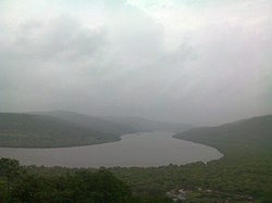 Savitri River in Konkan | |
| Location | |
| Country | India |
| State | Maharashtra |
| Physical characteristics | |
| Source | Savitri Point, Mahabaleshwar |
| Mouth | |
• location | Bankot creek, Near Harihareshwar, Konkan, Arabian Sea |
| Length | Around 110 km (68 mi) |


Savitri River is one of the 5 rivers which originate from Mahabaleshwar in Maharashtra state in India.It originates at Savitri point near Mahabaleshwar and flows through the bankot village and directly goes to Arabian sea Raigad district[1] and eventually meets Arabian Sea at Harehareshwar. It passes through rocky and hilly terrain of western ghats till Poladpur and further through the towns of Mahad, Mangaon and Shrivardhan Tehsil (taluka). There are a number of Shiva temples along the banks of river Savitri. Many other small rivers get merged into it at Kapade, Poladpur and Birwadi. Its major tributary is the which enters from the right (north) near Dasgaon.[2]
More than 24 people were reported missing, on August 3, 2016, when a British era bridge collapsed due to heavy rains near Raigad district.[3] Two state transport buses and several vehicles reportedly plunged into the river.[4]
The other four rivers originating from Mahabaleshwar (Panchganga) are: Gayatri River, Koyna River, Krishna River, and Venna River.
References[]
- ^ Deshpande, Swati (18 November 2011). "No sand mining till green nod, HC tells Maharashtra govt". Times of India. Mumbai. Retrieved Mar 3, 2015.
- ^ Savitri river basin
- ^ "Mumbai-Goa highway bridge collapses, 2 buses carrying 18 people missing". 2016-08-03. Retrieved 2016-08-03.
- ^ "Over 20 Missing After British-Era Bridge On Mumbai-Goa Highway Collapses: 10 Updates". Retrieved 2016-08-03.
| Wikimedia Commons has media related to Savitri River. |
| show Satara district topics |
|---|

| show Raigad district |
|---|

| show Authority control |
|---|
Coordinates: 17°58′N 73°02′E / 17.967°N 73.033°E

- Rivers of Maharashtra
- Rivers of India