Saw Mill Run
| Saw Mill Run Tributary to Ohio River | |
|---|---|
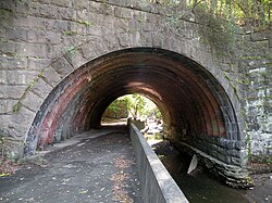 The , built in 1903, over Saw Mill Run along Saw Mill Run Boulevard not far from Woodruff Street in the Beechview neighborhood of Pittsburgh, Pennsylvania | |
 Location of Saw Mill Run mouth | |
| Location | |
| Country | United States |
| State | Pennsylvania |
| County | Allegheny County |
| City | Pittsburgh |
| Borough/Township | Castle Shannon Mt. Lebanon |
| Physical characteristics | |
| Source | McLaughlin Run divide |
| • location | Mt. Lebanon, Pennsylvania |
| • coordinates | 41°41′06″N 080°02′10″W / 41.68500°N 80.03611°W[1] |
| • elevation | 1,180 ft (360 m)[2] |
| Mouth | Ohio River |
• location | Mount Washington Overlook, Pennsylvania |
• coordinates | 41°26′40″N 080°01′38″W / 41.44444°N 80.02722°WCoordinates: 41°26′40″N 080°01′38″W / 41.44444°N 80.02722°W[1] |
• elevation | 710 ft (220 m)[3] |
| Length | 9.12 mi (14.68 km)[4] |
| Basin size | 19.42 square miles (50.3 km2)[5] |
| Discharge | |
| • location | Ohio River |
| • average | 19.57 cu ft/s (0.554 m3/s) at mouth with Ohio River[5] |
| Basin features | |
| Progression | northeast then northwest[4] |
| River system | Ohio River |
| Tributaries | |
| • left | unnamed tributaries |
| • right | unnamed tributaries |
| Bridges | Santa Fe Drive, Caswell Drive, Milford Drive (x2), Connor Road, Willow Avenue, Canal Street, Castle Shannon Boulevard, Killarney Drive, PA 88, Kingwood Street, PA 51 (x2), Whited Street, PA 51, Fawn Street, Fine Way. PA 51, Edgebrook Avenue, PA 51 (x2), Crane Avenue, I-376, Miniotte Square, Neptune Street, S Main Street, PA 51 |


Saw Mill Run is a tributary of the Ohio River in Pennsylvania. It is an urban stream, and lies entirely within Allegheny County, Pennsylvania. The stream enters the Ohio just downstream from the Forks of the Ohio in Pittsburgh, at a place that was founded as the town of Temperanceville in the 1830s. It provides an entry through the elevated plateau south of Pittsburgh known as the South Hills, and land transportation has paralleled the stream since the nineteenth century.
The stream is named for an actual saw mill that operated near the mouth of the stream where it empties into the Ohio River. The first reference to the mill is in relation to the construction of Fort Pitt (1759–1761). The mill provided much of the lumber used in the construction of the new Fort, after the British claimed the area from the French and destroyed Fort Duquesne.[6]
Railroads[]
The Coal Hill Coal Railroad crossed the stream on a trestle, and extended upstream in 1861. This railroad was purchased by the Pittsburgh and Castle Shannon Railroad, who extended the line to follow the main stream of Saw Mill Run from the Pittsburgh and Castle Shannon Tunnel to Castle Shannon, Pennsylvania. The Little Saw Mill Run Railroad followed the west branch of the stream towards Mt. Lebanon, Pennsylvania.[7]
The Wheeling and Lake Erie Railway (W&LE) operated a short rail line on the western end of the stream, known as the West End Branch. It had been used by the Pittsburgh and West Virginia Railway as a connection with the Pittsburgh and Lake Erie Railroad near West Carson Street. The W&LE operated it until late 2008,[8][9] and most of the line has been torn up, with the crossing signal cantilevers on Steuben Street being removed in 2012.[citation needed]
Trolley and light rail[]
The right of way of the Pittsburgh and Castle Shannon, excluding the Pittsburgh and Castle Shannon Tunnel through a coal mine, was leased by Pittsburgh Railways in 1905, and later purchased in 1950. The railroad ran with a dual gauge system, with coal trains continuing to run on the narrow gauge, and at night, and trolleys on a wider gauge. The right of way is part of the Pittsburgh Light Rail transportation system today, which follows the stream from near the South Hills Junction (PAT station) to Castle Shannon, Pennsylvania.
Highways[]
Part of Pennsylvania Route 51 runs parallel to the stream, and this section is known as Saw Mill Run Boulevard.
Watershed[]
The watershed of Saw Mill Run covers 12,432 acres (50.31 km2), or about 19 square miles (49 km2). The main stream is 9.3 miles (15.0 km) long, and drains parts of Bethel Park, Castle Shannon, Mount Oliver, and the city of Pittsburgh.[10]
See also[]
References[]
| Wikimedia Commons has media related to Saw Mill Run. |
- ^ Jump up to: a b "GNIS Detail - Sawmill Run". geonames.usgs.gov. US Geological Survey. Retrieved 12 May 2021.
- ^ "Get Maps". USGS Topoview. US Geological Survey. Retrieved 12 May 2021.
- ^ "Get Maps". USGS Topoview. US Geological Survey. Retrieved 12 May 2021.
- ^ Jump up to: a b "ArcGIS Web Application". epa.maps.arcgis.com. US EPA. Retrieved 12 May 2021.
- ^ Jump up to: a b "Sawmill Run Watershed Report". US EPA Geoviewer. US EPA. Retrieved 12 May 2021.
- ^ Lorant, Stefan (1999). Pittsburgh: The story of an American city (5th ed.). Esselmont Books. ISBN 0967410304. OCLC 42704989.
- ^ Pennsylvania, Geological Survey of (1887). Annual Report of the Geologic Survey of Pennsylvania for 1885-1887. p. 161.
- ^ http://www.post-gazette.com/stories/local/neighborhoods-city/west-end-circle-traffic-still-dealing-with-a-snag-301791
- ^ http://www.post-gazette.com/breaking/2012/01/11/West-End-railroad-underpass-that-snarled-traffic-to-come-down/stories/201201110176
- ^ "AMD and Sediment MDLs for Sawmill Run" (PDF). Retrieved 2009-05-24.[dead link]
| hide Authority control | |
|---|---|
| General |
|
| National libraries | |
- Pittsburgh metropolitan area
- Rivers of Pennsylvania
- Tributaries of the Ohio River
- Rivers of Allegheny County, Pennsylvania