Scharnstein
Scharnstein | |
|---|---|
 | |
 Coat of arms | |
 Scharnstein Location within Austria | |
| Coordinates: 47°54′01″N 13°57′39″E / 47.90028°N 13.96083°ECoordinates: 47°54′01″N 13°57′39″E / 47.90028°N 13.96083°E | |
| Country | Austria |
| State | Upper Austria |
| District | Gmunden |
| Government | |
| • Mayor | Rudolf Raffelsberger (ÖVP) |
| Area | |
| • Total | 47.79 km2 (18.45 sq mi) |
| Elevation | 488 m (1,601 ft) |
| Population (2018-01-01)[2] | |
| • Total | 4,819 |
| • Density | 100/km2 (260/sq mi) |
| Time zone | UTC+1 (CET) |
| • Summer (DST) | UTC+2 (CEST) |
| Postal code | 4644 |
| Area code | 07615 |
| Vehicle registration | GM |
| Website | www.scharnstein. ooe.gv.at |

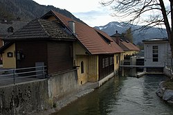
Scharnstein is a municipality in the district of Gmunden in the Austrian state of Upper Austria.
Geography[]
Scharnstein lies in the heart of the Alm valley. About 55 percent of the municipality is forest, and 36 percent is farmland.
References[]
- ^ "Dauersiedlungsraum der Gemeinden Politischen Bezirke und Bundesländer - Gebietsstand 1.1.2018". Statistics Austria. Retrieved 10 March 2019.
- ^ "Einwohnerzahl 1.1.2018 nach Gemeinden mit Status, Gebietsstand 1.1.2018". Statistics Austria. Retrieved 9 March 2019.
| Wikimedia Commons has media related to Scharnstein. |
| show Authority control |
|---|
This Upper Austria location article is a stub. You can help Wikipedia by . |
Categories:
- Cities and towns in Gmunden District
- Upper Austria geography stubs