Schlatt (Bad Krozingen)
Schlatt | |
|---|---|
Ortsteil of Bad Krozingen | |
 Coat of arms | |
show Location of Schlatt | |
 Schlatt | |
| Coordinates: 47°55′33″N 7°40′25″E / 47.92583°N 7.67361°ECoordinates: 47°55′33″N 7°40′25″E / 47.92583°N 7.67361°E | |
| Country | Germany |
| State | Baden-Württemberg |
| Admin. region | Freiburg |
| District | Breisgau-Hochschwarzwald |
| Town | Bad Krozingen |
| Government | |
| • Local representative | Ottmar Seywald (CDU) |
| Area | |
| • Total | 5.74 km2 (2.22 sq mi) |
| Population (2018-02-01[1]) | |
| • Total | 1,292 |
| • Density | 230/km2 (580/sq mi) |
| Time zone | UTC+01:00 (CET) |
| • Summer (DST) | UTC+02:00 (CEST) |
| Postal codes | 79189 |
| Dialling codes | 07633 |
| Vehicle registration | FR |


Schlatt is a village in the district of Breisgau-Hochschwarzwald in Baden-Württemberg. Since January 1973, it is an Ortsteil of Bad Krozingen.[2]
Gallery[]

St. Sebastian Church

St. Sebastian, church entrance
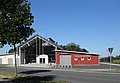
"Quellenhalle" (community centre) and fire station, opened in 2011


References[]
- ^ Stadt Bad Krozingen. "Zahlen und Fakten" (in German). Archived from the original on 2018-03-17. Retrieved 2018-03-17.
- ^ Stadt Bad Krozingen. "Ortsteil Schlatt" (in German). Archived from the original on 2018-03-17. Retrieved 2018-03-17.
| Authority control |
|---|
This Breisgau-Hochschwarzwald location article is a stub. You can help Wikipedia by . |
Categories:
- Breisgau-Hochschwarzwald
- Baden
- Freiburg region geography stubs