Schleiz
Schleiz | |
|---|---|
 Church in Schleiz | |
 Coat of arms | |
show Location of Schleiz within Saale-Orla-Kreis district | |
 Schleiz | |
| Coordinates: 50°35′0″N 11°49′0″E / 50.58333°N 11.81667°ECoordinates: 50°35′0″N 11°49′0″E / 50.58333°N 11.81667°E | |
| Country | Germany |
| State | Thuringia |
| District | Saale-Orla-Kreis |
| Subdivisions | 15 |
| Government | |
| • Mayor (2018–24) | Marko Bias[1] (CDU) |
| Area | |
| • Total | 108.22 km2 (41.78 sq mi) |
| Elevation | 432 m (1,417 ft) |
| Population (2020-12-31)[2] | |
| • Total | 8,832 |
| • Density | 82/km2 (210/sq mi) |
| Time zone | UTC+01:00 (CET) |
| • Summer (DST) | UTC+02:00 (CEST) |
| Postal codes | 07901–07907 |
| Dialling codes | 03663 |
| Vehicle registration | SOK |
| Website | www.schleiz.de |


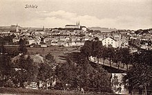

Schleiz is a town in the district of Saale-Orla-Kreis in Thuringia, Germany. The former municipality Crispendorf was merged into Schleiz in January 2019, and Burgk in December 2019.
Location[]
Schleiz is in the Thuringian Vogtland area, an area of wooded hills on the borders of Thuringia, Saxony, Bavaria and the Czech Republic. The city is located in a valley with the river Wisenta near the motorway A 9 (Berlin – München).
Neighboring parishes[]
| Crispendorf (6 km) | Görkwitz (2 km) | Oettersdorf (3 km) | Löhma (5 km) | Kirschkau (6 km) | Zeulenroda-Triebes (14 km) |
| Remptendorf (12 km) | 
|
Pausa (13 km) | |||
| Saalburg-Ebersdorf (12 km) | Tanna (10 km) | Mühltroff (9 km) |
Distances calculated as between town centers.
Subdivisions[]
Schleiz includes the following subdivisions:
- Möschlitz
- Grochwitz
- Oberböhmsdorf
- Lössau
- Langenbuch
- Wüstendittersdorf
- Dröswein
- Gräfenwarth
- Oschitz
- Heinrichsruh
- Crispendorf
- Burgk
History[]
Schleiz can be traced back to a settlement established about 1200 ("Altstadt") and a separate "Neustadt" that was established next to it. The "Neustadt" had a castle and a city wall. Until 2 December 1482 they were totally separate communities after which they combined to one city.[citation needed] There was a settlement of the Teutonic Order here, and for some years previous to 1848 the town was the capital of the small principality of Reuss-Schleiz. In the vicinity a battle was fought, between the French and the Prussians on 9 October 1806.[3]
Within the German Empire (1871-1918), Schleiz was part of the Principality of Reuss-Gera.
20th Century[]
During World War II hundreds of women and men from several nations, including the Soviet Union were transported to Schleiz as forced laborers. At least 60 of them died there.
The palace was destroyed April 1945.[4]
Population[]
Trend of population figures:
|
1834 — 1995 |
1996 — 2002
|
2003 — 2009
|
Recreation[]
Schleiz is also the site of the Schleizer Triangle motor racing track.

Notable people[]
- Johann Friedrich Böttger (1682–1719), alchemist and co-inventor of European porcelain
- Heinrich Gottfried Piegler (1797–1849), probably the largest manufacturer of Döbereiner's lamps
- Richard Barthold (1855-1932), US-american politician
- Theodor Piegler (1904-1991), great-grandson of H.G. Piegler, co-owner of the internationally active metal goods factory for hairdressing articles "Gebr. Piegler" in Nuremberg
- Joachim Blechschmidt (1912-1943), German pilot and fighter ace in World War II
- Bernhard Klee (born 1936), conductor
References[]
- ^ Gewählte Bürgermeister - aktuelle Landesübersicht, Freistaat Thüringen, accessed 14 July 2021.
- ^ "Bevölkerung der Gemeinden, erfüllenden Gemeinden und Verwaltungsgemeinschaften in Thüringen Gebietsstand: 31.12.2020". Thüringer Landesamt für Statistik (in German). June 2021.
- ^ Chisholm 1911, p. 334.
- ^ Klimpke, Juergen (2005). Als der Tod vom Himmel fiel. Der 8. April 1945. Schleizer Heimathefte. 38. Schleiz: Klimpke. p. 26.
- ^ from 1960 on always as of 31 December
- ^ Source from 1994 onwards: Thüringer Landesamt für Statistik
- Attribution
- This article incorporates text from a publication now in the public domain: Chisholm, Hugh, ed. (1911). "Schleiz". Encyclopædia Britannica. 24 (11th ed.). Cambridge University Press. p. 334.
External links[]
- http://www.schleiz.de Official web site for Stadt Schleiz. (in German)
| show Towns and municipalities in Saale-Orla-Kreis |
|---|
| show Authority control |
|---|
- Towns in Thuringia
- Saale-Orla-Kreis
- Principality of Reuss-Gera
- Bezirk Gera