Schleptruper Egge
This article does not cite any sources. (June 2019) |
| Schleptruper Egge | |
|---|---|
 Schleptruper Egge | |
| Highest point | |
| Elevation | 148 m above sea level (NHN) (486 ft) |
| Listing | |
| Coordinates | 52°22′27″N 8°01′52″E / 52.374297°N 8.03117°ECoordinates: 52°22′27″N 8°01′52″E / 52.374297°N 8.03117°E |
| Geography | |
| Location | Bramsche |
| Parent range | Wiehen Hills |

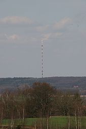
The landmark on the Schleptruper Egge is the over-230-metre-high mast of the NDR
The Schleptruper Egge is a hill, 148 m high, in the Bramsche parish of Schleptrup and is part of the Wiehen Hills. To the north is the bog of Großes Moor at a height of about 47 m above sea level (NHN), the Mittelland Canal built in the 20th century and the Bramsche parish of Kalkriese. Immediately east of the Schleptruper Egge runs the A 1 motorway, the so-calle Hanseatic Line (Hansalinie).
On the top of the Schleptruper Egge is the mast of the NDR . The long distance path of , managed by the Weser-Ems Wiehen Hills Society (Wiehengebirgsverband Weser-Ems), which runs from Osnabrück to Papenburg, also leads over the Schleptruper Egge.
Categories:
- Hills of Lower Saxony
- Wiehen Hills
- Osnabrück (district)