Schwägalp Pass
| Schwägalp Pass | |
|---|---|
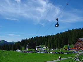 Aerial tramway up Säntis from Schwägalp | |
| Elevation | 1,278 m (4,193 ft) |
| Traversed by | Road |
| Location | Switzerland |
| Range | Alps |
| Coordinates | 47°15′42″N 09°19′50″E / 47.26167°N 9.33056°ECoordinates: 47°15′42″N 09°19′50″E / 47.26167°N 9.33056°E |
 Schwägalp Pass Location of Schwägalp Pass | |


Schwägalp Pass (el. 1,278 m or 4,193 ft) is a high mountain pass in the Alps between the cantons of St. Gallen and Appenzell Ausserrhoden in Switzerland.
It connects in Toggenburg in St. Gallen and Urnäsch in Appenzell Ausserrhoden. It is named after the Schwägalp peak (el. 1,360 m or 4,462 ft) on the north face of Säntis (el. 2,502 m or 8,209 ft), which is the starting point of the aerial tramway to the top of Säntis. It was built in 1935.
The pass road has a maximum grade of 12 percent (12%).
See also[]
| Wikimedia Commons has media related to Schwägalp. |
- List of highest paved roads in Europe
- List of mountain passes
- List of the highest Swiss passes
| hide Authority control | |
|---|---|
| General |
|
| Other | |
This Canton of St. Gallen location article is a stub. You can help Wikipedia by . |
This Appenzell Ausserrhoden location article is a stub. You can help Wikipedia by . |
Categories:
- Mountain passes of Appenzell Ausserrhoden
- Mountain passes of Switzerland
- Mountain passes of the Alps
- Mountain passes of the canton of St. Gallen
- Canton of St. Gallen geography stubs
- Switzerland geography stubs