Scorff
| Scorff | |
|---|---|
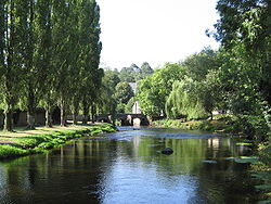 The Scorff in Pont-Scorff | |
| Location | |
| Country | France |
| Physical characteristics | |
| Source | |
| • location | Brittany |
| Mouth | |
• location | Blavet |
• coordinates | 47°44′30″N 3°20′54″W / 47.74167°N 3.34833°WCoordinates: 47°44′30″N 3°20′54″W / 47.74167°N 3.34833°W |
| Length | 78.6 km (48.8 mi) |
| Discharge | |
| • average | 15 m3/s (530 cu ft/s) |

The Scorff (French pronunciation: [skɔʁf]; Breton: Skorf) River flows from central Brittany and enters the Atlantic Ocean on the south coast in Lorient.
The Scorff rises north of Langoëlan, in the Morbihan department, and flows through the towns of Guémené-sur-Scorff and Pont-Scorff. From there its bed enlarges to form a ria, submitted to the tides. It joins the Blavet in Lorient, where it enters the Ocean in the .
It is 78.6 km (48.8 mi) long and its basin area is 483 km2 (186 sq mi).[1]
Fauna[]
The river is classified for fishing as "first category" (French: Cours d'eau de première catégorie);[2] it is home to Brown trout and Atlantic salmon.
References[]
- ^ Sandre. "Fiche cours d'eau - Scorff (J5--0220)".
- ^ Morbihan angling association: Fédération départementale de pêche du Morbihan
| hide Authority control | |
|---|---|
| General |
|
| National libraries | |
| Other |
|
This Brittany geographical article is a stub. You can help Wikipedia by . |
Categories:
- Coastal basins of the Bay of Biscay
- Rivers of France
- Rivers of Brittany
- Rivers of Côtes-d'Armor
- Rivers of Morbihan
- Brittany geography stubs
- France river stubs